STS049-79-24
| NASA Photo ID | STS049-79-24 |
| Focal Length | 250mm |
| Date taken | 1992.05.10 |
| Time taken | 21:22:38 GMT |

Cloud masks available for this image:
Spacecraft nadir point: 27.9° N, 77.7° W
Photo center point: 28.0° N, 80.0° W
Photo center point by machine learning:
Photo center point: 28.0° N, 80.0° W
Photo center point by machine learning:
Nadir to Photo Center: West
Spacecraft Altitude: 198 nautical miles (367km)
Country or Geographic Name: | USA-FLORIDA |
Features: | C. CANAVERAL, SATELLITE |
| Features Found Using Machine Learning: | |
Cloud Cover Percentage: | 0 (no clouds present) |
Sun Elevation Angle: | 28° |
Sun Azimuth: | 276° |
Camera: | Hasselblad |
Focal Length: | 250mm |
Camera Tilt: | 35 degrees |
Format: | 5017: Kodak, natural color positive, Ektachrome, X Professional, ASA 64, standard base |
Film Exposure: | Normal |
| Additional Information | |
| Width | Height | Annotated | Cropped | Purpose | Links |
|---|---|---|---|---|---|
| 5700 pixels | 6000 pixels | No | No | Download Image | |
| 500 pixels | 526 pixels | No | No | Download Image | |
| 640 pixels | 480 pixels | No | No | Download Image |
Download Packaged File
Download a Google Earth KML for this Image
View photo footprint information
Download a GeoTIFF for this photo
Image Caption:
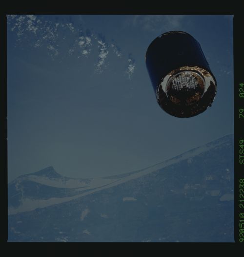
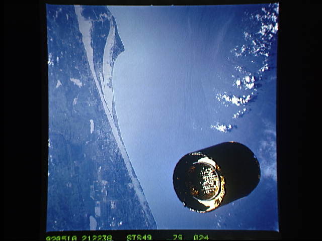
STS049-79-024 - Intelsat over KSC
The Intelsat spacecraft before capture floats over the Kennedy
Space Center, where it and the Shuttle were launched. North is
to the left. [Mainly because of the cloud shadows, this photo
feels better to me with north at the top.] Cape Canaveral juts
out into the Gulf Stream; the Kennedy Space Center shows as a
network of roads extending from the Florida mainland along the
bottom [Rleft sideS?] of the photograph.
In this pre-capture view of the Intelsat VI communications satellite over Kennedy Space Center, Florida (28.0N, 80.0W), the disabled satellite can be seen in a decaying orbit over the KSC launch complex. On the ground, both the older Mercury and Gemini series launch complexes can be seen south of the cape and the Apollo, Skylab and Space Shuttle series launch complexes are north of the cape.
