STS049-151-103
| NASA Photo ID | STS049-151-103 |
| Focal Length | 250mm |
| Date taken | 1992.05.08 |
| Time taken | 20:42:17 GMT |
Resolutions offered for this image:
640 x 480 pixels
640 x 480 pixels
Cloud masks available for this image:
Spacecraft nadir point: 22.1° N, 81.1° W
Photo center point: 22.0° N, 82.5° W
Photo center point by machine learning:
Photo center point: 22.0° N, 82.5° W
Photo center point by machine learning:
Nadir to Photo Center: West
Spacecraft Altitude: 149 nautical miles (276km)
Country or Geographic Name: | CUBA |
Features: | GULF OF BATABANO |
| Features Found Using Machine Learning: | |
Cloud Cover Percentage: | 5 (1-10)% |
Sun Elevation Angle: | 43° |
Sun Azimuth: | 274° |
Camera: | Linhof |
Focal Length: | 250mm |
Camera Tilt: | 30 degrees |
Format: | QX868: Kodak, natural color positive, Ektachrome QX868(5017 emulsion), ASA 64, thin base |
Film Exposure: | Normal |
| Additional Information | |
| Width | Height | Annotated | Cropped | Purpose | Links |
|---|---|---|---|---|---|
| 640 pixels | 480 pixels | No | No | ISD 1 | Download Image |
Download Packaged File
Download a Google Earth KML for this Image
View photo footprint information
Download a GeoTIFF for this photo
Image Caption:
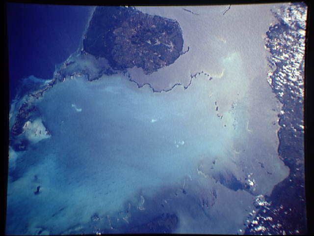
STS49-151-103: Batabano Bay, Cuba Pale blue to greenish colors
indicate the shallow, calcium-carbonate floored water of Batabano
Bay, southwestern Cuba. Sunglint on the straight between the
Isle of Pines and the mainland reflects in orange and pink
colors. This frame is one of several that can be used for an un-
controlled mosaic; the set is perhaps the clearest photography of
the region obtained during the Shuttle Program. Linhof camera,
250mm lens, color film.
