STS048-151-252
| NASA Photo ID | STS048-151-252 |
| Focal Length | 250mm |
| Date taken | 1991.09.14 |
| Time taken | 05:13:46 GMT |


Cloud masks available for this image:
Spacecraft nadir point: 20.7° S, 148.9° E
Photo center point: 21.5° S, 149.5° E
Photo center point by machine learning:
Photo center point: 21.5° S, 149.5° E
Photo center point by machine learning:
Nadir to Photo Center: Southeast
Spacecraft Altitude: 309 nautical miles (572km)
Country or Geographic Name: | AUSTRALIA-Q |
Features: | NORTHUMBERLAND ISLANDS |
| Features Found Using Machine Learning: | |
Cloud Cover Percentage: | 0 (no clouds present) |
Sun Elevation Angle: | 36° |
Sun Azimuth: | 288° |
Camera: | Linhof |
Focal Length: | 250mm |
Camera Tilt: | 11 degrees |
Format: | QX868: Kodak, natural color positive, Ektachrome QX868(5017 emulsion), ASA 64, thin base |
Film Exposure: | Normal |
| Additional Information | |
| Width | Height | Annotated | Cropped | Purpose | Links |
|---|---|---|---|---|---|
| 5112 pixels | 3961 pixels | No | No | Earth From Space collection | Download Image |
| 640 pixels | 495 pixels | No | No | Earth From Space collection | Download Image |
| 640 pixels | 480 pixels | No | No | ISD 1 | Download Image |
Download Packaged File
Download a Google Earth KML for this Image
View photo footprint information
Download a GeoTIFF for this photo
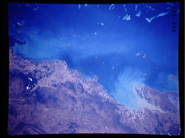
Image Caption: STS048-151-252 Broad Sound Area, Queensland, Australia September 1991
A large sediment plume (light-colored, water borne material) is flowing northward out of the V-shaped Broad Sound along this section of the northeast coast of Queensland. In addition to the obvious sediment plume from Broad Sound, there appears to be a lighter colored, fainter swath of suspended particles located in the Capricorn Channel midway between the mainland and the Great Barrier Reef (part of which is visible in the lower left corner of the image). Three different groups of islands can be seen along this section of Queensland coastline. From northwest to southeast these island groups are Cumberland Islands, Northumberland Islands and the Percy Islands. The darker landscapes away from the coast are low, forested mountains.
A large sediment plume (light-colored, water borne material) is flowing northward out of the V-shaped Broad Sound along this section of the northeast coast of Queensland. In addition to the obvious sediment plume from Broad Sound, there appears to be a lighter colored, fainter swath of suspended particles located in the Capricorn Channel midway between the mainland and the Great Barrier Reef (part of which is visible in the lower left corner of the image). Three different groups of islands can be seen along this section of Queensland coastline. From northwest to southeast these island groups are Cumberland Islands, Northumberland Islands and the Percy Islands. The darker landscapes away from the coast are low, forested mountains.
