STS047-151-618
| NASA Photo ID | STS047-151-618 |
| Focal Length | 90mm |
| Date taken | 1992.09.19 |
| Time taken | 11:02:33 GMT |
Resolutions offered for this image:
640 x 480 pixels
640 x 480 pixels
Cloud masks available for this image:
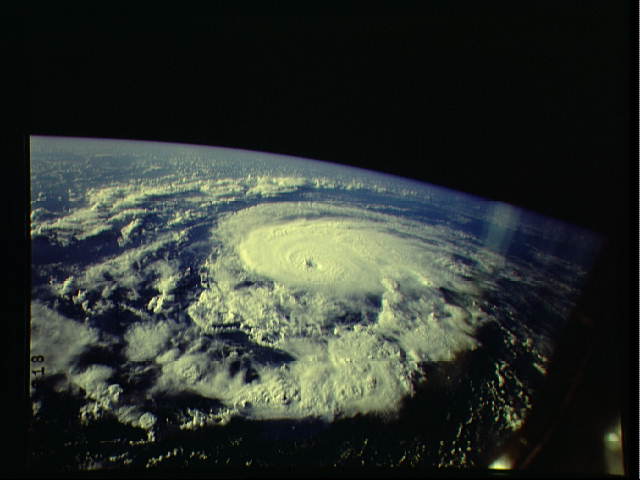
Spacecraft nadir point: 39.1° N, 56.5° W
Photo center point:
Photo center point by machine learning:
Photo center point:
Photo center point by machine learning:
Nadir to Photo Center:
Spacecraft Altitude: 166 nautical miles (307km)
Country or Geographic Name: | ATLANTIC OCEAN |
Features: | HURRICANE NE. BERMUDA |
| Features Found Using Machine Learning: | |
Cloud Cover Percentage: | 65 (51-75)% |
Sun Elevation Angle: | 18° |
Sun Azimuth: | 102° |
Camera: | Linhof |
Focal Length: | 90mm |
Camera Tilt: | High Oblique |
Format: | QX868: Kodak, natural color positive, Ektachrome QX868(5017 emulsion), ASA 64, thin base |
Film Exposure: | Normal |
| Additional Information | |
| Width | Height | Annotated | Cropped | Purpose | Links |
|---|---|---|---|---|---|
| 640 pixels | 480 pixels | No | No | ISD 1 | Download Image |
Download Packaged File
Download a Google Earth KML for this Image
View photo footprint information
Download a GeoTIFF for this photo
Image Caption: Hurricane Bonnie was over the North Atlantic Ocean about 500 miles northeast of Bermuda (39.0N, 56.5W) when this photo was taken. Compare this view with Hurricane Iniki, also photographed on this mission (STS-47-77-058). Bonnie is small but in her prime, having a well defined eye, a tight spiral gyre indicating high wind speeds and numerous thunderheads. Iniki, on the other hand, was decaying when photographed and no longer presented a threat.
