STS045-80-26

| NASA Photo ID | STS045-80-26 |
| Focal Length | 100mm |
| Date taken | 1992.03.27 |
| Time taken | 12:35:28 GMT |

Cloud masks available for this image:
Spacecraft nadir point: 27.8° N, 52.9° E
Photo center point: 27.5° N, 50.0° E
Photo center point by machine learning:
Photo center point: 27.5° N, 50.0° E
Photo center point by machine learning:
Nadir to Photo Center: West
Spacecraft Altitude: 162 nautical miles (300km)
Country or Geographic Name: | SAUDI ARABIA |
Features: | PERSIAN GULF, ABU ALI |
| Features Found Using Machine Learning: | |
Cloud Cover Percentage: | 0 (no clouds present) |
Sun Elevation Angle: | 27° |
Sun Azimuth: | 258° |
Camera: | Hasselblad |
Focal Length: | 100mm |
Camera Tilt: | 47 degrees |
Format: | 5017: Kodak, natural color positive, Ektachrome, X Professional, ASA 64, standard base |
Film Exposure: | Normal |
| Additional Information | |
| Width | Height | Annotated | Cropped | Purpose | Links |
|---|---|---|---|---|---|
| 5700 pixels | 6000 pixels | No | No | Download Image | |
| 500 pixels | 526 pixels | No | No | Download Image | |
| 640 pixels | 480 pixels | No | No | Download Image |
Download Packaged File
Download a Google Earth KML for this Image
View photo footprint information
Download a GeoTIFF for this photo
Image Caption:
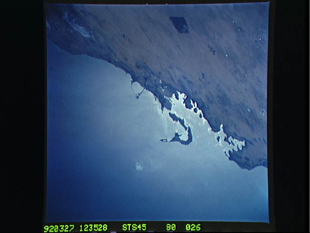
STS045-80-026: Abu Ali Island, Saudi Arabia, Persian Gulf The
sunglint pattern was photographed along the coast of Saudi Arabia
in the area of Abu Ali Island. The bright fringe along the coast
is evidence of oil, deposited after roughly 4 to 6 million bar-
rels of oil were released into the Gulf, off the coast of Kuwait,
during the recent Gulf war. The area north of Abu Ali Island was
heavily impacted by the oil spill.
