STS045-152-11
| NASA Photo ID | STS045-152-11 |
| Focal Length | 250mm |
| Date taken | 1992.03.28 |
| Time taken | 05:04:12 GMT |
Resolutions offered for this image:
640 x 480 pixels
640 x 480 pixels
Cloud masks available for this image:
Spacecraft nadir point: 43.5° N, 143.9° E
Photo center point: 44.0° N, 143.0° E
Photo center point by machine learning:
Photo center point: 44.0° N, 143.0° E
Photo center point by machine learning:
Nadir to Photo Center: Northwest
Spacecraft Altitude: 164 nautical miles (304km)
Country or Geographic Name: | JAPAN |
Features: | VIEW NE HOKAIDO ISLAND |
| Features Found Using Machine Learning: | |
Cloud Cover Percentage: | 0 (no clouds present) |
Sun Elevation Angle: | 37° |
Sun Azimuth: | 231° |
Camera: | Linhof |
Focal Length: | 250mm |
Camera Tilt: | 21 degrees |
Format: | QX868: Kodak, natural color positive, Ektachrome QX868(5017 emulsion), ASA 64, thin base |
Film Exposure: | Normal |
| Additional Information | |
| Width | Height | Annotated | Cropped | Purpose | Links |
|---|---|---|---|---|---|
| 640 pixels | 480 pixels | No | No | ISD 1 | Download Image |
Download Packaged File
Download a Google Earth KML for this Image
View photo footprint information
Download a GeoTIFF for this photo
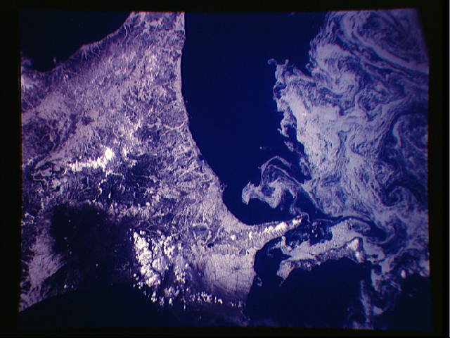
Image Caption:
STS045-152-011: Sea Ice Patterns Along the Coast of Hokkaido,
Japan The northeast coast of Hokkaido and Kunashir Island are
bordered by sea ice in this southwest-looking view, photographed
using the 5-inch format Linhof camera. The sea ice forms a com-
plex pattern of eddies in response to surface water currents and
winds. Photographs such as this aid researchers in describing lo-
cal water current patterns and the effects of wind speed and
direction on the drift of surface material, such as ice or oil.
Kunashir Island lies approximately 16 miles offshore of Hokkaido
and is the southernmost of the Kuril Islands. Historically a
Japanese territory, the island was occupied after World War II by
the U.S.S.R., but an agreement has recently been struck with Rus-
sia to return the island to Japan.
The photograph was taken on the 28th of March (orbit 59) from an
altitude of 158 n. mi. with the Shuttle located at 44! N and
145.5! E.
The northeast coast of Hokkaido and Kunashir Island, Japan (44.0N, 143.0E) are seen bordered by drifting sea ice. The sea ice has formed a complex pattern of eddies in response to surface water currents and winds. Photos of this kind aid researchers in describing local ocean current patterns and the effects of wind speed and direction on the drift of surface material, such as ice floes or oil. Kunashir is the southernmost of the Kuril Islands.
