STS043-74-005
| NASA Photo ID | STS043-74-005 |
| Focal Length | 50mm |
| Date taken | 1991.08.03 |
| Time taken | 19:56:06 GMT |

Cloud masks available for this image:
Spacecraft nadir point: 23.6° N, 125.1° W
Photo center point:
Photo center point by machine learning:
Photo center point:
Photo center point by machine learning:
Nadir to Photo Center:
Spacecraft Altitude: 167 nautical miles (309km)
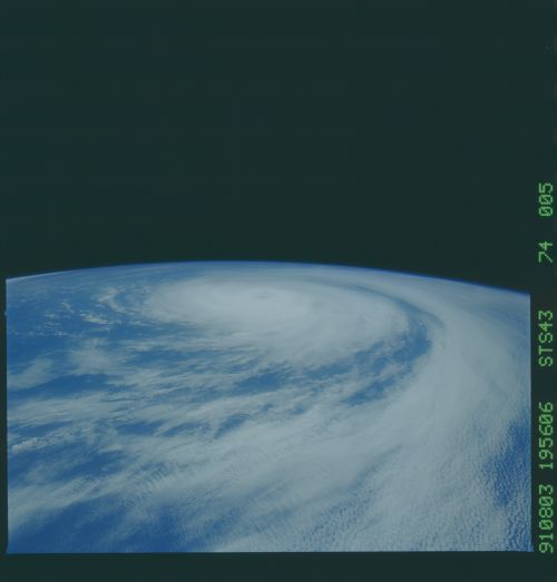
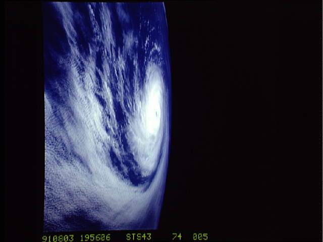
Country or Geographic Name: | PACIFIC OCEAN |
Features: | HURRICANE FEFA |
| Features Found Using Machine Learning: | |
Cloud Cover Percentage: | 80 (76-100)% |
Sun Elevation Angle: | 80° |
Sun Azimuth: | 128° |
Camera: | Hasselblad |
Focal Length: | 50mm |
Camera Tilt: | High Oblique |
Format: | 5017: Kodak, natural color positive, Ektachrome, X Professional, ASA 64, standard base |
Film Exposure: | Normal |
| Additional Information | |
| Width | Height | Annotated | Cropped | Purpose | Links |
|---|---|---|---|---|---|
| 4396 pixels | 4600 pixels | No | No | Download Image | |
| 500 pixels | 523 pixels | No | No | Download Image | |
| 640 pixels | 480 pixels | No | No | Download Image |
Download Packaged File
Download a Google Earth KML for this Image
View photo footprint information
Download a GeoTIFF for this photo
Image Caption: This oblique view of Hurricane Fefa shows the full extent of this storm with a cloud gyre several hundred miles in diameter and an elevated segment around the eye. The elevated segment bordering the eye indicates a tightly formed gyre with high internal wind speeds. At the time of this exposure, Fefa was located between the California coast and Hawaii. Fefa eventually dissipated at sea, failing to make landfall and thus did no property damage.
