STS040-78-88
| NASA Photo ID | STS040-78-88 |
| Focal Length | 50mm |
| Date taken | 1991.06.11 |
| Time taken | 09:33:09 GMT |
Resolutions offered for this image:
3948 x 3940 pixels 639 x 638 pixels 5700 x 6000 pixels 500 x 526 pixels 640 x 480 pixels 3948 x 3940 pixels 909 x 1240 pixels 3993 x 3993 pixels 540 x 737 pixels
3948 x 3940 pixels 639 x 638 pixels 5700 x 6000 pixels 500 x 526 pixels 640 x 480 pixels 3948 x 3940 pixels 909 x 1240 pixels 3993 x 3993 pixels 540 x 737 pixels


Cloud masks available for this image:
Spacecraft nadir point: 26.1° N, 35.0° E
Photo center point: 28.5° N, 34.0° E
Photo center point by machine learning:
Photo center point: 28.5° N, 34.0° E
Photo center point by machine learning:
Nadir to Photo Center: North
Spacecraft Altitude: 153 nautical miles (283km)
Country or Geographic Name: | EGYPT |
Features: | GULF OF SUEZ, AQABA, SINAI |
| Features Found Using Machine Learning: | |
Cloud Cover Percentage: | 5 (1-10)% |
Sun Elevation Angle: | 86° |
Sun Azimuth: | 153° |
Camera: | Hasselblad |
Focal Length: | 50mm |
Camera Tilt: | 45 degrees |
Format: | 5017: Kodak, natural color positive, Ektachrome, X Professional, ASA 64, standard base |
Film Exposure: | Normal |
| Additional Information | |
| Width | Height | Annotated | Cropped | Purpose | Links |
|---|---|---|---|---|---|
| 3948 pixels | 3940 pixels | No | No | Earth From Space collection | Download Image |
| 639 pixels | 638 pixels | No | No | Earth From Space collection | Download Image |
| 5700 pixels | 6000 pixels | No | No | Download Image | |
| 500 pixels | 526 pixels | No | No | Download Image | |
| 640 pixels | 480 pixels | No | No | Download Image | |
| 3948 pixels | 3940 pixels | ReefBase pilot | Download Image | ||
| 909 pixels | 1240 pixels | Yes | Yes | Publisher Request | Download Image |
| 3993 pixels | 3993 pixels | No | No | Download Image | |
| 540 pixels | 737 pixels | Yes | Yes | Publisher Request | Download Image |
Download Packaged File
Download a Google Earth KML for this Image
View photo footprint information
Download a GeoTIFF for this photo
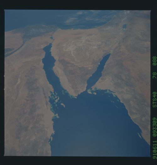
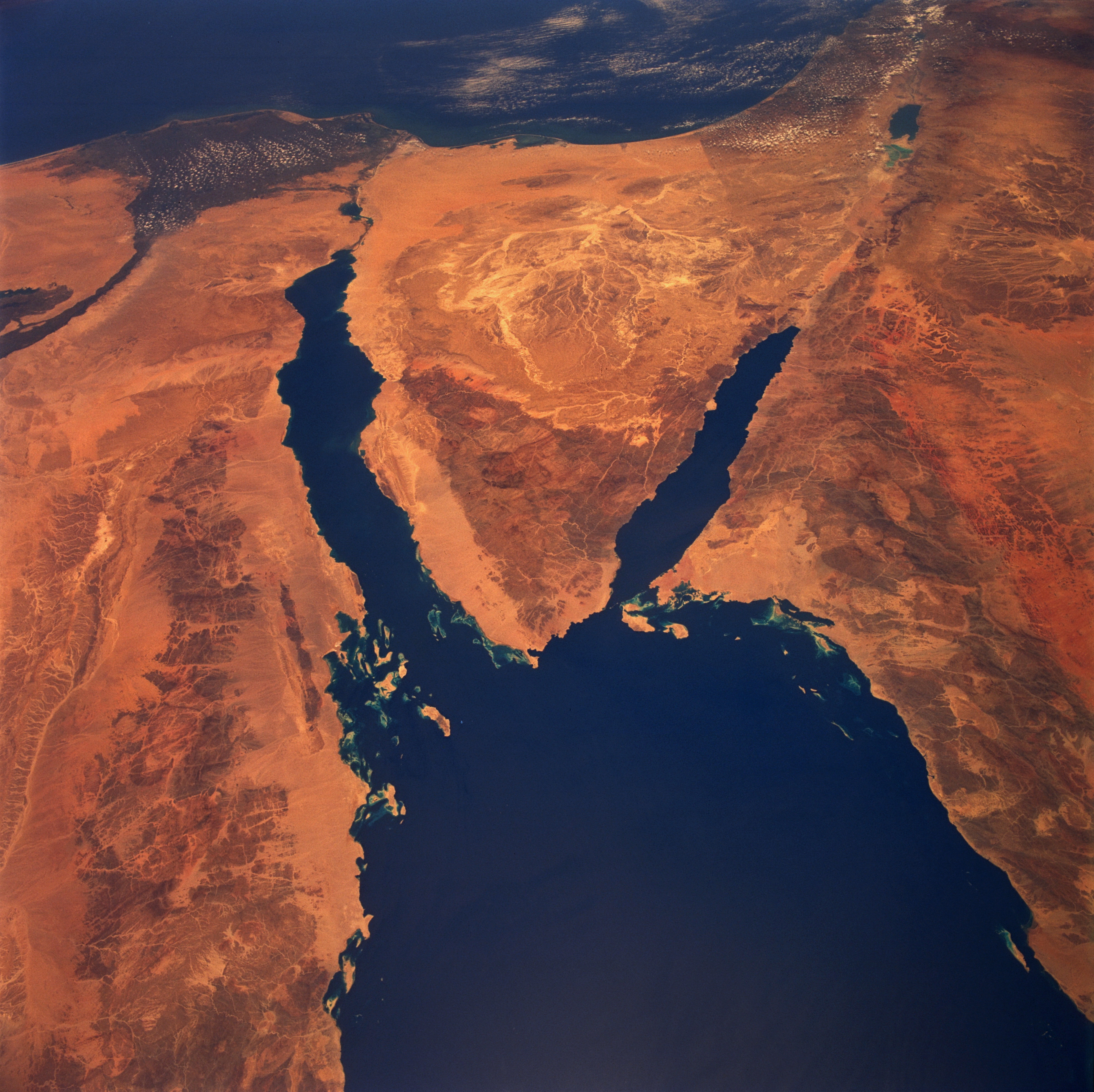
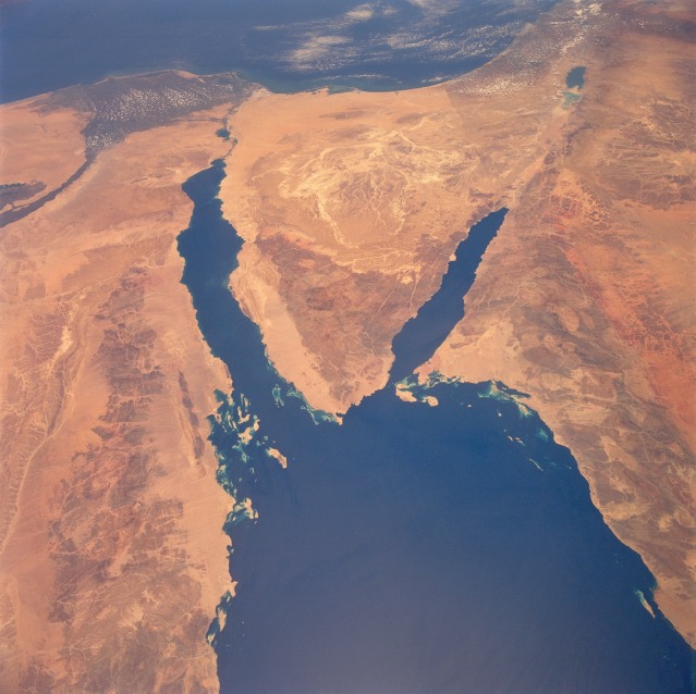
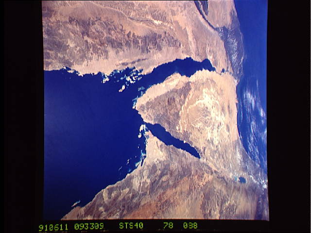
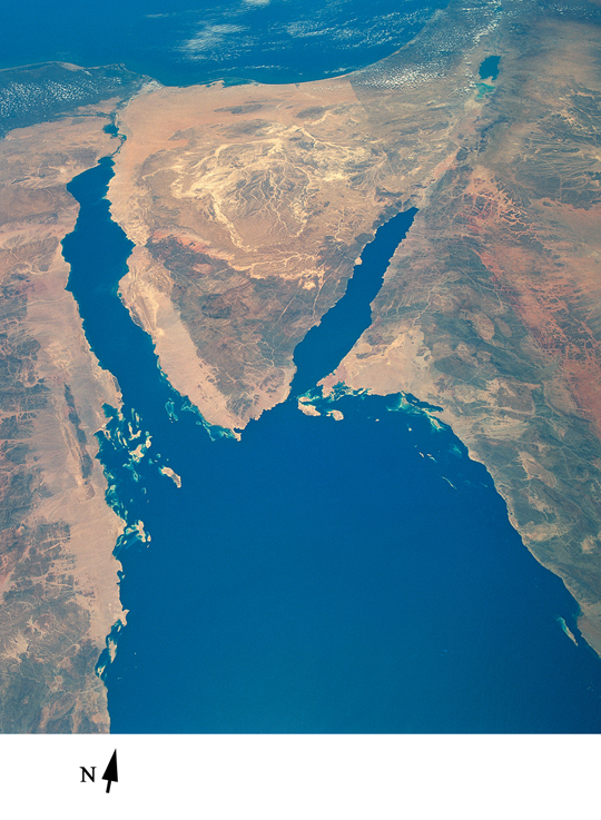
Image Caption: STS040-78-88 Sinai Peninsula, Egypt June 1991
The deep blue waters of the northern Red Sea provide a striking contrast to the sandy landforms (tans) and hills and mountains (browns) of the arid landscape of northeastern Egypt, northwestern Saudi Arabia, southern Israel, and a small part of southwestern Jordan. Elevations for the mountains that ring the northern end of the Red Sea vary from approximately 2000 feet (610 meters) to 3000 feet (910 meters), with many peaks exceeding 6000 feet (1800 meters)--one peak exceeds 8000 feet (2440 meters). The light, more highly reflective pattern in the north-central Sinai is a drainage network of dry stream channels and lakebeds. Other landforms include the northernmost extent of the Nile River and its delta, the Suez Canal (northwest side of the Sinai Peninsula), the Gulf of Aqaba (southeast side of Sinai), the Dead Sea Rift, and the demarcation line in the desert between Israel and Egypt along the eastern edge of the Sinai caused by Israel's emphasis on agriculture. Numerous coral reefs and small islands are visible east of Egypt near the southern tip of the Sinai Peninsula.
The deep blue waters of the northern Red Sea provide a striking contrast to the sandy landforms (tans) and hills and mountains (browns) of the arid landscape of northeastern Egypt, northwestern Saudi Arabia, southern Israel, and a small part of southwestern Jordan. Elevations for the mountains that ring the northern end of the Red Sea vary from approximately 2000 feet (610 meters) to 3000 feet (910 meters), with many peaks exceeding 6000 feet (1800 meters)--one peak exceeds 8000 feet (2440 meters). The light, more highly reflective pattern in the north-central Sinai is a drainage network of dry stream channels and lakebeds. Other landforms include the northernmost extent of the Nile River and its delta, the Suez Canal (northwest side of the Sinai Peninsula), the Gulf of Aqaba (southeast side of Sinai), the Dead Sea Rift, and the demarcation line in the desert between Israel and Egypt along the eastern edge of the Sinai caused by Israel's emphasis on agriculture. Numerous coral reefs and small islands are visible east of Egypt near the southern tip of the Sinai Peninsula.
