STS040-151-128
| NASA Photo ID | STS040-151-128 |
| Focal Length | 90mm |
| Date taken | 1991.06.09 |
| Time taken | 15:21:21 GMT |

Cloud masks available for this image:
Spacecraft nadir point: 38.3° N, 77.8° W
Photo center point: 38.0° N, 78.0° W
Photo center point by machine learning:
Photo center point: 38.0° N, 78.0° W
Photo center point by machine learning:
Nadir to Photo Center: Southwest
Spacecraft Altitude: 154 nautical miles (285km)
Country or Geographic Name: | USA-VIRGINIA |
Features: | CHARLOTTESVILLE AREA |
| Features Found Using Machine Learning: | |
Cloud Cover Percentage: | 5 (1-10)% |
Sun Elevation Angle: | 62° |
Sun Azimuth: | 115° |
Camera: | Linhof |
Focal Length: | 90mm |
Camera Tilt: | 8 degrees |
Format: | QX868: Kodak, natural color positive, Ektachrome QX868(5017 emulsion), ASA 64, thin base |
Film Exposure: | Normal |
| Additional Information | |
| Width | Height | Annotated | Cropped | Purpose | Links |
|---|---|---|---|---|---|
| 5184 pixels | 4096 pixels | No | No | Earth From Space collection | Download Image |
| 640 pixels | 505 pixels | No | No | Earth From Space collection | Download Image |
| 640 pixels | 480 pixels | No | No | ISD 1 | Download Image |
Download Packaged File
Download a Google Earth KML for this Image
View photo footprint information
Download a GeoTIFF for this photo
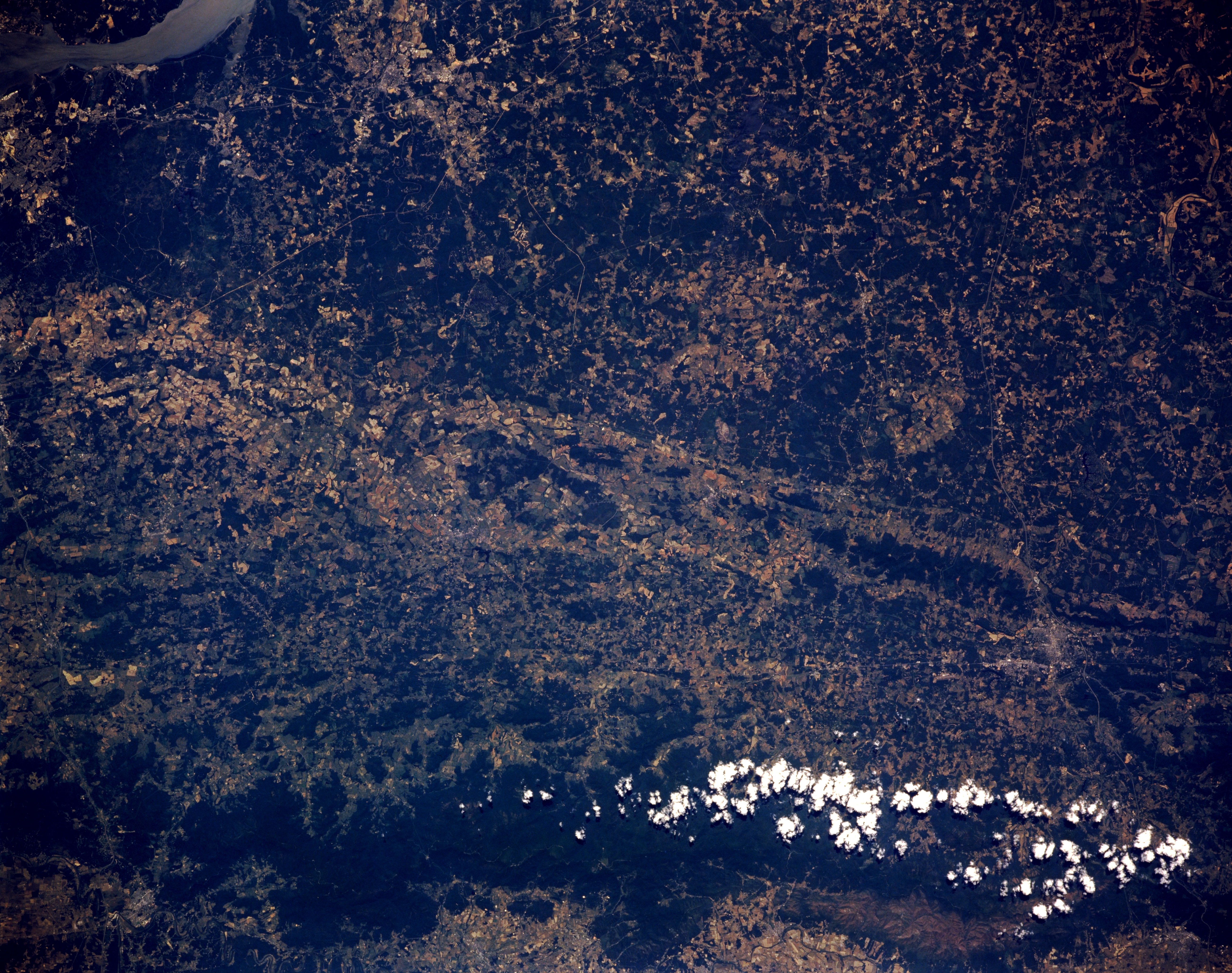
Image Caption: STS040-151-128 Blue Ridge Mountains; Charlottesville, Virginia, U.S.A. June 1991
The boundary separating the Coastal Plain and the Piedmont Region of this section of Virginia can be seen traversing the image from above center left to below center right in this low-oblique image. The upper half of the image shows the gently rolling low forested hills of the Coastal Plain. The lower half of the image shows the Piedmont Region, that is related to the foothills of the Appalachians. The forest-covered Blue Ridge Mountains are visible at the bottom portion of the scene. A small portion of the Potomac River is visible in the upper left of the image. At the right side of the image midway between the clouds over the Blue Ridge Mountains and the Coastal Plain/Piedmont boundary, the city of Charlottesville is barely discernible. The city is located on the Rivanna River, in a Piedmont farm region known for its apples. Charlottesville is the seat of the University of Virginia. Nearby are Monticello, home of the former United States President Thomas Jefferson, and Ashlawn, home of former United States President James Monroe.
The boundary separating the Coastal Plain and the Piedmont Region of this section of Virginia can be seen traversing the image from above center left to below center right in this low-oblique image. The upper half of the image shows the gently rolling low forested hills of the Coastal Plain. The lower half of the image shows the Piedmont Region, that is related to the foothills of the Appalachians. The forest-covered Blue Ridge Mountains are visible at the bottom portion of the scene. A small portion of the Potomac River is visible in the upper left of the image. At the right side of the image midway between the clouds over the Blue Ridge Mountains and the Coastal Plain/Piedmont boundary, the city of Charlottesville is barely discernible. The city is located on the Rivanna River, in a Piedmont farm region known for its apples. Charlottesville is the seat of the University of Virginia. Nearby are Monticello, home of the former United States President Thomas Jefferson, and Ashlawn, home of former United States President James Monroe.
