STS038-84-48
| NASA Photo ID | STS038-84-48 |
| Focal Length | 100mm |
| Date taken | 1990.11.19 |
| Time taken | 03:31:37 GMT |


Cloud masks available for this image:
Spacecraft nadir point: 1.8° N, 112.1° E
Photo center point: 2.5° N, 111.5° E
Photo center point by machine learning:
Photo center point: 2.5° N, 111.5° E
Photo center point by machine learning:
Nadir to Photo Center: Northwest
Spacecraft Altitude: 125 nautical miles (232km)
Country or Geographic Name: | MALAYSIA |
Features: | BORNEO-BERUIT ISLAND |
| Features Found Using Machine Learning: | |
Cloud Cover Percentage: | 80 (76-100)% |
Sun Elevation Angle: | 66° |
Sun Azimuth: | 153° |
Camera: | Hasselblad |
Focal Length: | 100mm |
Camera Tilt: | 24 degrees |
Format: | 5017: Kodak, natural color positive, Ektachrome, X Professional, ASA 64, standard base |
Film Exposure: | Normal |
| Additional Information | |
| Width | Height | Annotated | Cropped | Purpose | Links |
|---|---|---|---|---|---|
| 5700 pixels | 6000 pixels | No | No | Download Image | |
| 500 pixels | 526 pixels | No | No | Download Image | |
| 640 pixels | 480 pixels | No | No | Download Image |
Download Packaged File
Download a Google Earth KML for this Image
View photo footprint information
Download a GeoTIFF for this photo
Image Caption:
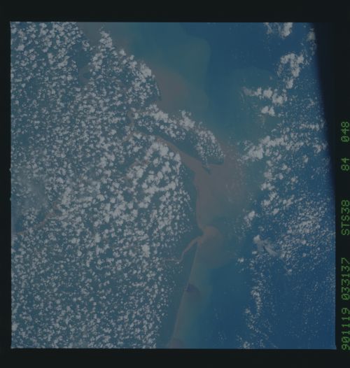
STS038-84-048: RIVER PLUMES, NORTHWEST BORNEO Color visible pho-
tograph of turbidity plumes in the South China Sea along the
north coast of Borneo (Malaysia; 4.7! N, 111.6! E). The photo
was taken during STS-38 on November 19, 1990. The turbidity pat-
terns present clues about local currents and the interaction of
the buoyant river plumes with the denser sea water.
