STS037-152-91
| NASA Photo ID | STS037-152-91 |
| Focal Length | 250mm |
| Date taken | 1991.04.07 |
| Time taken | 05:24:03 GMT |
Resolutions offered for this image:
5631 x 4505 pixels 784 x 1000 pixels 639 x 512 pixels 423 x 540 pixels 640 x 480 pixels 5631 x 4505 pixels
5631 x 4505 pixels 784 x 1000 pixels 639 x 512 pixels 423 x 540 pixels 640 x 480 pixels 5631 x 4505 pixels

Cloud masks available for this image:
Spacecraft nadir point: 28.4° N, 47.8° E
Photo center point: 29.5° N, 48.5° E
Photo center point by machine learning:
Photo center point: 29.5° N, 48.5° E
Photo center point by machine learning:
Nadir to Photo Center: Northeast
Spacecraft Altitude: 247 nautical miles (457km)
Country or Geographic Name: | KUWAIT |
Features: | FAYLAKA I.-KUWAIT FIRES |
| Features Found Using Machine Learning: | |
Cloud Cover Percentage: | 0 (no clouds present) |
Sun Elevation Angle: | 36° |
Sun Azimuth: | 104° |
Camera: | Linhof |
Focal Length: | 250mm |
Camera Tilt: | 18 degrees |
Format: | QX868: Kodak, natural color positive, Ektachrome QX868(5017 emulsion), ASA 64, thin base |
Film Exposure: | Normal |
| Additional Information | |
| Width | Height | Annotated | Cropped | Purpose | Links |
|---|---|---|---|---|---|
| 5631 pixels | 4505 pixels | No | No | Earth From Space collection | Download Image |
| 784 pixels | 1000 pixels | No | Yes | Earth From Space collection | Download Image |
| 639 pixels | 512 pixels | No | No | Earth From Space collection | Download Image |
| 423 pixels | 540 pixels | No | Yes | Earth From Space collection | Download Image |
| 640 pixels | 480 pixels | No | No | ISD 1 | Download Image |
| 5631 pixels | 4505 pixels | Download Image |
Download Packaged File
Download a Google Earth KML for this Image
View photo footprint information
Download a GeoTIFF for this photo
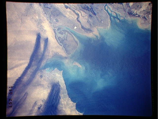
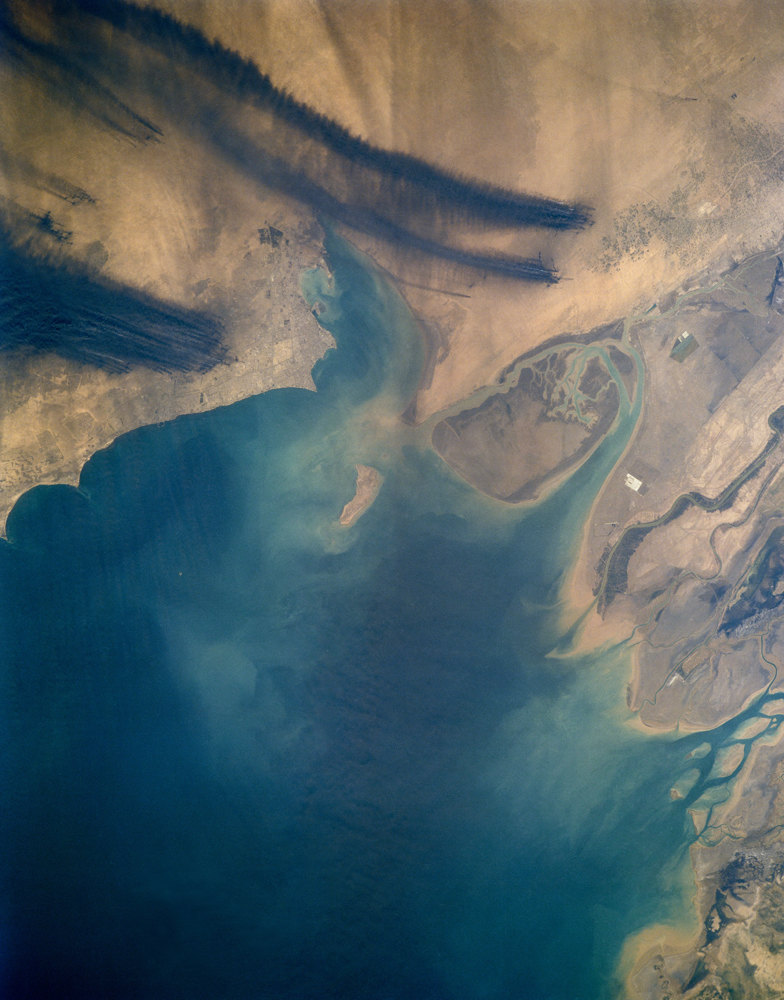
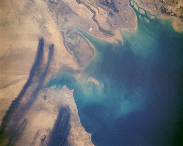
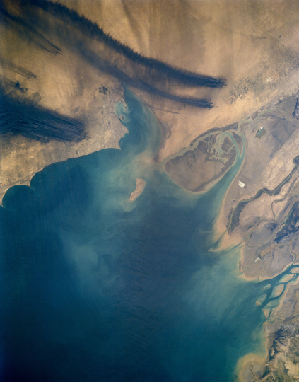
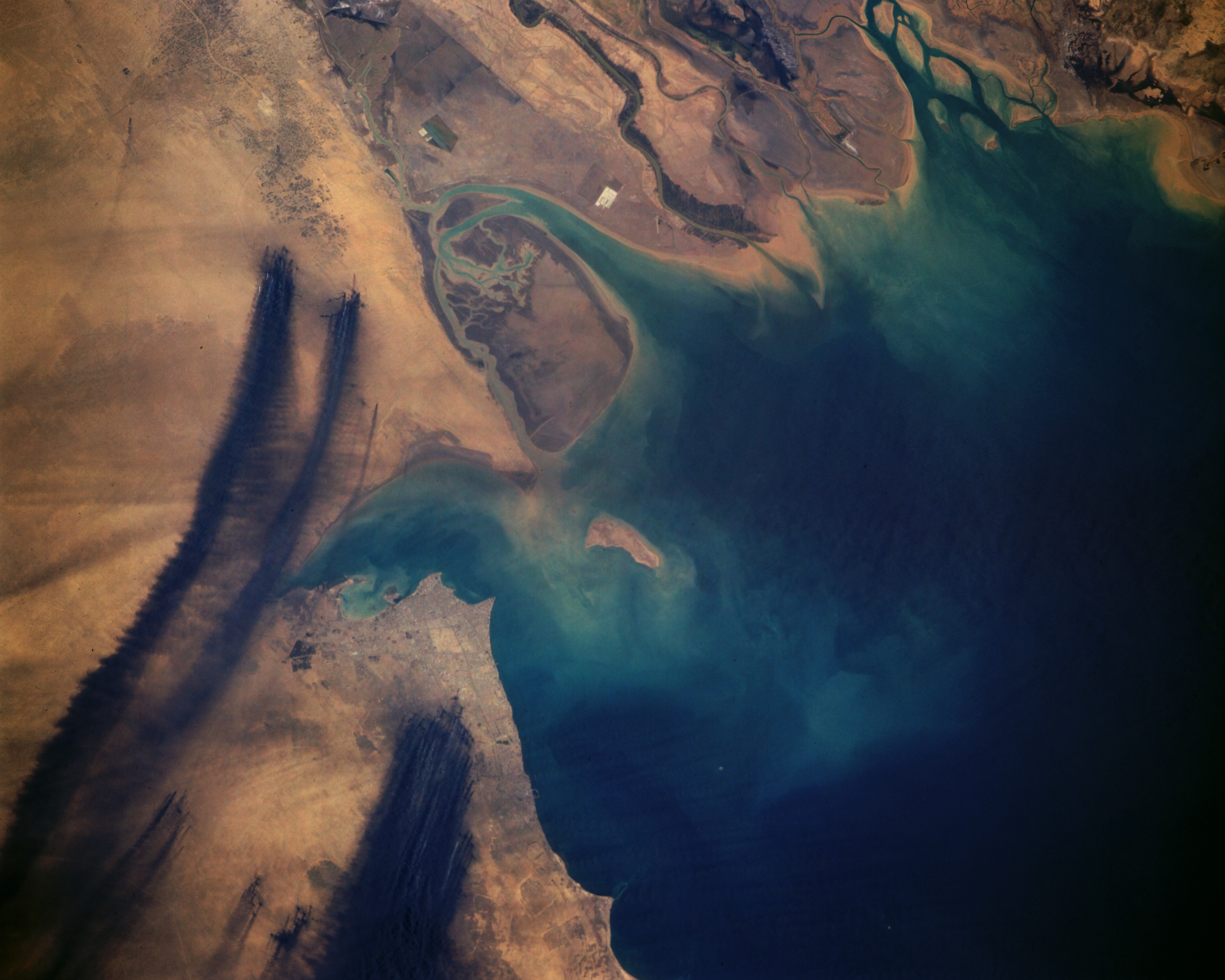
Image Caption: STS037-152-091 Oil Well Fires and Smoke, Kuwait April 1991
The effects of Iraq dictator Saddam Hussein's setting fire to the oil wells in Kuwait during February 1991 is graphically captured in this near-vertical photograph of the northwestern end of the Persian Gulf. The black smoke plumes of more than 700 individual oil well fires are being blown to the south. Kuwait City is located on the south side of Kuwait Bay, southwest of the Tigris-Euphrates Delta. Fortunately, the oil well fires were extinguished in much less time than had been originally predicted, and the environmental damage created by the fires and smoke was mostly confined to the immediate region around the northwestern Persian Gulf. (Refer to STS-046-074-094 for a photograph of the same area to see how quickly the desert is reclaiming the land in this region.)
The effects of Iraq dictator Saddam Hussein's setting fire to the oil wells in Kuwait during February 1991 is graphically captured in this near-vertical photograph of the northwestern end of the Persian Gulf. The black smoke plumes of more than 700 individual oil well fires are being blown to the south. Kuwait City is located on the south side of Kuwait Bay, southwest of the Tigris-Euphrates Delta. Fortunately, the oil well fires were extinguished in much less time than had been originally predicted, and the environmental damage created by the fires and smoke was mostly confined to the immediate region around the northwestern Persian Gulf. (Refer to STS-046-074-094 for a photograph of the same area to see how quickly the desert is reclaiming the land in this region.)
