STS036-152-16
| NASA Photo ID | STS036-152-16 |
| Focal Length | 250mm |
| Date taken | 1990.03.02 |
| Time taken | 18:21:03 GMT |
Resolutions offered for this image:
640 x 480 pixels
640 x 480 pixels
Cloud masks available for this image:
Spacecraft nadir point: 46.8° N, 120.2° W
Photo center point: 46.0° N, 122.0° W
Photo center point by machine learning:
Photo center point: 46.0° N, 122.0° W
Photo center point by machine learning:
Nadir to Photo Center: West
Spacecraft Altitude: 125 nautical miles (231km)
Country or Geographic Name: | USA-WASHINGTON |
Features: | MT. ST. HELENS, MT. ADAMS |
| Features Found Using Machine Learning: | |
Cloud Cover Percentage: | 0 (no clouds present) |
Sun Elevation Angle: | 31° |
Sun Azimuth: | 147° |
Camera: | Linhof |
Focal Length: | 250mm |
Camera Tilt: | 43 degrees |
Format: | QX868: Kodak, natural color positive, Ektachrome QX868(5017 emulsion), ASA 64, thin base |
Film Exposure: | Normal |
| Additional Information | |
| Width | Height | Annotated | Cropped | Purpose | Links |
|---|---|---|---|---|---|
| 640 pixels | 480 pixels | No | No | ISD 1 | Download Image |
Download Packaged File
Download a Google Earth KML for this Image
View photo footprint information
Download a GeoTIFF for this photo
Image Caption:
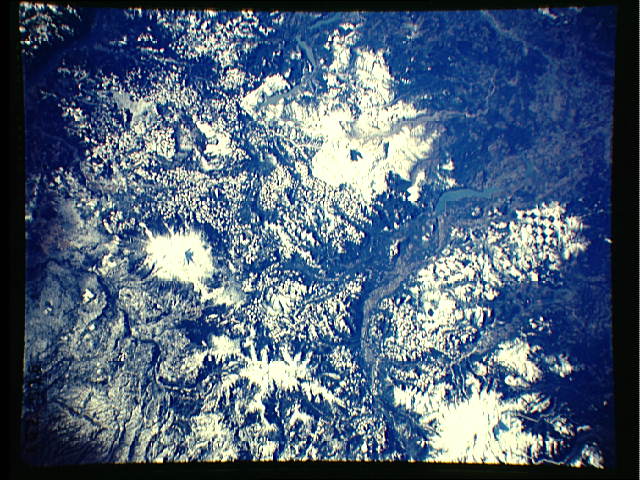
S36-152-016: Mount St. Helens, Washington This near-vertical
view shows Mount St. Helens. Mount Adams can be seen to the east
(right) of Mount St. Helens. Coldwater Reservoir is visible to
the northwest (left) of the volcano. Forest-clearing patches are
also visible, scattered throughout the scene.
Minor eruptions of ash have been occurring at Mount St. Helens
since late last year. These ash eruptions are limited to the
central crater or the flanks of the mountain. In this scene,
greyish-brown ash can be seen in the white snow extending outward
from the volcanic crater, proceeding westward to the south of
Spirit Lake into the Toutle River Valley. Much of the ash and
silt deposits can be seen backing up near a large dam that is be-
ing built, on the Toutle River west of the mountain. The Toutle
River, at the bottom left of the view, is much more sediment-
laden than numerous other streams visible in the scene.
When this scene was photographed by the STS-36 crew, the weather
in the Pacific Northwest had been unusually warm. Snow cover was
prevelant at altitudes above 5000 feet. Melting of snow cover
above the 5000-foot level had been occurring, which may also ex-
plain the greyish-brown streak descending from Mount St. Helens
into the Toutle River Valley.
