STS036-151-171
| NASA Photo ID | STS036-151-171 |
| Focal Length | 250mm |
| Date taken | 1990.03.02 |
| Time taken | 11:14:45 GMT |
Resolutions offered for this image:
640 x 480 pixels
640 x 480 pixels
Cloud masks available for this image:
Spacecraft nadir point: 22.6° S, 34.8° E
Photo center point: 22.0° S, 35.0° E
Photo center point by machine learning:
Photo center point: 22.0° S, 35.0° E
Photo center point by machine learning:
Nadir to Photo Center: North
Spacecraft Altitude: 132 nautical miles (244km)
Country or Geographic Name: | MOZAMBIQUE |
Features: | BAZARUTO I, VILANCULOS |
| Features Found Using Machine Learning: | |
Cloud Cover Percentage: | 25 (11-25)% |
Sun Elevation Angle: | 65° |
Sun Azimuth: | 305° |
Camera: | Linhof |
Focal Length: | 250mm |
Camera Tilt: | 16 degrees |
Format: | QX868: Kodak, natural color positive, Ektachrome QX868(5017 emulsion), ASA 64, thin base |
Film Exposure: | Normal |
| Additional Information | |
| Width | Height | Annotated | Cropped | Purpose | Links |
|---|---|---|---|---|---|
| 640 pixels | 480 pixels | No | No | ISD 1 | Download Image |
Download Packaged File
Download a Google Earth KML for this Image
View photo footprint information
Download a GeoTIFF for this photo
Image Caption:
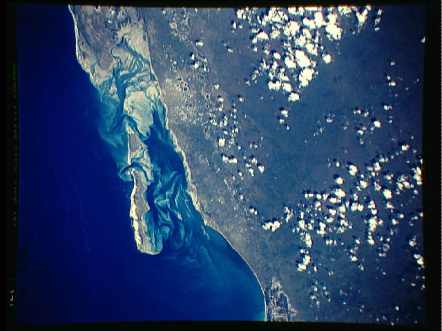
S36-151-171: Bazaruto Island, Mozambique coast, southeast Africa
Bazaruto Island was for many years before the Mozambican revolu-
tion in the mid-70s, an outdoor playground for foreigners, espe-
cially South Africans who would fly and boat to this unspoiled,
crystal clear tropical lagoon. Fishing, boating, and scuba diving
are excellent in the area. Tourism of this type is being en-
couraged again for the first time in many years. At low tide,
the shallow submarine sandbanks in the lagoon inshore of Bazaruto
appear as brilliant swaths whose movement can be monitored from
space. The banks are generated by the ebb and flow of tides, so
that banks appear inshore and on the seaward side of lagoon
mouths. Experience from the Bahamas suggests that the sandbanks
are stable until a major storm, usually a hurricane, passes near-
by producing outsize waves which reach greater than normal
depths.
