STS036-151-101
| NASA Photo ID | STS036-151-101 |
| Focal Length | 250mm |
| Date taken | 1990.__.__ |
| Time taken | GMT |

Cloud masks available for this image:
Spacecraft nadir point:
Photo center point: 31.0° N, 30.5° E
Photo center point by machine learning:
Photo center point: 31.0° N, 30.5° E
Photo center point by machine learning:
Nadir to Photo Center:
Spacecraft Altitude: nautical miles (0km)
Country or Geographic Name: | EGYPT |
Features: | NILE R/DELTA, AGR. AREA |
| Features Found Using Machine Learning: | |
Cloud Cover Percentage: | 0 (no clouds present) |
Sun Elevation Angle: | ° |
Sun Azimuth: | ° |
Camera: | Linhof |
Focal Length: | 250mm |
Camera Tilt: | Near Vertical |
Format: | QX868: Kodak, natural color positive, Ektachrome QX868(5017 emulsion), ASA 64, thin base |
Film Exposure: | Normal |
| Additional Information | |
| Width | Height | Annotated | Cropped | Purpose | Links |
|---|---|---|---|---|---|
| 640 pixels | 480 pixels | No | No | ISD 1 | Download Image |
| 2258 pixels | 2828 pixels | No | No | Download Image |
Download Packaged File
Download a Google Earth KML for this Image
View photo footprint information
Download a GeoTIFF for this photo
Image Caption:
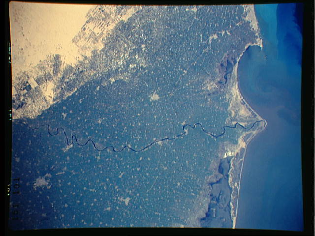
S36-151-101: Nile Delta (See also 152-088/9.) Good atmospheric
clarity, no dust. The many towns and villages of the Nile Delta
proper, from just north of Cairo to Alexandria. The Nile branch
here is the Rosetta or the western Nile. Indeed, you guys caught
Aboukir Bay as well, where Napolean lost his fleet (the first
time) to dear olde Nelson, and where the LUOrient blew up. If
you look closely, you will see where Nelson ran his fleet around
the the point of Aboukir Bay on the extreme left of the frame and
thence down the landward side of the Frogs. Also note the dif-
ferent type of irrigation west of the Rosetta Nile here . . .
itUs canal, surface-fed irrigation instead of the center-pivot
form that you can see east of the Damietta Nile on frame 152-088.
It was a wonderful victory for the British, like I said earlier
on.
