STS035-501-9

| NASA Photo ID | STS035-501-9 |
| Focal Length | mm |
| Date taken | 1990.12.__ |
| Time taken | GMT |
Resolutions offered for this image:
3895 x 4030 pixels 618 x 639 pixels 5854 x 5775 pixels 500 x 493 pixels
3895 x 4030 pixels 618 x 639 pixels 5854 x 5775 pixels 500 x 493 pixels
Cloud masks available for this image:
Spacecraft nadir point:
Photo center point: 29.0° S, 137.5° E
Photo center point by machine learning:
Photo center point: 29.0° S, 137.5° E
Photo center point by machine learning:
Nadir to Photo Center:
Spacecraft Altitude: nautical miles (0km)
Country or Geographic Name: | AUSTRALIA-SA |
Features: | LAKE EYRE |
| Features Found Using Machine Learning: | |
Cloud Cover Percentage: | 0 (no clouds present) |
Sun Elevation Angle: | ° |
Sun Azimuth: | ° |
Camera: | |
Focal Length: | mm |
Camera Tilt: | Low Oblique |
Format: | |
Film Exposure: | |
| Additional Information | |
| Width | Height | Annotated | Cropped | Purpose | Links |
|---|---|---|---|---|---|
| 3895 pixels | 4030 pixels | No | No | Earth From Space collection | Download Image |
| 618 pixels | 639 pixels | No | No | Earth From Space collection | Download Image |
| 5854 pixels | 5775 pixels | No | No | Download Image | |
| 500 pixels | 493 pixels | No | No | Download Image |
Download Packaged File
Download a Google Earth KML for this Image
View photo footprint information
Download a GeoTIFF for this photo
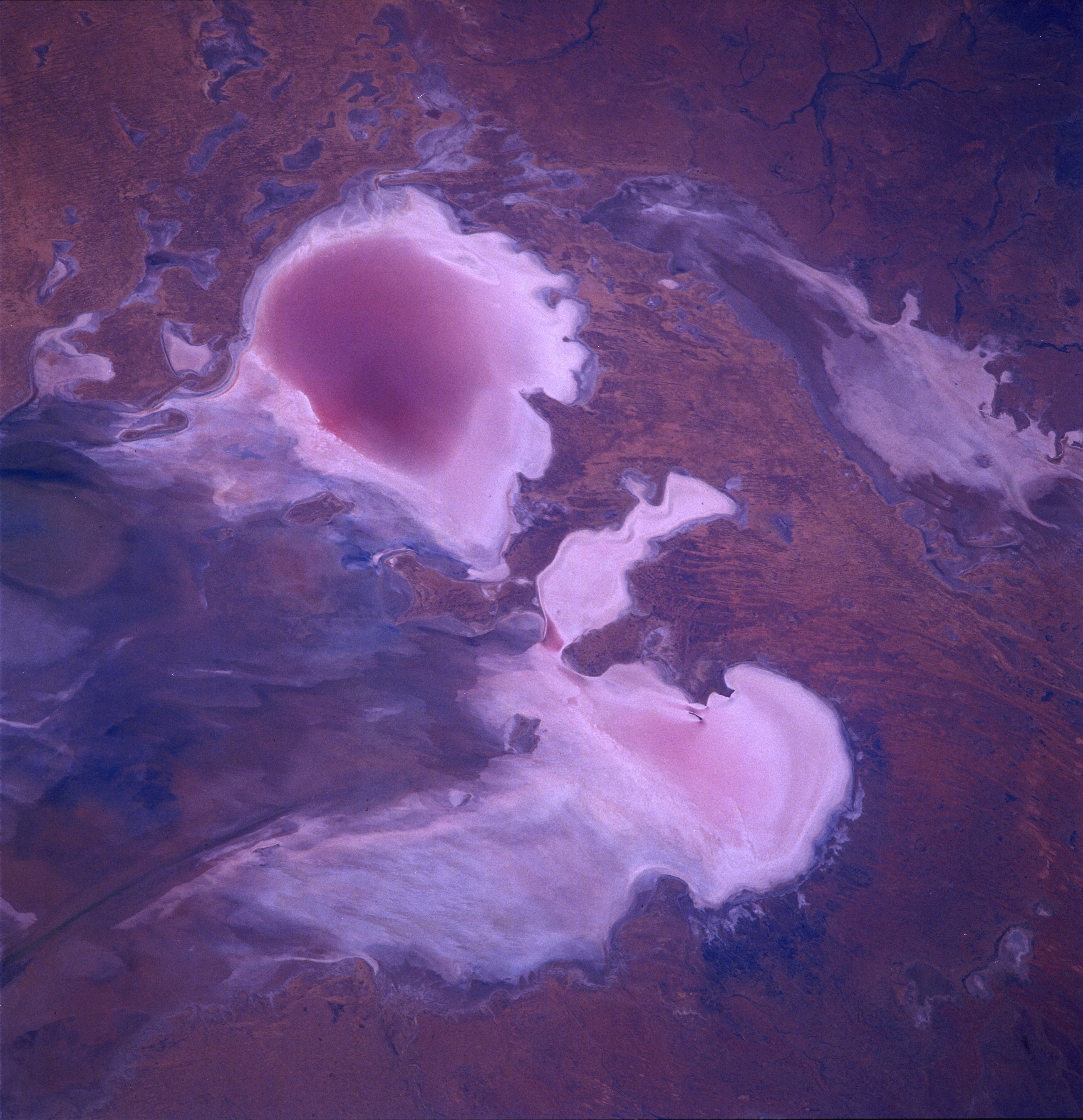
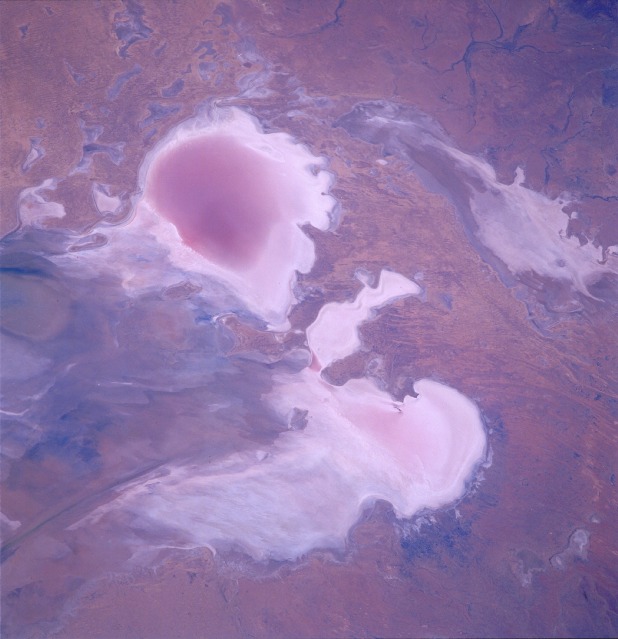
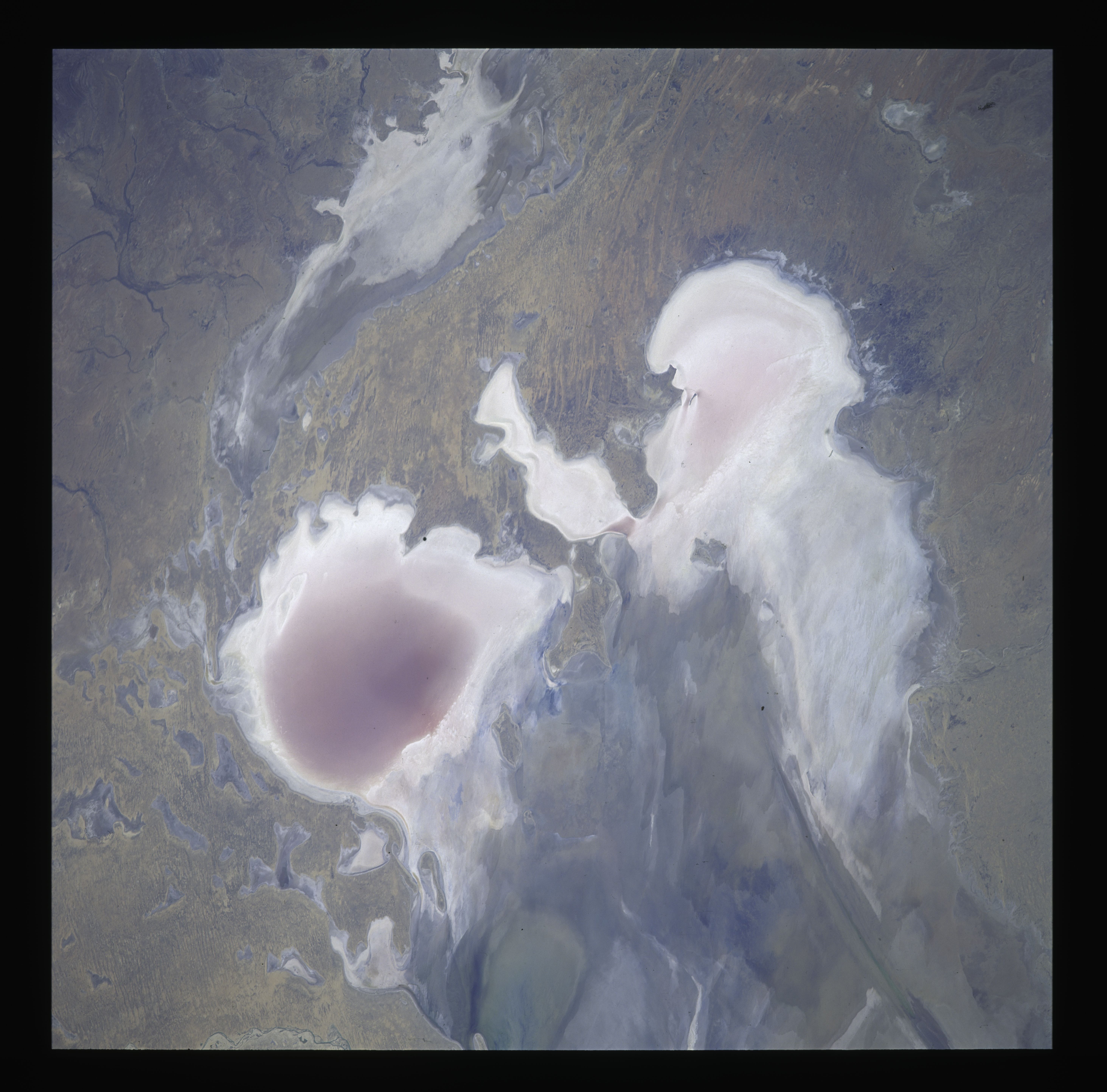
Image Caption: STS035-501-009 Lake Eyre, South Australia December 1990
Lake Eyre, located in the arid interior of south-central Australia, is one of the largest areas of internal drainage in the world. The lake, which receives its principal water drainage from southwestern Queensland, consists of two distinct, but interrelated, basins. The much larger north basin consists of two large, highly reflective, normally dry lakebeds--eastern Madigan Bay and western Belt Bay. The prominent color change in the Madigan Bay lobe indicates the presence of some water at the time the photograph was taken. The much smaller, white appendage extending southward from Belt Bay is Jackboot Bay. The elongated south basin of Lake Eyre is normally dry with a highly reflective encrustation of salt and sand.
Lake Eyre, located in the arid interior of south-central Australia, is one of the largest areas of internal drainage in the world. The lake, which receives its principal water drainage from southwestern Queensland, consists of two distinct, but interrelated, basins. The much larger north basin consists of two large, highly reflective, normally dry lakebeds--eastern Madigan Bay and western Belt Bay. The prominent color change in the Madigan Bay lobe indicates the presence of some water at the time the photograph was taken. The much smaller, white appendage extending southward from Belt Bay is Jackboot Bay. The elongated south basin of Lake Eyre is normally dry with a highly reflective encrustation of salt and sand.
