STS033-92-72

| NASA Photo ID | STS033-92-72 |
| Focal Length | 250mm |
| Date taken | 1989.11.26 |
| Time taken | 08:07:04 GMT |
Resolutions offered for this image:
1536 x 1536 pixels 639 x 639 pixels 5700 x 5900 pixels 500 x 518 pixels 640 x 480 pixels
1536 x 1536 pixels 639 x 639 pixels 5700 x 5900 pixels 500 x 518 pixels 640 x 480 pixels

Cloud masks available for this image:
Spacecraft nadir point: 20.7° N, 92.9° E
Photo center point: 21.0° N, 92.5° E
Photo center point by machine learning:
Photo center point: 21.0° N, 92.5° E
Photo center point by machine learning:
Nadir to Photo Center: Northwest
Spacecraft Altitude: 142 nautical miles (263km)
Country or Geographic Name: | MYANMAR (BURMA) |
Features: | MAYU RIVER-MOUNTAINS |
| Features Found Using Machine Learning: | |
Cloud Cover Percentage: | 10 (1-10)% |
Sun Elevation Angle: | 34° |
Sun Azimuth: | 224° |
Camera: | Hasselblad |
Focal Length: | 250mm |
Camera Tilt: | 12 degrees |
Format: | 2443: Kodak Aerochrome 2443, color IR, thin base, EA-5 process thru June 1999, E-6 process afterward |
Film Exposure: | Normal |
| Additional Information | |
| Width | Height | Annotated | Cropped | Purpose | Links |
|---|---|---|---|---|---|
| 1536 pixels | 1536 pixels | No | No | Earth From Space collection | Download Image |
| 639 pixels | 639 pixels | No | No | Earth From Space collection | Download Image |
| 5700 pixels | 5900 pixels | No | No | Download Image | |
| 500 pixels | 518 pixels | No | No | Download Image | |
| 640 pixels | 480 pixels | No | No | Download Image |
Download Packaged File
Download a Google Earth KML for this Image
View photo footprint information
Download a GeoTIFF for this photo
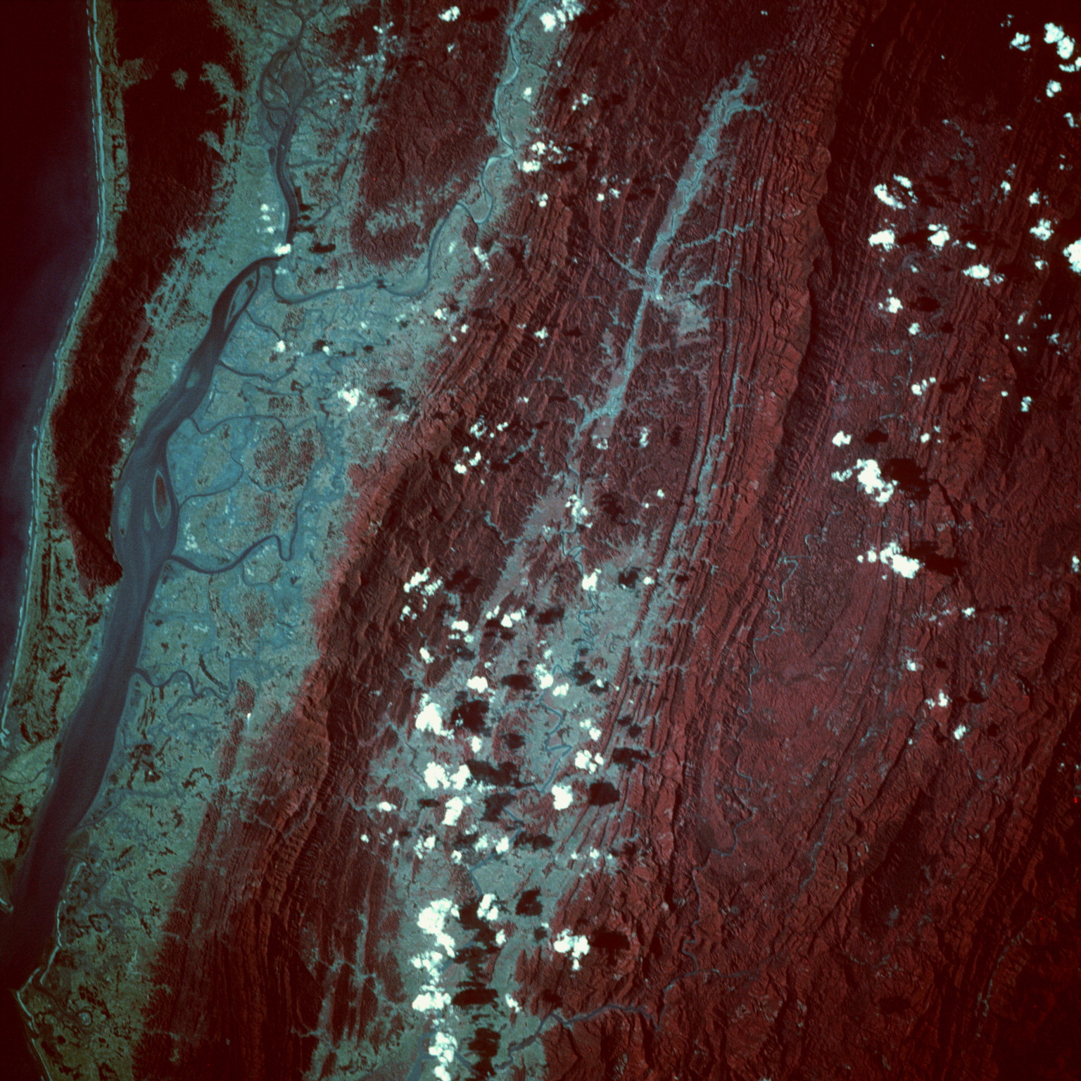
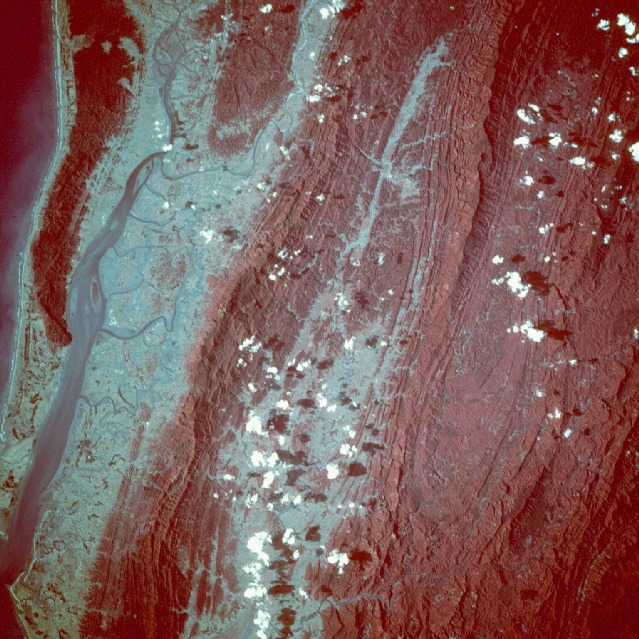
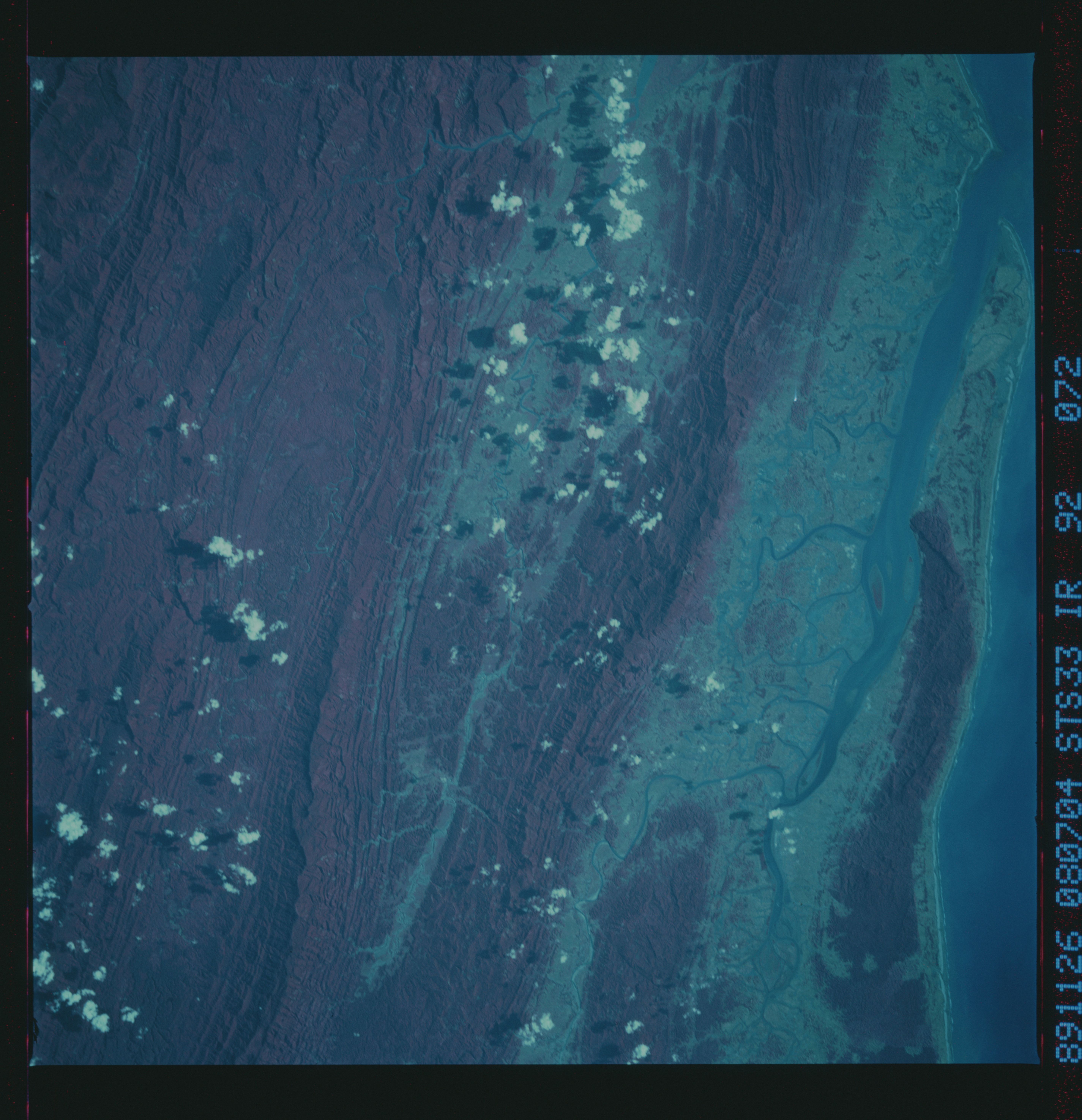
Image Caption: STS033-92-72 Mayu and Naf River Valleys, Myanmar/Bangladesh November 1989
This color-infrared near-vertical view shows the mouth of the Naf River (left edge) and the upper Mayu River valley (center). The western linear folds of the Arakan Range separate the two river valleys. The water on the far left center and upper left of the image is the Bay of Bengal. The Naf River Valley is mostly an estuary of marsh and swamplands inter-dispersed with agricultural lands. The river course follows the Bangladesh-Myanmar border. The Mayu River has a larger catchment area, and here we see its upstream section; it continues to drain southward (bottom center) before its mouth widens into the Bay of Bengal just north of the city of Sittwe (not seen in this photograph). Forests cover most of the high slopes of the mountains with grasslands mixed with agriculture covering the lower slopes. Despite the dense forest cover of the hills and mountains, anticlinal and synclinal structural patterns are shown clearly. The Arakan Range is part of a long chain of ranges that form at the margin of the Indian plate and the Asian plate.
This color-infrared near-vertical view shows the mouth of the Naf River (left edge) and the upper Mayu River valley (center). The western linear folds of the Arakan Range separate the two river valleys. The water on the far left center and upper left of the image is the Bay of Bengal. The Naf River Valley is mostly an estuary of marsh and swamplands inter-dispersed with agricultural lands. The river course follows the Bangladesh-Myanmar border. The Mayu River has a larger catchment area, and here we see its upstream section; it continues to drain southward (bottom center) before its mouth widens into the Bay of Bengal just north of the city of Sittwe (not seen in this photograph). Forests cover most of the high slopes of the mountains with grasslands mixed with agriculture covering the lower slopes. Despite the dense forest cover of the hills and mountains, anticlinal and synclinal structural patterns are shown clearly. The Arakan Range is part of a long chain of ranges that form at the margin of the Indian plate and the Asian plate.
