STS032-90-86
| NASA Photo ID | STS032-90-86 |
| Focal Length | 250mm |
| Date taken | 1990.01.17 |
| Time taken | 16:53:47 GMT |

Cloud masks available for this image:
Spacecraft nadir point: 24.3° S, 53.2° W
Photo center point: 24.0° S, 54.0° W
Photo center point by machine learning:
Photo center point: 24.0° S, 54.0° W
Photo center point by machine learning:
Nadir to Photo Center: West
Spacecraft Altitude: 180 nautical miles (333km)
Country or Geographic Name: | BRAZIL |
Features: | RIO PARANA, RIO PIQUIRI |
| Features Found Using Machine Learning: | |
Cloud Cover Percentage: | 50 (26-50)% |
Sun Elevation Angle: | 73° |
Sun Azimuth: | 278° |
Camera: | Hasselblad |
Focal Length: | 250mm |
Camera Tilt: | 16 degrees |
Format: | 5036: Kodak, natural color positive, Ektachrome 5036,200 Professional, ASA 200, stand |
Film Exposure: | Normal |
| Additional Information | |
| Width | Height | Annotated | Cropped | Purpose | Links |
|---|---|---|---|---|---|
| 5700 pixels | 5900 pixels | No | No | Download Image | |
| 500 pixels | 518 pixels | No | No | Download Image | |
| 640 pixels | 480 pixels | No | No | Download Image |
Download Packaged File
Download a Google Earth KML for this Image
View photo footprint information
Download a GeoTIFF for this photo
Image Caption:
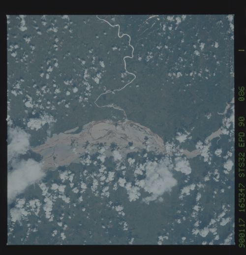
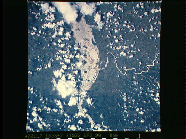
Rio Paran, Rio Piquiri
The Rio Piquiri (1) is seen in this oblique west-looking view as
it enters the flood-swollen Rio Paran near the city of Guaira,
Brazil. Heavy summer rains have produced the great width of the
Paran as it flows southward toward the Rio de la Plata and the
Atlantic Ocean. (S32-90-086)
