STS030-73-87
| NASA Photo ID | STS030-73-87 |
| Focal Length | 50mm |
| Date taken | 1989.05.__ |
| Time taken | GMT |


Cloud masks available for this image:
Spacecraft nadir point:
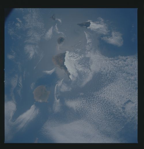
Photo center point: 28.5° N, 16.0° W
Photo center point by machine learning:
Photo center point: 28.5° N, 16.0° W
Photo center point by machine learning:
Nadir to Photo Center:
Spacecraft Altitude: nautical miles (0km)
Country or Geographic Name: | CANARY ISLANDS |
Features: | GRAN CANARIA, TENERIFE |
| Features Found Using Machine Learning: | |
Cloud Cover Percentage: | 60 (51-75)% |
Sun Elevation Angle: | ° |
Sun Azimuth: | ° |
Camera: | Hasselblad |
Focal Length: | 50mm |
Camera Tilt: | Near Vertical |
Format: | 5017: Kodak, natural color positive, Ektachrome, X Professional, ASA 64, standard base |
Film Exposure: | Normal |
| Additional Information | |
| Width | Height | Annotated | Cropped | Purpose | Links |
|---|---|---|---|---|---|
| 5700 pixels | 5900 pixels | No | No | Download Image | |
| 500 pixels | 518 pixels | No | No | Download Image | |
| 640 pixels | 480 pixels | No | No | Download Image |
Download Packaged File
Download a Google Earth KML for this Image
View photo footprint information
Download a GeoTIFF for this photo
Image Caption: This nearly vertical view of the Canary Archipelago (28.5N, 16.5W) shows five of the seven islands: Grand Canary, Tenerife, Gomera, Hierro and La Palma. The largest island in view is Tenerife. Island cloud wakes evident in this photo are the result of southerly winds giving rise to cloud banks on the lee side especially on Tenerife which has the highest volcanic peaks. Island water wakes and internal waves are also evident but not as apparent.
