STS030-152-68
| NASA Photo ID | STS030-152-68 |
| Focal Length | 90mm |
| Date taken | 1989.05.06 |
| Time taken | 19:12:46 GMT |
Resolutions offered for this image:
640 x 480 pixels
640 x 480 pixels
Cloud masks available for this image:
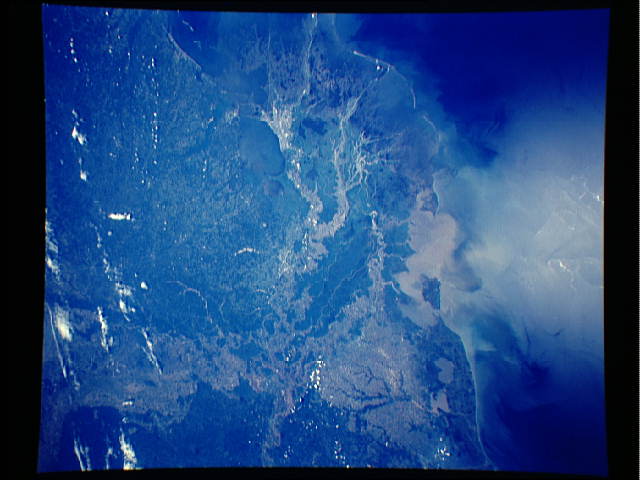
Spacecraft nadir point: 28.9° N, 91.1° W
Photo center point: 30.0° N, 91.0° W
Photo center point by machine learning:
Photo center point: 30.0° N, 91.0° W
Photo center point by machine learning:
Nadir to Photo Center: North
Spacecraft Altitude: 173 nautical miles (320km)
Country or Geographic Name: | USA-LOUISIANA |
Features: | NEW ORLEANS, GULF COAST |
| Features Found Using Machine Learning: | |
Cloud Cover Percentage: | 10 (1-10)% |
Sun Elevation Angle: | 69° |
Sun Azimuth: | 237° |
Camera: | Linhof |
Focal Length: | 90mm |
Camera Tilt: | 21 degrees |
Format: | 5017: Kodak, natural color positive, Ektachrome, X Professional, ASA 64, standard base |
Film Exposure: | Normal |
| Additional Information | |
| Width | Height | Annotated | Cropped | Purpose | Links |
|---|---|---|---|---|---|
| 640 pixels | 480 pixels | No | No | ISD 1 | Download Image |
Download Packaged File
Download a Google Earth KML for this Image
View photo footprint information
Download a GeoTIFF for this photo
Image Caption: Almost all of southern Louisiana (30.5N, 92.0E) can be seen in great detail in this single view from space. The rich river bottom land flanking both sides of the Mississippi River and the patchwork mosiac of agricultural fields of the farms stand out. The lush vegetation of the marshlands and bayous can also be seen. New Orleans, on the south shore of Lake Pontchartrain and the vehicle causeway also stand out in good detail.
