STS030-151-62
| NASA Photo ID | STS030-151-62 |
| Focal Length | 90mm |
| Date taken | 1989.05.06 |
| Time taken | 03:55:10 GMT |
Resolutions offered for this image:
6579 x 8236 pixels 511 x 640 pixels 640 x 480 pixels 1121 x 1421 pixels 1129 x 1399 pixels 484 x 600 pixels
6579 x 8236 pixels 511 x 640 pixels 640 x 480 pixels 1121 x 1421 pixels 1129 x 1399 pixels 484 x 600 pixels

Cloud masks available for this image:
Spacecraft nadir point: 21.7° N, 94.0° E
Photo center point: 22.0° N, 94.5° E
Photo center point by machine learning:
Photo center point: 22.0° N, 94.5° E
Photo center point by machine learning:
Nadir to Photo Center: Northeast
Spacecraft Altitude: 177 nautical miles (328km)
Country or Geographic Name: | MYANMAR (BURMA) |
Features: | CHINDWIN/IRRAWADDY RIV. |
| Features Found Using Machine Learning: | |
Cloud Cover Percentage: | 40 (26-50)% |
Sun Elevation Angle: | 64° |
Sun Azimuth: | 97° |
Camera: | Linhof |
Focal Length: | 90mm |
Camera Tilt: | 11 degrees |
Format: | 5017: Kodak, natural color positive, Ektachrome, X Professional, ASA 64, standard base |
Film Exposure: | Normal |
| Additional Information | |
| Width | Height | Annotated | Cropped | Purpose | Links |
|---|---|---|---|---|---|
| 6579 pixels | 8236 pixels | No | No | Earth From Space collection | Download Image |
| 511 pixels | 640 pixels | No | No | Earth From Space collection | Download Image |
| 640 pixels | 480 pixels | No | No | ISD 1 | Download Image |
| 1121 pixels | 1421 pixels | Download Image | |||
| 1129 pixels | 1399 pixels | Download Image | |||
| 484 pixels | 600 pixels | Download Image |
Download Packaged File
Download a Google Earth KML for this Image
View photo footprint information
Download a GeoTIFF for this photo
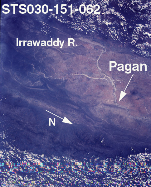
Image Caption: STS030-151-062 Irrawaddy River, Mandalay, Burma May 1989
The generally south flowing Irrawaddy River can be seen in this south-looking view. The Irrawaddy, the major river of Burma (Myanmar) is 1300 miles (2039 km) long. Rising in the mountains of northern Burma, the Irrawaddy River is surrounded on three sides, north, east, and west, by mountains that gives the valley the appearance of a giant horseshoe. The Irrawaddy River Valley, estimated by geologists to be nearly 45 million years old, is home to a majority of Burma's population. The valley is used extensively agricultural. Just to the left of the center of the image, the Chindwin River joins the Irrawaddy at the port city of Myingyan. The Chindwin River rises in the Kumon Range in northern Burma and is the chief tributary of the Irrawaddy. Mandalay is a trade center with railroad and steamer connections, and is located where the Irrawaddy makes a severe course change (lower left quadrant). It is the center for Burmese Buddhism. Clouds cover the mountain ranges to the east (bottom) and west (top) of the broad valley.
The generally south flowing Irrawaddy River can be seen in this south-looking view. The Irrawaddy, the major river of Burma (Myanmar) is 1300 miles (2039 km) long. Rising in the mountains of northern Burma, the Irrawaddy River is surrounded on three sides, north, east, and west, by mountains that gives the valley the appearance of a giant horseshoe. The Irrawaddy River Valley, estimated by geologists to be nearly 45 million years old, is home to a majority of Burma's population. The valley is used extensively agricultural. Just to the left of the center of the image, the Chindwin River joins the Irrawaddy at the port city of Myingyan. The Chindwin River rises in the Kumon Range in northern Burma and is the chief tributary of the Irrawaddy. Mandalay is a trade center with railroad and steamer connections, and is located where the Irrawaddy makes a severe course change (lower left quadrant). It is the center for Burmese Buddhism. Clouds cover the mountain ranges to the east (bottom) and west (top) of the broad valley.
