STS028-98-37

| NASA Photo ID | STS028-98-37 |
| Focal Length | 250mm |
| Date taken | 1989.08.09 |
| Time taken | 22:20:42 GMT |
Resolutions offered for this image:
3899 x 3871 pixels 639 x 635 pixels 5700 x 5900 pixels 500 x 518 pixels 640 x 480 pixels
3899 x 3871 pixels 639 x 635 pixels 5700 x 5900 pixels 500 x 518 pixels 640 x 480 pixels
Cloud masks available for this image:
Spacecraft nadir point: 30.5° N, 96.0° W
Photo center point: 29.5° N, 95.0° W
Photo center point by machine learning:
Photo center point: 29.5° N, 95.0° W
Photo center point by machine learning:
Nadir to Photo Center: Southeast
Spacecraft Altitude: 164 nautical miles (304km)
Country or Geographic Name: | USA-TEXAS |
Features: | HOUSTON, SHIP CHANNEL |
| Features Found Using Machine Learning: | |
Cloud Cover Percentage: | 0 (no clouds present) |
Sun Elevation Angle: | 35° |
Sun Azimuth: | 268° |
Camera: | Hasselblad |
Focal Length: | 250mm |
Camera Tilt: | 27 degrees |
Format: | 5017: Kodak, natural color positive, Ektachrome, X Professional, ASA 64, standard base |
Film Exposure: | Normal |
| Additional Information | |
| Width | Height | Annotated | Cropped | Purpose | Links |
|---|---|---|---|---|---|
| 3899 pixels | 3871 pixels | No | No | Earth From Space collection | Download Image |
| 639 pixels | 635 pixels | No | No | Earth From Space collection | Download Image |
| 5700 pixels | 5900 pixels | No | No | Download Image | |
| 500 pixels | 518 pixels | No | No | Download Image | |
| 640 pixels | 480 pixels | No | No | Download Image |
Download Packaged File
Download a Google Earth KML for this Image
View photo footprint information
Download a GeoTIFF for this photo
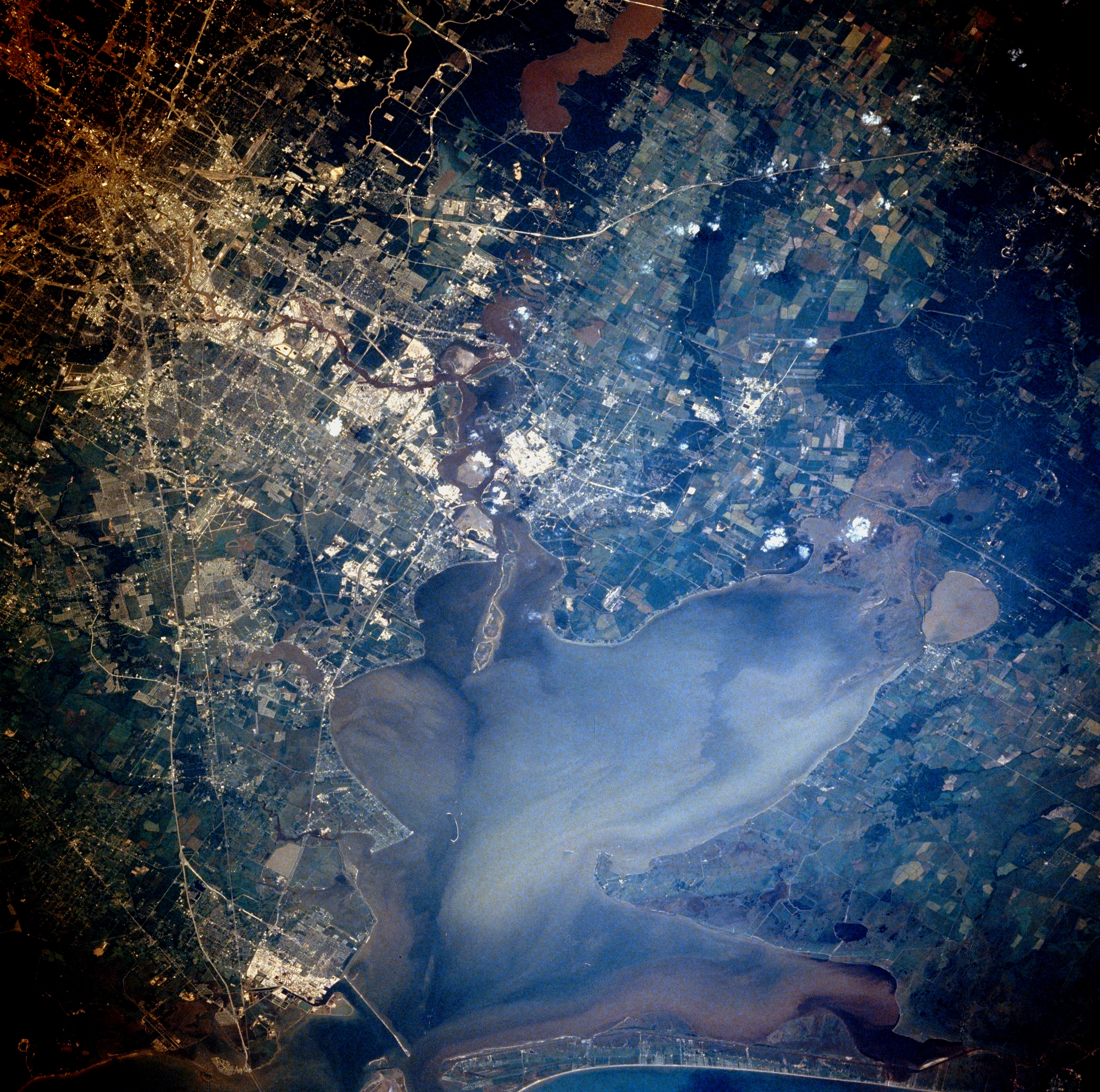
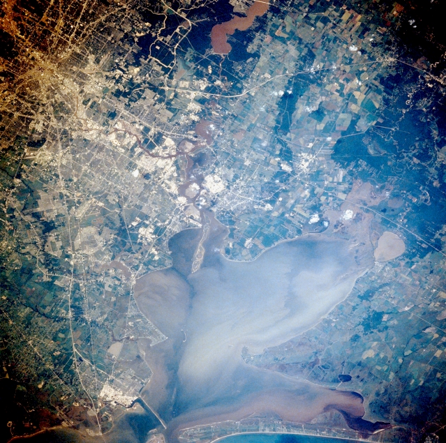
Image Caption: STS028-098-037 Houston and Galveston Bay, Texas, U.S.A. August 1989
Houston, located on the coastal plain of southeast Texas, is known as a leading industrial and manufacturing center and ranks as one of the top three port facilities in the United States. Large industrial processing plants along the east and southeast sides of downtown are shown as highly reflective areas, primarily along the Houston Ship Channel and as far south as Texas City (bottom left corner). Oceangoing ships from the Gulf of Mexico have access to the port of Houston through Galveston Bay, showing a complex pattern of surface currents and turbid plumes, and the Houston Ship Channel, an eastern extension of Buffalo Bayou that winds through downtown Houston. North of the city is muddy Lake Houston, part of the San Jacinto River system that empties into the eastern end of the Houston Ship Channel near the northwest corner of Galveston Bay. The elongated island at this intersection is the result of dumping dredged materials from the Houston Ship Channel. To the east, the Trinity River with its swampy, lake-filled estuary (including oval Lake Anahuac) flows into Trinity Bay, which makes up the northeast segment of Galveston Bay. The extensive sediment patterns in Trinity Bay and Galveston Bay probably resulted from a recent rainstorm.
Houston, located on the coastal plain of southeast Texas, is known as a leading industrial and manufacturing center and ranks as one of the top three port facilities in the United States. Large industrial processing plants along the east and southeast sides of downtown are shown as highly reflective areas, primarily along the Houston Ship Channel and as far south as Texas City (bottom left corner). Oceangoing ships from the Gulf of Mexico have access to the port of Houston through Galveston Bay, showing a complex pattern of surface currents and turbid plumes, and the Houston Ship Channel, an eastern extension of Buffalo Bayou that winds through downtown Houston. North of the city is muddy Lake Houston, part of the San Jacinto River system that empties into the eastern end of the Houston Ship Channel near the northwest corner of Galveston Bay. The elongated island at this intersection is the result of dumping dredged materials from the Houston Ship Channel. To the east, the Trinity River with its swampy, lake-filled estuary (including oval Lake Anahuac) flows into Trinity Bay, which makes up the northeast segment of Galveston Bay. The extensive sediment patterns in Trinity Bay and Galveston Bay probably resulted from a recent rainstorm.
