STS028-97-81
| NASA Photo ID | STS028-97-81 |
| Focal Length | 250mm |
| Date taken | 1989.08.10 |
| Time taken | 20:45:25 GMT |
Resolutions offered for this image:
5302 x 5302 pixels 639 x 639 pixels 5700 x 5900 pixels 500 x 518 pixels 640 x 480 pixels
5302 x 5302 pixels 639 x 639 pixels 5700 x 5900 pixels 500 x 518 pixels 640 x 480 pixels
Cloud masks available for this image:
Spacecraft nadir point: 57.1° N, 143.3° W
Photo center point: 60.0° N, 140.0° W
Photo center point by machine learning:
Photo center point: 60.0° N, 140.0° W
Photo center point by machine learning:
Nadir to Photo Center: Northeast
Spacecraft Altitude: 161 nautical miles (298km)
Country or Geographic Name: | USA-ALASKA |
Features: | MALASPINA GL, YAKUTAT BAY |
| Features Found Using Machine Learning: | |
Cloud Cover Percentage: | 25 (11-25)% |
Sun Elevation Angle: | 47° |
Sun Azimuth: | 161° |
Camera: | Hasselblad |
Focal Length: | 250mm |
Camera Tilt: | Low Oblique |
Format: | 5017: Kodak, natural color positive, Ektachrome, X Professional, ASA 64, standard base |
Film Exposure: | Normal |
| Additional Information | |
| Width | Height | Annotated | Cropped | Purpose | Links |
|---|---|---|---|---|---|
| 5302 pixels | 5302 pixels | No | No | Earth From Space collection | Download Image |
| 639 pixels | 639 pixels | No | No | Earth From Space collection | Download Image |
| 5700 pixels | 5900 pixels | No | No | Download Image | |
| 500 pixels | 518 pixels | No | No | Download Image | |
| 640 pixels | 480 pixels | No | No | Download Image |
Download Packaged File
Download a Google Earth KML for this Image
View photo footprint information
Download a GeoTIFF for this photo
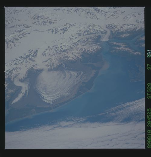
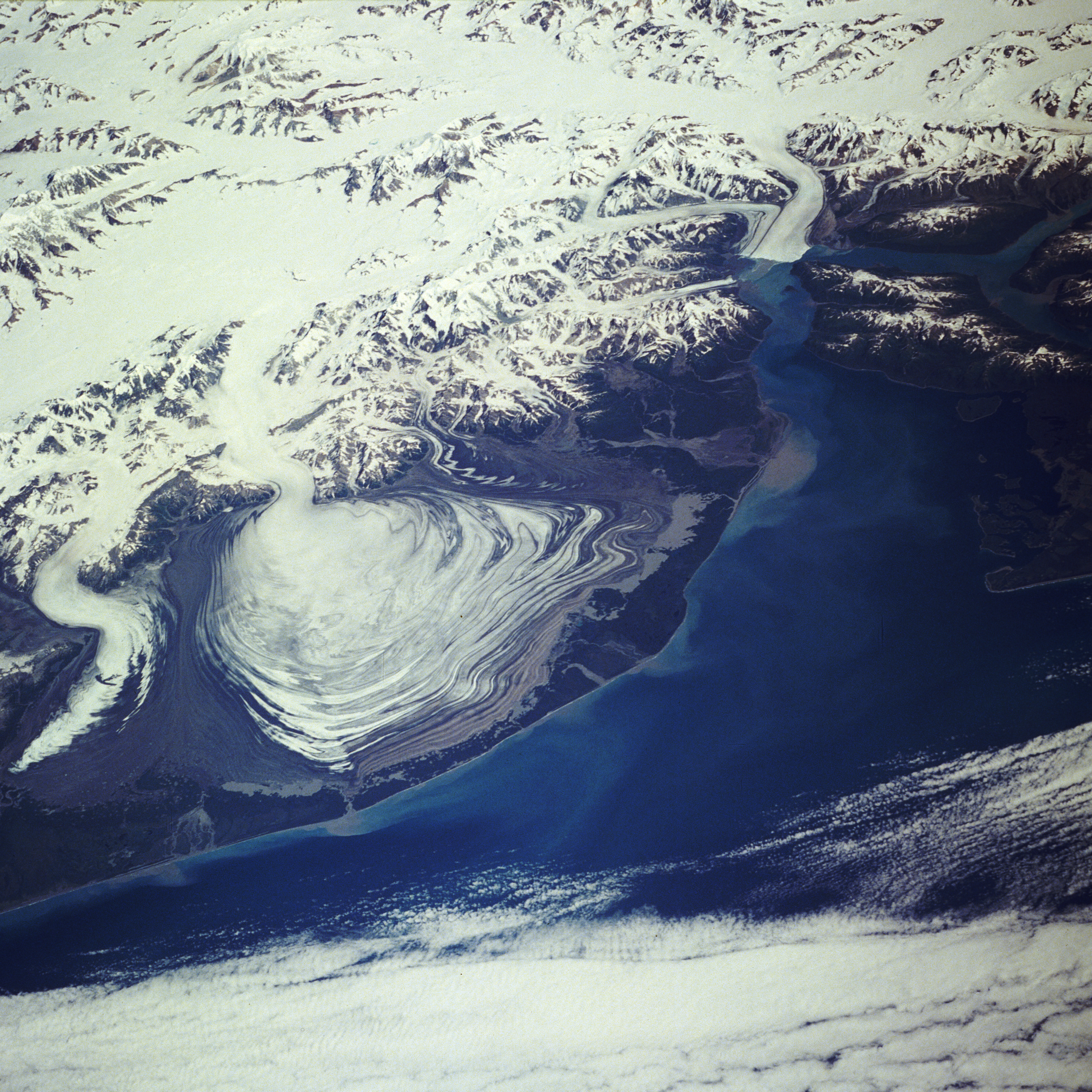
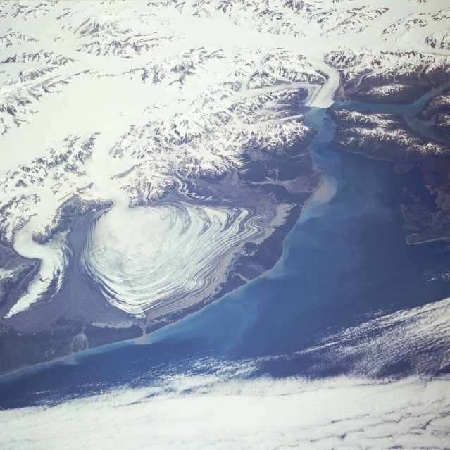
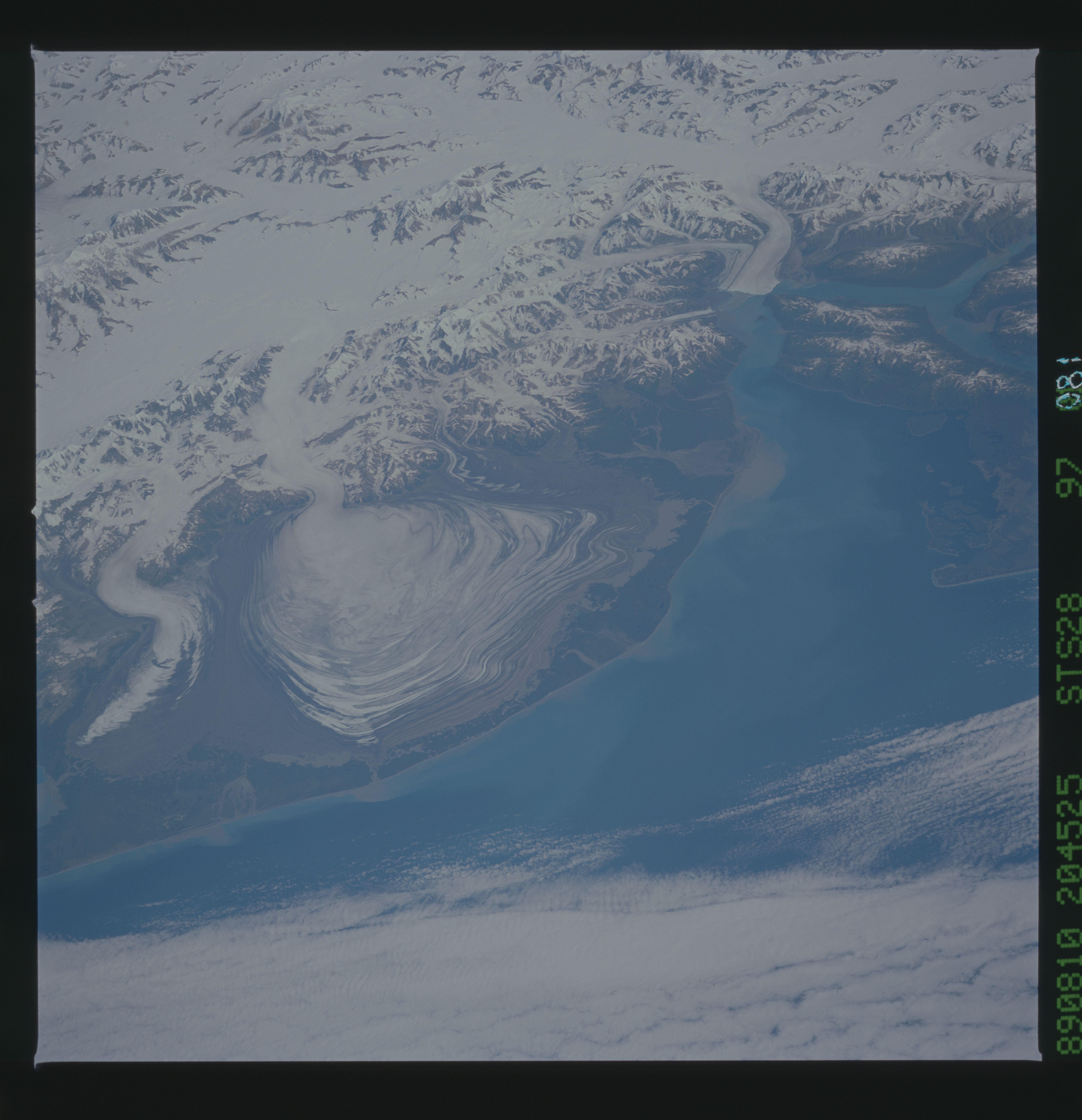
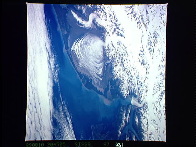
Image Caption: STS028-097-081 Malaspina Glacier, Alaska, U.S.A. August 1989
Malaspina Glacier can be seen just left of the center of this northeast-looking, low-oblique photograph. Located in southern Alaska on the shore of the Gulf of Alaska, Malaspina Glacier is a classic example of a piedmont glacier lying at the foot of a mountain range--in this case, the Saint Elias Mountains (just north of the glacier). The glacier covers an area of 1500 square miles (3900 square kilometers) on the coastal plain, is nearly 60 miles (97 kilometers) long, and is more than 1000 feet (300 meters) thick. The Seward Ice Field is the principal source of ice for the glacier. The glacier moves in surges that push earlier-formed moraines outward into expanding concentric patterns, which you can see along the flanks of the ice mass. To the northwest of Malaspina Glacier is the curved and pointed Agassiz Glacier, which is also fed by the Seward Ice Field. To the northeast of Malaspina Glacier, located at the head of Yakutat Bay, is the Hubbard Glacier, which surged in 1989, blocking the entrance to Russell Fiord and temporarily trapping a large number of marine animals.
Malaspina Glacier can be seen just left of the center of this northeast-looking, low-oblique photograph. Located in southern Alaska on the shore of the Gulf of Alaska, Malaspina Glacier is a classic example of a piedmont glacier lying at the foot of a mountain range--in this case, the Saint Elias Mountains (just north of the glacier). The glacier covers an area of 1500 square miles (3900 square kilometers) on the coastal plain, is nearly 60 miles (97 kilometers) long, and is more than 1000 feet (300 meters) thick. The Seward Ice Field is the principal source of ice for the glacier. The glacier moves in surges that push earlier-formed moraines outward into expanding concentric patterns, which you can see along the flanks of the ice mass. To the northwest of Malaspina Glacier is the curved and pointed Agassiz Glacier, which is also fed by the Seward Ice Field. To the northeast of Malaspina Glacier, located at the head of Yakutat Bay, is the Hubbard Glacier, which surged in 1989, blocking the entrance to Russell Fiord and temporarily trapping a large number of marine animals.
