STS028-84-52

| NASA Photo ID | STS028-84-52 |
| Focal Length | 100mm |
| Date taken | 1989.08.12 |
| Time taken | 19:30:04 GMT |
Resolutions offered for this image:
5700 x 5900 pixels 500 x 518 pixels 640 x 480 pixels 468 x 508 pixels
5700 x 5900 pixels 500 x 518 pixels 640 x 480 pixels 468 x 508 pixels


Cloud masks available for this image:
Spacecraft nadir point: 56.8° N, 145.9° W
Photo center point: 60.0° N, 147.0° W
Photo center point by machine learning:
Photo center point: 60.0° N, 147.0° W
Photo center point by machine learning:
Nadir to Photo Center: North
Spacecraft Altitude: 161 nautical miles (298km)
Country or Geographic Name: | USA-ALASKA |
Features: | CHUGACH MOUNTAINS |
| Features Found Using Machine Learning: | |
Cloud Cover Percentage: | 70 (51-75)% |
Sun Elevation Angle: | 41° |
Sun Azimuth: | 134° |
Camera: | Hasselblad |
Focal Length: | 100mm |
Camera Tilt: | 52 degrees |
Format: | 5017: Kodak, natural color positive, Ektachrome, X Professional, ASA 64, standard base |
Film Exposure: | Normal |
| Additional Information | |
| Width | Height | Annotated | Cropped | Purpose | Links |
|---|---|---|---|---|---|
| 5700 pixels | 5900 pixels | No | No | Download Image | |
| 500 pixels | 518 pixels | No | No | Download Image | |
| 640 pixels | 480 pixels | No | No | Download Image | |
| 468 pixels | 508 pixels | Yes | No | Download Image |
Download Packaged File
Download a Google Earth KML for this Image
View photo footprint information
Download a GeoTIFF for this photo
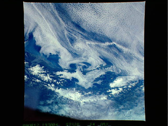
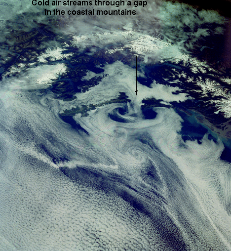
Image Caption: STS028-84-52 Katabatic Winds off Prince William Sound, Alaska
Cold dense air collects on the Columbia Glacier, north of Prince William Sound, then in response to gravity it tumbles down to sea level. This short duration, high intensity wind is known as a Katabatic wind. These type of winds occur at the poles, especially at the more elevated Antarctica. In this photo the wind formed a mushroom-shaped cloud and downwind cloud vortices. On the next orbit (about 90 minutes later), the mushroom shape and cloud vortices were replaced by cloud streaks, common to areas where cold air blows offshore into the boundary layer over the water.
Cold dense air collects on the Columbia Glacier, north of Prince William Sound, then in response to gravity it tumbles down to sea level. This short duration, high intensity wind is known as a Katabatic wind. These type of winds occur at the poles, especially at the more elevated Antarctica. In this photo the wind formed a mushroom-shaped cloud and downwind cloud vortices. On the next orbit (about 90 minutes later), the mushroom shape and cloud vortices were replaced by cloud streaks, common to areas where cold air blows offshore into the boundary layer over the water.
