STS028-82-59
| NASA Photo ID | STS028-82-59 |
| Focal Length | 250mm |
| Date taken | 1989.08.09 |
| Time taken | 20:42:25 GMT |
Resolutions offered for this image:
3874 x 3904 pixels 635 x 639 pixels 5700 x 5900 pixels 500 x 518 pixels 640 x 480 pixels
3874 x 3904 pixels 635 x 639 pixels 5700 x 5900 pixels 500 x 518 pixels 640 x 480 pixels


Cloud masks available for this image:
Spacecraft nadir point: 51.1° N, 101.8° W
Photo center point: 51.5° N, 102.5° W
Photo center point by machine learning:
Photo center point: 51.5° N, 102.5° W
Photo center point by machine learning:
Nadir to Photo Center: Northwest
Spacecraft Altitude: 162 nautical miles (300km)
Country or Geographic Name: | CANADA-S |
Features: | AGRICULTURE, YORKTON |
| Features Found Using Machine Learning: | |
Cloud Cover Percentage: | 5 (1-10)% |
Sun Elevation Angle: | 48° |
Sun Azimuth: | 222° |
Camera: | Hasselblad |
Focal Length: | 250mm |
Camera Tilt: | 17 degrees |
Format: | 5017: Kodak, natural color positive, Ektachrome, X Professional, ASA 64, standard base |
Film Exposure: | Normal |
| Additional Information | |
| Width | Height | Annotated | Cropped | Purpose | Links |
|---|---|---|---|---|---|
| 3874 pixels | 3904 pixels | No | No | Earth From Space collection | Download Image |
| 635 pixels | 639 pixels | No | No | Earth From Space collection | Download Image |
| 5700 pixels | 5900 pixels | No | No | Download Image | |
| 500 pixels | 518 pixels | No | No | Download Image | |
| 640 pixels | 480 pixels | No | No | Download Image |
Download Packaged File
Download a Google Earth KML for this Image
View photo footprint information
Download a GeoTIFF for this photo
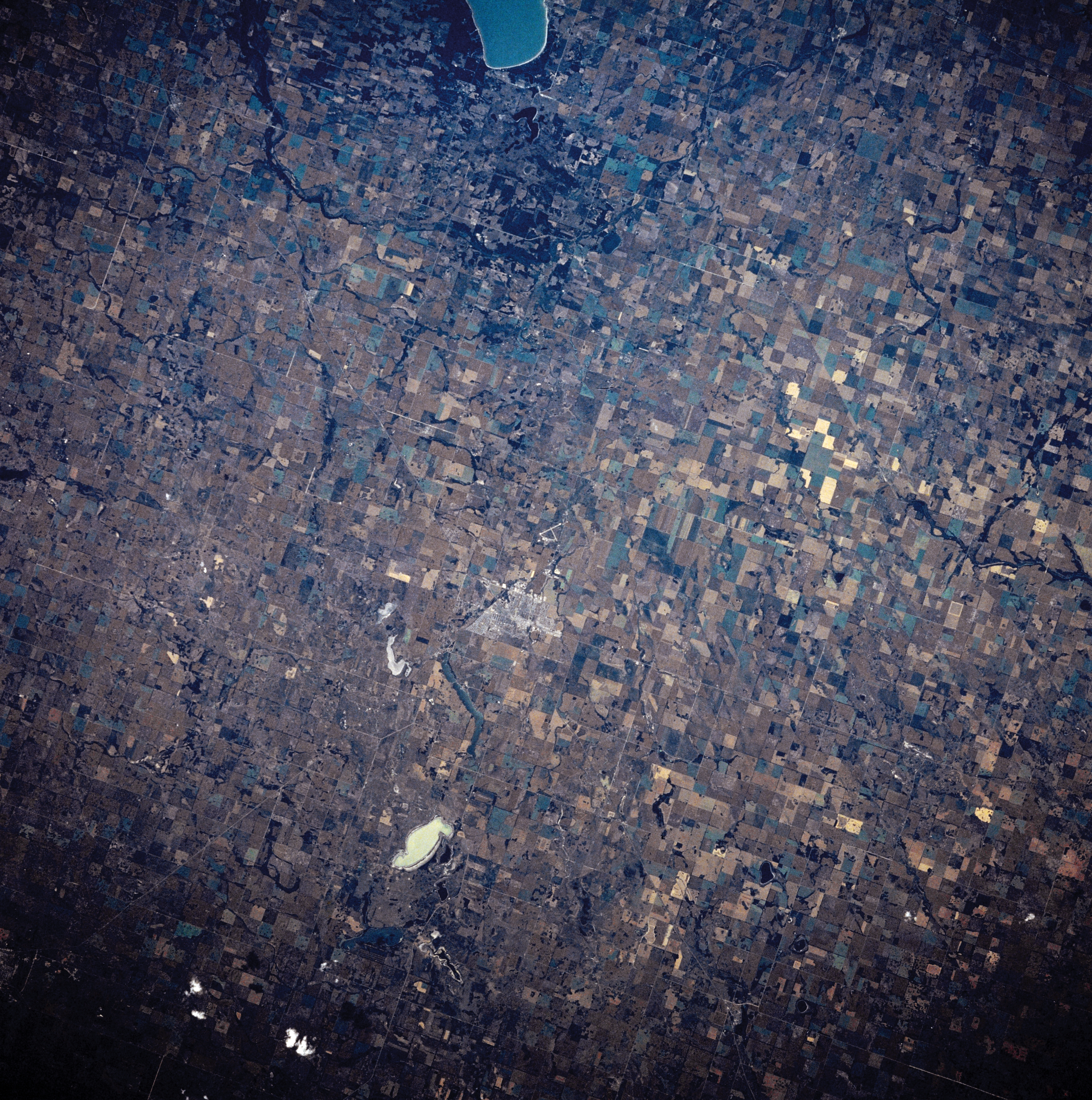
Image Caption: STS028-082-059 Yorkton, Saskatchewan, Canada August 1989
The general terrain in this part of eastern Saskatchewan is a gently rolling to flat plain where large cultivated field patterns are readily observed. Spring wheat is the major field crop that is grown in this northern extension of the Great Plains of North America. The small farming community of Yorkton is the lighter colored area located near the center of the picture. The southern end of Good Spirit Lake can be seen at the top center of the image. The tannish-looking, roughly oval feature towards the bottom center of the image is a dry lake bed. A few small streams can be identified by their tree lined (dark, linear features) channels.
The general terrain in this part of eastern Saskatchewan is a gently rolling to flat plain where large cultivated field patterns are readily observed. Spring wheat is the major field crop that is grown in this northern extension of the Great Plains of North America. The small farming community of Yorkton is the lighter colored area located near the center of the picture. The southern end of Good Spirit Lake can be seen at the top center of the image. The tannish-looking, roughly oval feature towards the bottom center of the image is a dry lake bed. A few small streams can be identified by their tree lined (dark, linear features) channels.
