STS028-82-5
| NASA Photo ID | STS028-82-5 |
| Focal Length | 250mm |
| Date taken | 1989.08.09 |
| Time taken | 15:55:38 GMT |
Resolutions offered for this image:
3904 x 3904 pixels 639 x 639 pixels 5700 x 5900 pixels 500 x 518 pixels 640 x 480 pixels
3904 x 3904 pixels 639 x 639 pixels 5700 x 5900 pixels 500 x 518 pixels 640 x 480 pixels


Cloud masks available for this image:
Spacecraft nadir point: 41.0° N, 121.6° W
Photo center point: 42.5° N, 118.5° W
Photo center point by machine learning:
Photo center point: 42.5° N, 118.5° W
Photo center point by machine learning:
Nadir to Photo Center: East
Spacecraft Altitude: 161 nautical miles (298km)
Country or Geographic Name: | USA-OREGON |
Features: | ALVORD DESERT |
| Features Found Using Machine Learning: | |
Cloud Cover Percentage: | 10 (1-10)% |
Sun Elevation Angle: | 30° |
Sun Azimuth: | 95° |
Camera: | Hasselblad |
Focal Length: | 250mm |
Camera Tilt: | 52 degrees |
Format: | 5017: Kodak, natural color positive, Ektachrome, X Professional, ASA 64, standard base |
Film Exposure: | Normal |
| Additional Information | |
| Width | Height | Annotated | Cropped | Purpose | Links |
|---|---|---|---|---|---|
| 3904 pixels | 3904 pixels | No | No | Earth From Space collection | Download Image |
| 639 pixels | 639 pixels | No | No | Earth From Space collection | Download Image |
| 5700 pixels | 5900 pixels | No | No | Download Image | |
| 500 pixels | 518 pixels | No | No | Download Image | |
| 640 pixels | 480 pixels | No | No | Download Image |
Download Packaged File
Download a Google Earth KML for this Image
View photo footprint information
Download a GeoTIFF for this photo
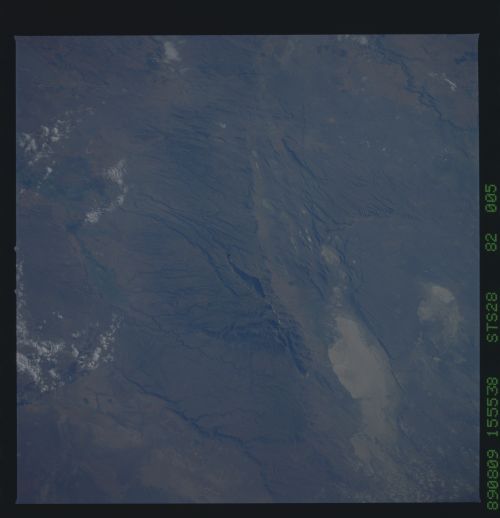
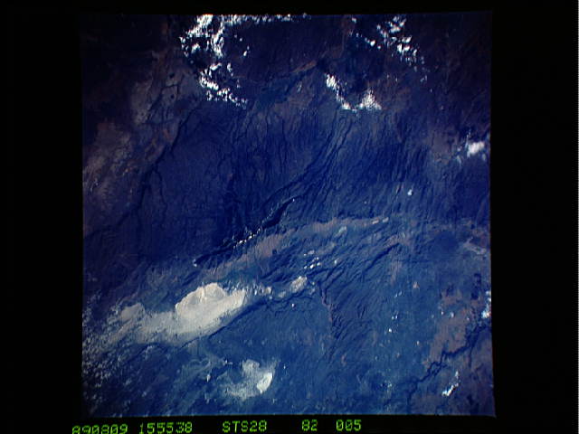
Image Caption: STS028-082-005 Steens Mountains and Alvord Desert, Oregon, U.S.A. August 1989
The rugged fault block of the Steens Mountains, formed nearly 15 million years ago, is visible from the top center to the bottom center of this low-oblique, north-northeast-looking photograph. The western slopes of the mountains rise gradually for approximately 18 miles (29 kilometers) to an elevation of 9354 feet (2851 meters). The eastern face drops more than 5500 feet (1678 meters) in about 3 miles (5 kilometers) to the Alvord Desert, a graben that was created when a portion of the Earth's crust dropped between two faults, creating a valley (the white area in the photograph) rimmed on both sides by cliffs. East of the Alvord Desert are the Sheepshead Mountains. Precipitation is light in the area, except along the upper slopes of the Steens Mountains. Hot, dry summers and cold, dry winters, during which most of the precipitation falls in the form of snow, characterize the climate of the region.
The rugged fault block of the Steens Mountains, formed nearly 15 million years ago, is visible from the top center to the bottom center of this low-oblique, north-northeast-looking photograph. The western slopes of the mountains rise gradually for approximately 18 miles (29 kilometers) to an elevation of 9354 feet (2851 meters). The eastern face drops more than 5500 feet (1678 meters) in about 3 miles (5 kilometers) to the Alvord Desert, a graben that was created when a portion of the Earth's crust dropped between two faults, creating a valley (the white area in the photograph) rimmed on both sides by cliffs. East of the Alvord Desert are the Sheepshead Mountains. Precipitation is light in the area, except along the upper slopes of the Steens Mountains. Hot, dry summers and cold, dry winters, during which most of the precipitation falls in the form of snow, characterize the climate of the region.
