STS002-9-390
| NASA Photo ID | STS002-9-390 |
| Focal Length | 100mm |
| Date taken | 1981.11.__ |
| Time taken | GMT |


Cloud masks available for this image:
Spacecraft nadir point:
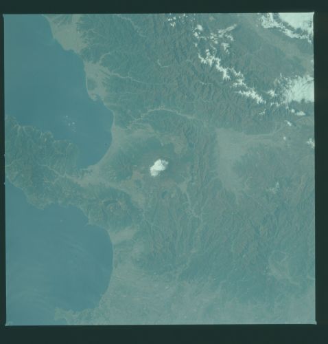
Photo center point: 35.5° N, 139.0° E
Photo center point by machine learning:
Photo center point: 35.5° N, 139.0° E
Photo center point by machine learning:
Nadir to Photo Center:
Spacecraft Altitude: nautical miles (0km)
Country or Geographic Name: | JAPAN |
Features: | MT. FUJI, SURUGA BAY |
| Features Found Using Machine Learning: | |
Cloud Cover Percentage: | 5 (1-10)% |
Sun Elevation Angle: | ° |
Sun Azimuth: | ° |
Camera: | Hasselblad |
Focal Length: | 100mm |
Camera Tilt: | Near Vertical |
Format: | QX824: Kodak Ektachrome 64 |
Film Exposure: | Normal |
| Additional Information | |
| Width | Height | Annotated | Cropped | Purpose | Links |
|---|---|---|---|---|---|
| 4393 pixels | 4600 pixels | No | No | Download Image | |
| 478 pixels | 500 pixels | No | No | Download Image | |
| 640 pixels | 480 pixels | No | No | Download Image |
Download Packaged File
Download a Google Earth KML for this Image
View photo footprint information
Download a GeoTIFF for this photo
Image Caption: Mt. Fuji, (35.5N, 139.0E) the revered extinct volcano, on the main island of Honshu, Japan dominates the center of this photo. The summit of this 12,400 foot extinct volcano remains snow-covered throughout the year and can be seen from many miles in all directions. The Isu Peninsula just to the south, bisects the coast to form Sagami Bay to the north and Suruga Bay to the south. Part of Tokyo can be seen on the right edge of the photograph.
