SL3-122-2517

| NASA Photo ID | SL3-122-2517 |
| Focal Length | 100mm |
| Date taken | 1973.__.__ |
| Time taken | GMT |
Resolutions offered for this image:
5122 x 5122 pixels 640 x 640 pixels 4400 x 4600 pixels 4400 x 4600 pixels 478 x 500 pixels
5122 x 5122 pixels 640 x 640 pixels 4400 x 4600 pixels 4400 x 4600 pixels 478 x 500 pixels


Cloud masks available for this image:
Spacecraft nadir point:
Photo center point: 48.5° N, 113.0° W
Photo center point by machine learning:
Photo center point: 48.5° N, 113.0° W
Photo center point by machine learning:
Nadir to Photo Center:
Spacecraft Altitude: nautical miles (0km)
Country or Geographic Name: | USA-MONTANA |
Features: | FLATHEAD L., ROCKY MTNS |
| Features Found Using Machine Learning: | |
Cloud Cover Percentage: | 15 (11-25)% |
Sun Elevation Angle: | ° |
Sun Azimuth: | ° |
Camera: | Hasselblad |
Focal Length: | 100mm |
Camera Tilt: | Low Oblique |
Format: | SO368: Kodak Ektachrome MS, equivalent to 2448 Kodak Aerochrome, ASA64, thin base, fine grain |
Film Exposure: | Normal |
| Additional Information | |
| Width | Height | Annotated | Cropped | Purpose | Links |
|---|---|---|---|---|---|
| 5122 pixels | 5122 pixels | No | No | Earth From Space collection | Download Image |
| 640 pixels | 640 pixels | No | No | Earth From Space collection | Download Image |
| 4400 pixels | 4600 pixels | No | No | Download Image | |
| 4400 pixels | 4600 pixels | No | No | Original file from film scan | Download Image |
| 478 pixels | 500 pixels | No | No | Download Image |
Download Packaged File
Download a Google Earth KML for this Image
View photo footprint information
Download a GeoTIFF for this photo
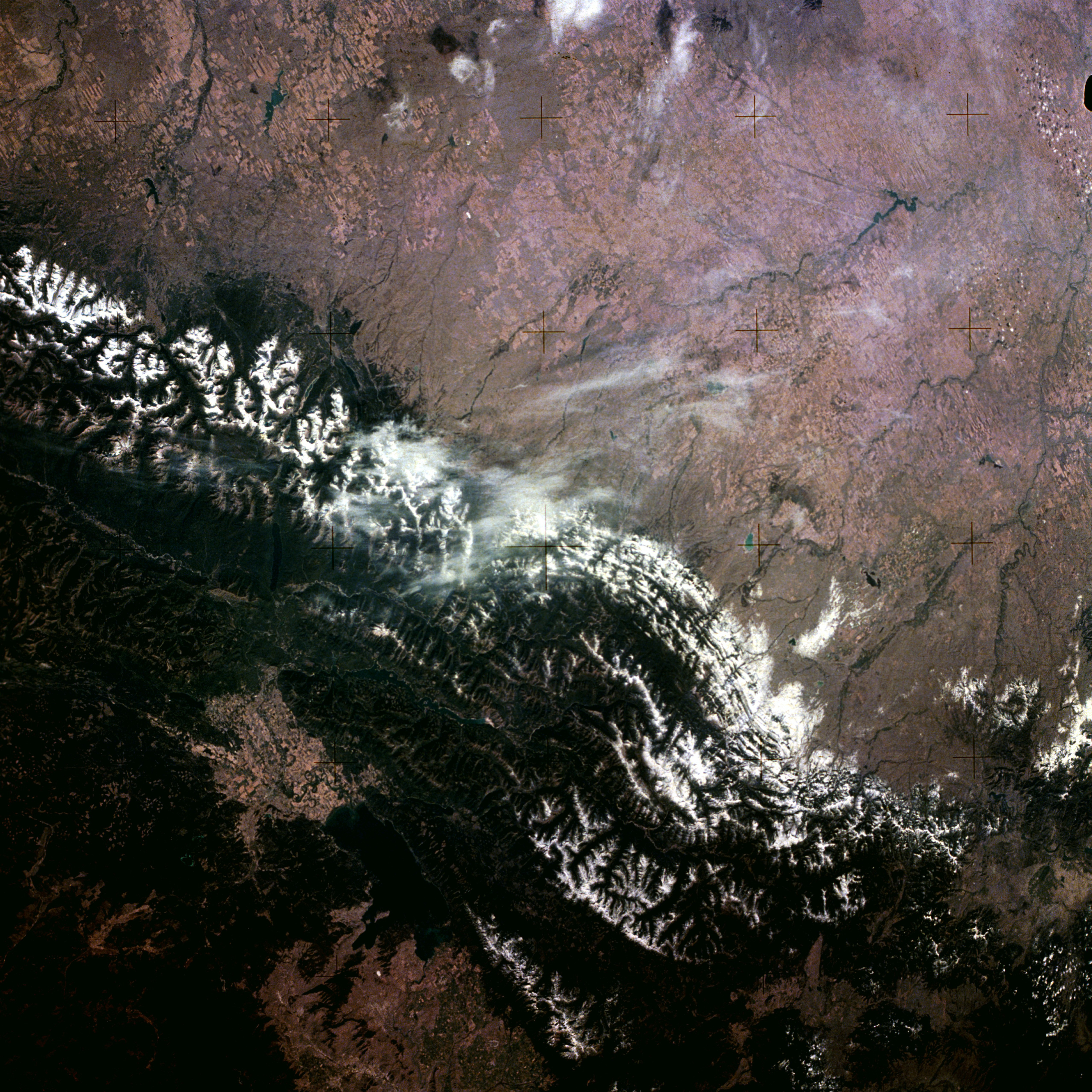
Image Caption: SL3-122-2517 Rocky Mountains and Flathead Lake, Montana, U.S.A. 1973
The snow-covered Lewis Range of the northern Rocky Mountains and the western portion of the northern Great Plains can be seen in this northeast-looking, low-oblique photograph. Uplifted nearly 60 million years ago, the Lewis Range is the result of an overthrust fault in which older, more resistant rock overlaid younger, less resistant, sedimentary rock. Within the Lewis Range is Glacier National Park, an area comprising 1 013 100 acres (410 306 hectares) and containing more than 50 glaciers, more than 200 glacier-fed lakes, mountain peaks exceeding 10 000 feet (3050 meters), large forests, waterfalls, abundant wildlife, and numerous varieties of wild flowers. The park straddles the Continental Divide, where rivers east of the divide flow into the Atlantic Ocean or the Gulf of Mexico and rivers west of the divide flow into the Pacific Ocean. To the east of the Lewis Range is seen an extensive grassland of the northern Great Plains. West of the Lewis Range are the dark blue waters of Flathead Lake. The lake sits at the southern end of Rocky Mountain Trench, a long faulted valley that extends northward into northern Canada. Flathead Lake, a popular recreational area more than 30 miles (48 kilometers) long and 12 to 14 miles (19 to 23 kilometers) wide, has an irregular shoreline and many small islands. The small city of Kalispell (barely discernible on the photograph) is located at the northern end of Flathead Lake and just west of Glacier National Park. The city is a tourist and trade center in a rich agricultural, fruit, and timber region.
The snow-covered Lewis Range of the northern Rocky Mountains and the western portion of the northern Great Plains can be seen in this northeast-looking, low-oblique photograph. Uplifted nearly 60 million years ago, the Lewis Range is the result of an overthrust fault in which older, more resistant rock overlaid younger, less resistant, sedimentary rock. Within the Lewis Range is Glacier National Park, an area comprising 1 013 100 acres (410 306 hectares) and containing more than 50 glaciers, more than 200 glacier-fed lakes, mountain peaks exceeding 10 000 feet (3050 meters), large forests, waterfalls, abundant wildlife, and numerous varieties of wild flowers. The park straddles the Continental Divide, where rivers east of the divide flow into the Atlantic Ocean or the Gulf of Mexico and rivers west of the divide flow into the Pacific Ocean. To the east of the Lewis Range is seen an extensive grassland of the northern Great Plains. West of the Lewis Range are the dark blue waters of Flathead Lake. The lake sits at the southern end of Rocky Mountain Trench, a long faulted valley that extends northward into northern Canada. Flathead Lake, a popular recreational area more than 30 miles (48 kilometers) long and 12 to 14 miles (19 to 23 kilometers) wide, has an irregular shoreline and many small islands. The small city of Kalispell (barely discernible on the photograph) is located at the northern end of Flathead Lake and just west of Glacier National Park. The city is a tourist and trade center in a rich agricultural, fruit, and timber region.
