NASA6-712-31
| NASA Photo ID | NASA6-712-31 |
| Focal Length | 100mm |
| Date taken | 1998.01.05 |
| Time taken | GMT |
Resolutions offered for this image:
4096 x 4096 pixels 640 x 640 pixels 5700 x 6000 pixels 500 x 526 pixels
4096 x 4096 pixels 640 x 640 pixels 5700 x 6000 pixels 500 x 526 pixels


Cloud masks available for this image:
Spacecraft nadir point:
Photo center point: 11.0° N, 71.5° W
Photo center point by machine learning:
Photo center point: 11.0° N, 71.5° W
Photo center point by machine learning:
Nadir to Photo Center:
Spacecraft Altitude: nautical miles (0km)
Country or Geographic Name: | VENEZUELA |
Features: | TABLAZO BAY |
| Features Found Using Machine Learning: | |
Cloud Cover Percentage: | 0 (no clouds present) |
Sun Elevation Angle: | ° |
Sun Azimuth: | ° |
Camera: | Hasselblad |
Focal Length: | 100mm |
Camera Tilt: | Low Oblique |
Format: | 5069: Kodak Elite 100S, E6 Reversal, Replaces Lumiere, Warmer in tone vs. Lumiere |
Film Exposure: | Normal |
| Additional Information | |
| Width | Height | Annotated | Cropped | Purpose | Links |
|---|---|---|---|---|---|
| 4096 pixels | 4096 pixels | No | No | Earth From Space collection | Download Image |
| 640 pixels | 640 pixels | No | No | Earth From Space collection | Download Image |
| 5700 pixels | 6000 pixels | No | No | Download Image | |
| 500 pixels | 526 pixels | No | No | Download Image |
Download Packaged File
Download a Google Earth KML for this Image
View photo footprint information
Download a GeoTIFF for this photo
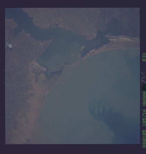
Image Caption: NASA6-712-031 Tablazo Bay, Gulf of Venezuela, Venezuela Fall 1997
The Gulf of Venezuela with a heavy load of sediment occupies most of the left portion of this near-vertical-looking view. An inlet of the Caribbean Sea, the Gulf is a major shipping lane for Venezuelan oil. The oil is shipped from ports in Maracaibo (upper right) and the new city of Tablazo across the Bay of Tablazo from Maracaibo. The bay is constantly dredged to allow the passage of large oil tankers to and from the ports of Maracaibo and Tablazo and other ports in the northeastern part of Lake Maracaibo (not visible on image). This whole region is considered the oil capital of South America.
The Gulf of Venezuela with a heavy load of sediment occupies most of the left portion of this near-vertical-looking view. An inlet of the Caribbean Sea, the Gulf is a major shipping lane for Venezuelan oil. The oil is shipped from ports in Maracaibo (upper right) and the new city of Tablazo across the Bay of Tablazo from Maracaibo. The bay is constantly dredged to allow the passage of large oil tankers to and from the ports of Maracaibo and Tablazo and other ports in the northeastern part of Lake Maracaibo (not visible on image). This whole region is considered the oil capital of South America.
