ISS067-E-15588
| NASA Photo ID | ISS067-E-15588 |
| Focal Length | 1150mm |
| Date taken | 2022.04.17 |
| Time taken | 11:03:16 GMT |
5568 x 3712 pixels 720 x 480 pixels 720 x 480 pixels 5568 x 3712 pixels 640 x 427 pixels


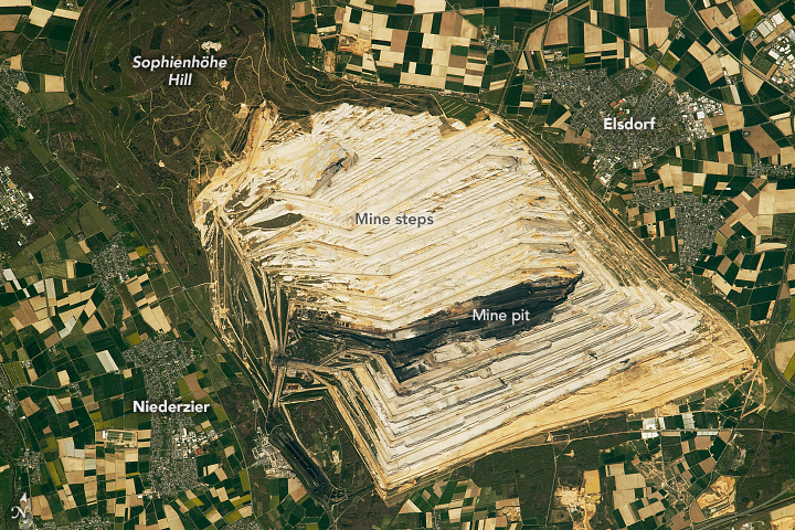


Photo center point: 50.9° N, 6.5° E
Photo center point by machine learning: 50.91° N, 6.52° E

Country or Geographic Name: | GERMANY |
Features: | HAMBACH SURFACE MINE, ELSDORF, NIEDERZIER |
| Features Found Using Machine Learning: | |
Cloud Cover Percentage: | 10 (1-10)% |
Sun Elevation Angle: | 49° |
Sun Azimuth: | 170° |
Camera: | Nikon D5 Electronic Still Camera |
Focal Length: | 1150mm |
Camera Tilt: | 16 degrees |
Format: | 5568E: 5568 x 3712 pixel CMOS sensor, 35.9 x 23.9 mm, total pixels: 21.33 million, Nikon FX format |
Film Exposure: | |
| Additional Information | |
| Width | Height | Annotated | Cropped | Purpose | Links |
|---|---|---|---|---|---|
| 5568 pixels | 3712 pixels | No | No | NASA's Earth Observatory web site | Download Image |
| 720 pixels | 480 pixels | Yes | No | NASA's Earth Observatory web site | Download Image |
| 720 pixels | 480 pixels | Yes | No | NASA's Earth Observatory web site | Download Image |
| 5568 pixels | 3712 pixels | No | No | Download Image | |
| 640 pixels | 427 pixels | No | No | Download Image |
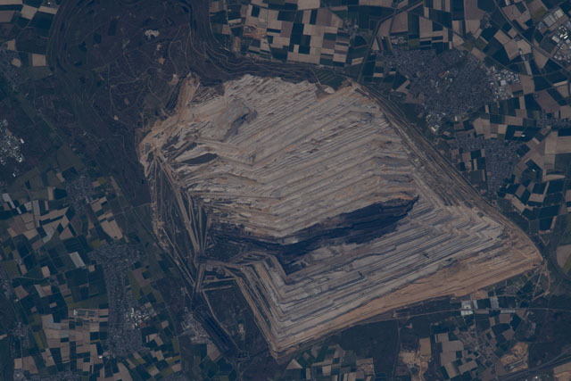
An astronaut onboard the International Space Station (ISS) took this photograph of Hambach Surface Mine in North Rhine-Westphalia, Germany. The open-pit coal mining area spans nearly 44 square kilometers (17 square miles) and drops to depths almost 300 meters (1,000 feet) below sea level. The villages of Elsdorf and Niederzier sit next to the mine, and numerous agricultural fields appear as angular shapes on the surrounding landscape.
As the largest open-pit coal mine in Germany, Hambach produces 40 million tons of lignite annually. Also known as brown coal, lignite is a soft sedimentary rock produced from peat, an organic material formed from decayed plants. Typically used to generate electricity, brown coal is considered the lowest grade of coal because of its high moisture content and low heating value.
The tan-hued lines etching towards the center of the Hambach mine are large steps, a safety measure typical of open-pit operations. Composed of a slanted wall and a horizontal floor portion called the "bench", the steps help prevent rocks and boulders from falling into the pit.
Mine spoils--material removed to access the lignite--are deposited on the mine's excavated sides as an effort to eventually rehabilitate some of the landscape. Sophienhohe Hill, one of the area's landmarks, was built from mine spoils and has become a popular recreational area. When mining operations are complete, plans call for the remaining Hambach hollow to be recultivated as a lake, with groundwater and water from the River Rhine pipeline being used to fill the pit.
