ISS064-E-9397

| NASA Photo ID | ISS064-E-9397 |
| Focal Length | 78mm |
| Date taken | 2020.12.03 |
| Time taken | 20:59:19 GMT |
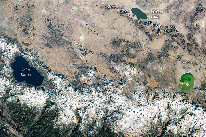
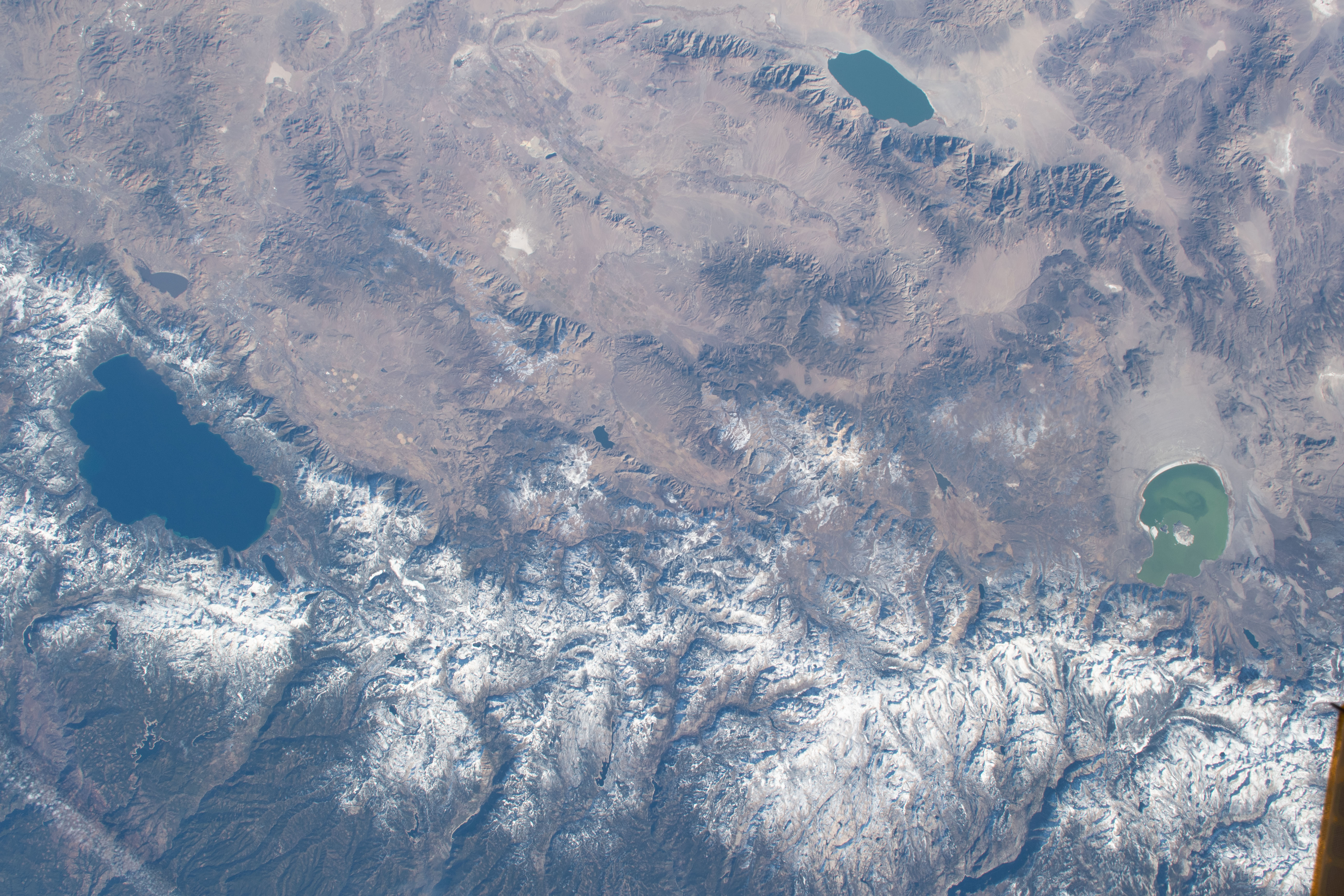
Photo center point: 38.5° N, 119.5° W
Photo center point by machine learning:
Country or Geographic Name: | USA-NEVADA |
Features: | LAKE TAHOE, CALIFORNIA, MONO LAKE, WALKER LAKE, SIERRA NEVADA MOUNTAINS, SNOW |
| Features Found Using Machine Learning: | |
Cloud Cover Percentage: | 10 (1-10)% |
Sun Elevation Angle: | 28° |
Sun Azimuth: | 197° |
Camera: | Nikon D5 Electronic Still Camera |
Focal Length: | 78mm |
Camera Tilt: | 20 degrees |
Format: | 5568E: 5568 x 3712 pixel CMOS sensor, 35.9 x 23.9 mm, total pixels: 21.33 million, Nikon FX format |
Film Exposure: | |
| Additional Information | |
| Width | Height | Annotated | Cropped | Purpose | Links |
|---|---|---|---|---|---|
| 720 pixels | 480 pixels | Yes | Yes | Download Image | |
| 5568 pixels | 3712 pixels | No | No | Download Image | |
| 640 pixels | 427 pixels | No | No | Download Image |
While passing over California's Central Valley, an astronaut onboard the International Space Station looked east and shot this photograph of Lake Tahoe, Walker Lake, and Mono Lake. December snow cover accents the climatic transition between the colder, higher elevations of the Sierra Nevada and the warmer, lower valleys of the adjacent Great Basin desert.
Lake Tahoe, the largest alpine lake in North America, straddles the state line between California and Nevada. Tahoe is 501 meters (1,645 feet) deep, making it the second deepest lake in the United States (after Crater Lake in Oregon). This area, while popular year-round, is a major tourist attraction during the winter because the surrounding mountains make for great skiing and snow sports.
Located on the eastern side of the Sierra Nevada. Mono Lake is an endorheic basin; it has no outflow, so evaporation is the only natural way water leaves the system. Farther into the Great Basin lies Walker Lake. Fed by the Walker River to the north and by groundwater flow, Walker Lake also has no natural outlet. With no outflow, the lakes are rich in dissolved salts, which leads to high pH and high salinity that can fluctuate depending on their respective water inflows. Some of the historical water levels of Mono Lake are marked by lighter “bathtub rings” around the shoreline that indicate where the lake surface once stood. Past shorelines are similarly visible around Walker Lake.
Perhaps most interesting about this photo is that all three lakes are different colors. This can be partially attributed to varying water depths, but Mono Lake is unique. Because of high salinity levels and a dearth of fish, brine shrimp call this lake home while feasting on algae. When the populations of shrimp are low, the algae can thrive and turn the lake green.
