ISS064-E-6310
| NASA Photo ID | ISS064-E-6310 |
| Focal Length | 400mm |
| Date taken | 2020.11.26 |
| Time taken | 12:26:03 GMT |
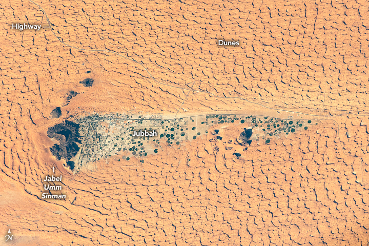


Photo center point: 28.0° N, 41.1° E
Photo center point by machine learning: 28.02° N, 41.07° E

Country or Geographic Name: | SAUDI ARABIA |
Features: | JUBBAH, SAND DUNES, AN NAFUD DESERT, AGRICULTURE |
| Features Found Using Machine Learning: | |
Cloud Cover Percentage: | 10 (1-10)% |
Sun Elevation Angle: | 20° |
Sun Azimuth: | 229° |
Camera: | Nikon D5 Electronic Still Camera |
Focal Length: | 400mm |
Camera Tilt: | 33 degrees |
Format: | 5568E: 5568 x 3712 pixel CMOS sensor, 35.9 x 23.9 mm, total pixels: 21.33 million, Nikon FX format |
Film Exposure: | |
| Additional Information | |
| Width | Height | Annotated | Cropped | Purpose | Links |
|---|---|---|---|---|---|
| 720 pixels | 480 pixels | Yes | Yes | Download Image | |
| 5568 pixels | 3712 pixels | No | No | Download Image | |
| 640 pixels | 427 pixels | No | No | Download Image |
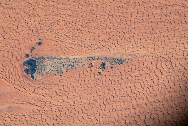
Long-sustained westerly winds shaped the dunes surrounding the Saudi Arabian oasis of Jubbah in this photograph shot by an astronaut from the International Space Station (ISS). Jubbah sits in the protective wind shadow of Jabel Umm Sinman, which roughly translates from Arabic as "two camel-hump mountain"(//saudi-archaeology.com/sites/jubbah). The hard, black rock of the mountain disrupts wind flow and blocks dunes from forming on its lee side. The area around Jabel Umm Sinman has been at the center of significant climatic and anthropological shifts during the Holocene, a geologic term for the past 10,000 years.
Jubbah is built in the basin of a paleolake in the middle of the Nefud Desert, about 650 kilometers (400 miles) northwest of Riyadh. A paleolake is an area where a lake previously existed, but no longer holds any water due to a change in climate. Today the ancient lakebed rests hundreds of feet below the neighboring dunes.
Prior to the desertification of the Arabian Peninsula, Jubbah Lake was one of a network of freshwater sources in what was then a more humid environment. Even as the region became more arid, Jubbah Lake likely continued to hold freshwater for some time due to its position amid the groundwater-recharging dunes. This continuous, extended period of freshwater made Jubbah a destination for early humans and animals in the Nefud Desert.
Among the dunes to the north of the city, a highway extends north-south through the desert, following a path historically taken by caravan traders. The highway and the modern agriculture - evident in the telltale circular fields of center-pivot irrigation - are just the latest iteration of human activity in the area. The mountain also contains petroglyphs that record the lifestyle and culture of early inhabitants. The petroglyphs, declared a UNESCO World Heritage Site, have been instrumental for archeologists and historians seeking to understand occupation and settlement patterns in the region.
