ISS064-E-16203
| NASA Photo ID | ISS064-E-16203 |
| Focal Length | 400mm |
| Date taken | 2020.12.24 |
| Time taken | 19:12:50 GMT |
150 x 100 pixels 720 x 600 pixels 720 x 480 pixels 5568 x 3712 pixels 640 x 427 pixels

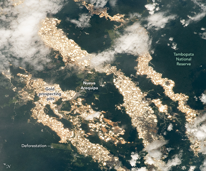
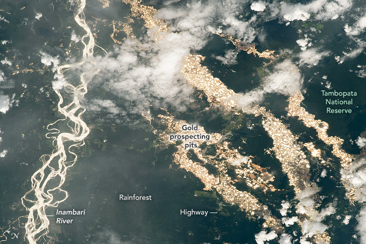


Photo center point: 12.9° S, 70.0° W
Photo center point by machine learning: 12.88° S, 70.05° W

Country or Geographic Name: | PERU |
Features: | SUNGLINT, MINE, INAMBARI RIVER |
| Features Found Using Machine Learning: | |
Cloud Cover Percentage: | 50 (26-50)% |
Sun Elevation Angle: | 49° |
Sun Azimuth: | 248° |
Camera: | Nikon D5 Electronic Still Camera |
Focal Length: | 400mm |
Camera Tilt: | 39 degrees |
Format: | 5568E: 5568 x 3712 pixel CMOS sensor, 35.9 x 23.9 mm, total pixels: 21.33 million, Nikon FX format |
Film Exposure: | |
| Additional Information | |
| Width | Height | Annotated | Cropped | Purpose | Links |
|---|---|---|---|---|---|
| 150 pixels | 100 pixels | Yes | Yes | Download Image | |
| 720 pixels | 600 pixels | Yes | Yes | NASA's Earth Observatory web site | Download Image |
| 720 pixels | 480 pixels | Yes | Yes | Download Image | |
| 5568 pixels | 3712 pixels | No | No | Download Image | |
| 640 pixels | 427 pixels | No | No | Download Image |
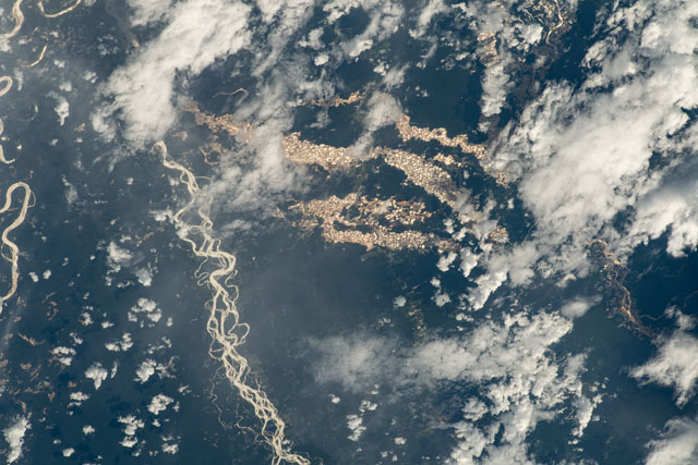
An astronaut aboard the International Space Station (ISS) took this photograph of numerous gold prospecting pits in eastern Peru. The pits - usually hidden from an astronaut's view by cloud cover or outside the Sun's glint point - stand out brilliantly in this image due to the reflected sunlight. The multiple meandering channels of the Inambari River are visible on the left side of the image. The river and the pits cut through the otherwise unbroken Amazon rainforest in Peru's Madre de Dios state.
In this very wet climate, the prospecting pits appear as hundreds of tightly packed water-filled basins. Likely dug by garimperos (independent miners), each pit is surrounded by de-vegetated areas of muddy spoil. These deforested tracts follow the courses of ancient rivers that deposited sediments, including gold. For scale, the western tract at image center is 15 kilometers (10 miles) long.
Peru is the sixth largest producer of gold in the world, and Madre de Dios is home to one of the largest independent gold mining industries in the world. Mining is the main cause of deforestation in the region, and it also can cause mercury pollution from the gold-extraction process. Yet tens of thousands of people earn their living from this unregistered mining.
The small town of Nueva Arequipa is just visible along the Southern Interoceanic Highway. Inaugurated in 2011, the highway, is the only road connection between Brazil and Peru. It was intended to stimulate trade and tourism, but due to the great expansion of surface prospecting, deforestation may be the larger result of the highway. Some areas in the state are protected from mining, such as the Tambopata National Reserve.
