ISS064-E-15994

| NASA Photo ID | ISS064-E-15994 |
| Focal Length | 24mm |
| Date taken | 2020.12.25 |
| Time taken | 18:11:48 GMT |
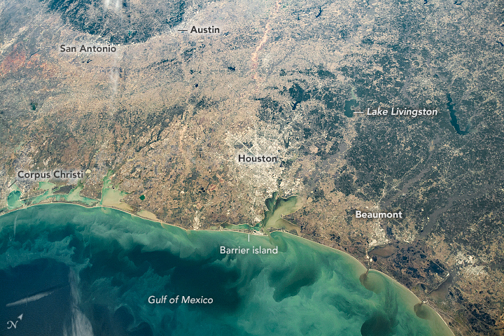


Photo center point: 29.5° N, 95.5° W
Photo center point by machine learning:
Country or Geographic Name: | USA-TEXAS |
Features: | GULF OF MEXICO, HOUSTON, SEDIMENT, BRAZOS RIVER, TRINITY BAY, GALVESTON BAY |
| Features Found Using Machine Learning: | |
Cloud Cover Percentage: | 10 (1-10)% |
Sun Elevation Angle: | 36° |
Sun Azimuth: | 178° |
Camera: | Nikon D5 Electronic Still Camera |
Focal Length: | 24mm |
Camera Tilt: | 19 degrees |
Format: | 5568E: 5568 x 3712 pixel CMOS sensor, 35.9 x 23.9 mm, total pixels: 21.33 million, Nikon FX format |
Film Exposure: | |
| Additional Information | |
| Width | Height | Annotated | Cropped | Purpose | Links |
|---|---|---|---|---|---|
| 720 pixels | 480 pixels | Yes | No | Download Image | |
| 5568 pixels | 3712 pixels | No | No | Download Image | |
| 640 pixels | 427 pixels | No | No | Download Image |
An astronaut onboard the International Space Station (ISS) took this photo of the Texas Gulf Coast. The field of view is about the same as what astronauts see with their unaided eyes from station windows. The photo centers on Houston, home to NASA Johnson Space Center, where astronauts live and train. They get part of their education from the Earth Science and Remote Sensing Unit, which works with them to achieve the diverse science objectives of astronaut photography of Earth.
Lining the Texas coast are long, narrow barrier islands that create protective bays between the Gulf of Mexico and the mainland. The Gulf Coast region is a center for offshore oil and gas drilling and associated infrastructure. Channels between the barrier islands allow ships to bring crude petroleum products to ports and refineries along the bays—especially Corpus Christi, Houston, and Beaumont.
East of Houston, pine forests and swamps dominate the coastal landscape. Several artificial reservoirs have been constructed to impound rivers flowing toward the coast. The greater Houston area depends on nearby reservoirs such as Lake Livingston for its water supply. Although groundwater exists in aquifers beneath Houston, limits on groundwater extraction have been put in place to reduce land subsidence in the region.
West and northwest of Houston, the cities of San Antonio and Austin border a central Texas geographic region called the Edwards Plateau. The region marks changes in topography, geology, ecology, and climate from flat and humid coastal wetlands to rocky hills with woodlands (dark green in the image). The area is known regionally as the Texas Hill Country.
