ISS063-E-19838

| NASA Photo ID | ISS063-E-19838 |
| Focal Length | 500mm |
| Date taken | 2020.05.28 |
| Time taken | 08:30:38 GMT |
3712 x 5568 pixels 720 x 900 pixels 720 x 900 pixels 5568 x 3712 pixels 640 x 427 pixels
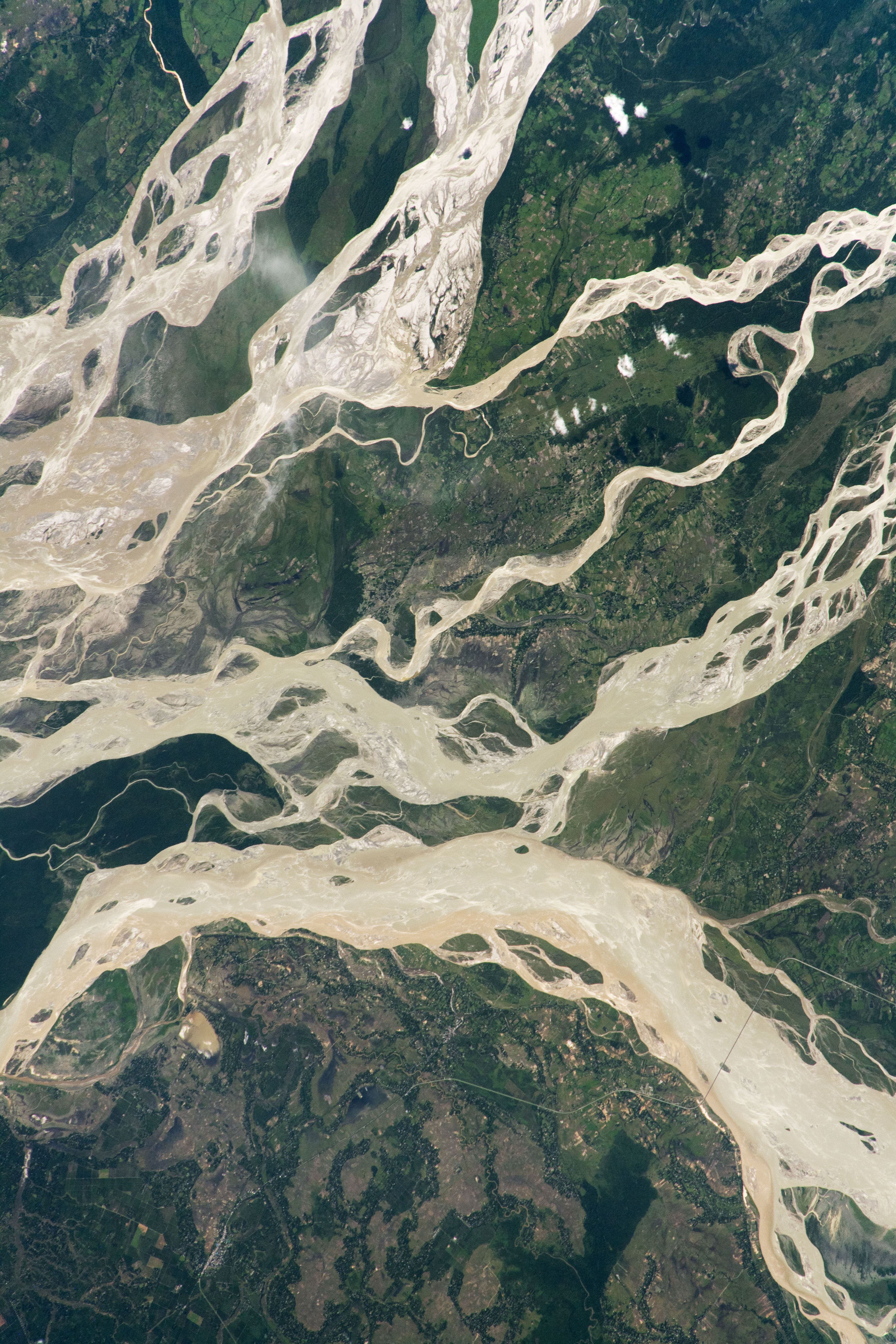
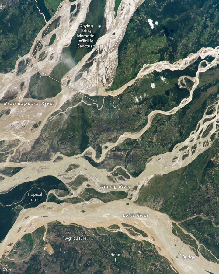

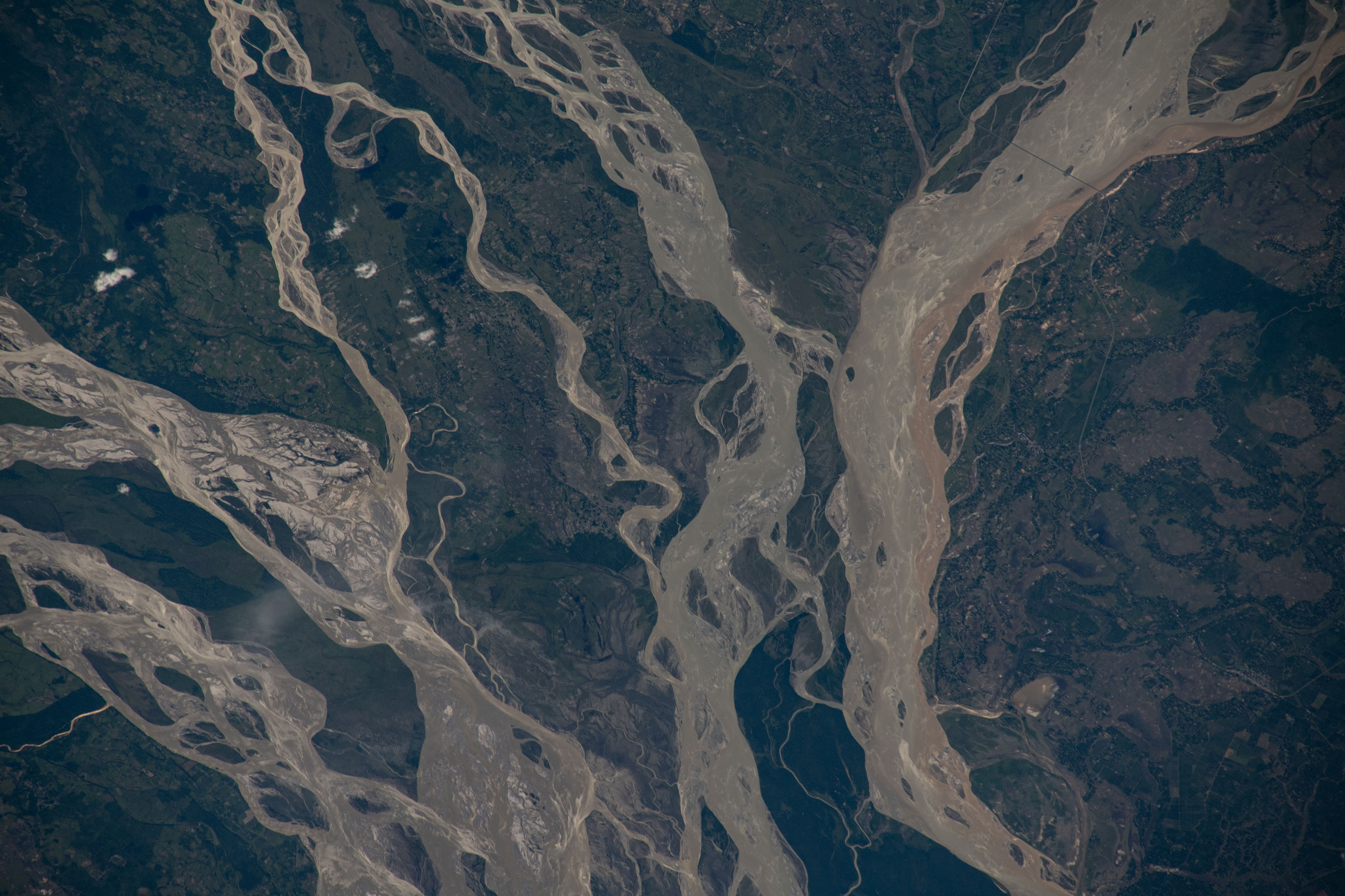


Photo center point: 27.8° N, 95.5° E
Photo center point by machine learning: 27.83° N, 95.55° E

Country or Geographic Name: | INDIA |
Features: | BRAHMAPUTRA RIVER, DIBRU SAIKHOWA NATIONAL PARK |
| Features Found Using Machine Learning: | |
Cloud Cover Percentage: | 10 (1-10)% |
Sun Elevation Angle: | 49° |
Sun Azimuth: | 273° |
Camera: | Nikon D5 Electronic Still Camera |
Focal Length: | 500mm |
Camera Tilt: | 18 degrees |
Format: | 5568E: 5568 x 3712 pixel CMOS sensor, 35.9 x 23.9 mm, total pixels: 21.33 million, Nikon FX format |
Film Exposure: | |
| Additional Information | |
| Width | Height | Annotated | Cropped | Purpose | Links |
|---|---|---|---|---|---|
| 3712 pixels | 5568 pixels | No | No | NASA's Earth Observatory web site | Download Image |
| 720 pixels | 900 pixels | Yes | No | NASA's Earth Observatory web site | Download Image |
| 720 pixels | 900 pixels | Yes | No | NASA's Earth Observatory web site | Download Image |
| 5568 pixels | 3712 pixels | No | No | Download Image | |
| 640 pixels | 427 pixels | No | No | Download Image |
An astronaut took this near-nadir photograph of one of Asia's largest rivers, the Brahmaputra. The mighty river appears as two major channels; several small islands sit within them and a large island separates them. Together they form a Brahmaputra floodplain that measures fully 10 kilometers (6 miles) in width. The channels appear brighter than those of the other rivers in this photo because they are near the Sun's glint point.
Two big tributaries, the Dibang and Lohit Rivers, flow nearby and join the Brahmaputra just outside the photo to the left. (The flow of the rivers in this scene is broadly west.) The Brahmaputra eventually joins the Ganges River in Bangladesh about 850 kilometers (525 miles) to the southwest, and both empty into the Bay of Bengal. The Brahmaputra is Asia's second largest river by discharge, after the Changjiang River in China. As measured at its confluence with the Ganges, the Brahmaputra River discharges 612 billion cubic meters per year, or 135 trillion gallons.
South Asia's monsoon rainfall regime brings heavy rain to this part of India from March through June, feeding the river and floodplain. Tropical forest is the natural vegetation of this landscape.
Human-built features seem minuscule here compared to the river channels. Most of the area includes land under cultivation, which appears as numerous small and irregular plots. Farms along the riverbanks are especially prone to damage and destruction by floods and by the persistent erosion of the banks. Linear features include roads and a 4-kilometer (2.4 mile) long bridge crossing the Lohit River.
Note, however, that the sector of the Brahmaputra floodplain (top left) displays no agricultural plots. It is a protected natural area within the Daying Ering (also known as D'Ering) Memorial Wildlife Sanctuary.
