ISS061-E-113632
| NASA Photo ID | ISS061-E-113632 |
| Focal Length | 50mm |
| Date taken | 2020.01.03 |
| Time taken | 07:59:16 GMT |
5011 x 3341 pixels 720 x 480 pixels 5568 x 3712 pixels 640 x 427 pixels

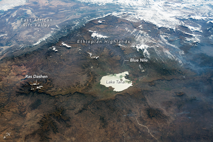


Photo center point: 12.0° N, 38.0° E
Photo center point by machine learning:
Country or Geographic Name: | ETHIOPIA |
Features: | TANA LAKE, SUNGLINT, ETHIOPIAN HIGHLANDS |
| Features Found Using Machine Learning: | |
Cloud Cover Percentage: | 25 (11-25)% |
Sun Elevation Angle: | 41° |
Sun Azimuth: | 144° |
Camera: | Nikon D5 Electronic Still Camera |
Focal Length: | 50mm |
Camera Tilt: | High Oblique |
Format: | 5568E: 5568 x 3712 pixel CMOS sensor, 35.9 x 23.9 mm, total pixels: 21.33 million, Nikon FX format |
Film Exposure: | |
| Additional Information | |
| Width | Height | Annotated | Cropped | Purpose | Links |
|---|---|---|---|---|---|
| 5011 pixels | 3341 pixels | Yes | No | Download Image | |
| 720 pixels | 480 pixels | Yes | No | Download Image | |
| 5568 pixels | 3712 pixels | No | No | Download Image | |
| 640 pixels | 427 pixels | No | No | Download Image |
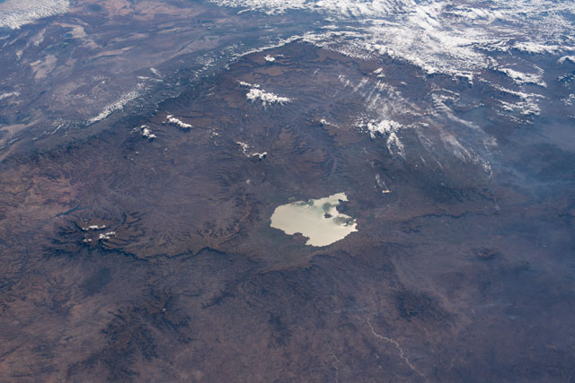
While in orbit over central Sudan, an astronaut on the International Space Station took this photograph featuring Lake Tana and the Ethiopian Highlands. The oblique angle and shadows help emphasize the rugged terrain of the Ethiopian Plateau, while Lake Tana, the largest lake in Ethiopia, appears mirror-like due to sunglint. The low-lying, tectonically active East African Rift Valley is bounded by the eastern edge of the Ethiopian Highlands.
The Semien (or Simien) Mountains tower over the plateau. With a peak rising 4,533 meters (14,926 feet) above sea level, Ras Dashen is the highest point in Ethiopia. Much of the Ethiopian Highlands are part of a large igneous province—a region with a significant accumulation of large lava rocks. The Semien Range was formed due to volcanic activity about 31 million years ago.
Although the highlands are surrounded by deserts, their elevation results in a temperate climate with ample rainfall. Lake Tana and its tributaries support an important fishing industry, in addition to agriculture in the surrounding wetlands. The lake also feeds the Blue Nile, which runs through northern Ethiopia and southern Sudan and delivers water to many communities. The river flows out of the south side of Lake Tana, through lower canyon areas south of the lake, and then east to ultimately join the White Nile in Sudan.
