ISS059-E-517

| NASA Photo ID | ISS059-E-517 |
| Focal Length | 24mm |
| Date taken | 2019.03.17 |
| Time taken | 12:39:37 GMT |
5568 x 3712 pixels 720 x 480 pixels 5568 x 3712 pixels 640 x 427 pixels

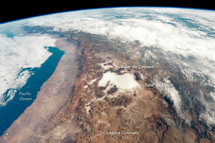
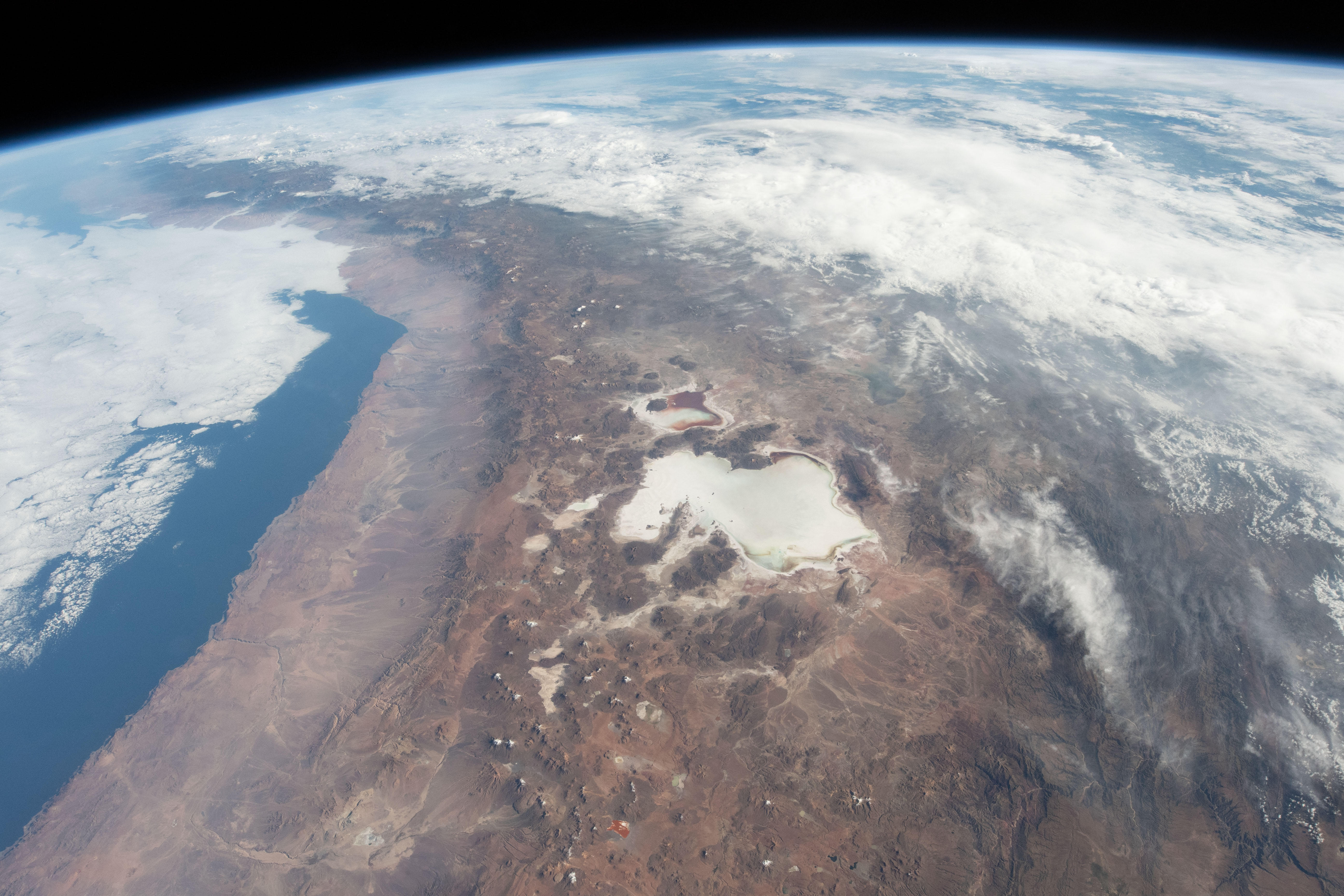

Photo center point: 20.0° S, 68.0° W
Photo center point by machine learning:
Country or Geographic Name: | BOLIVIA |
Features: | PAN- SALAR DE UYUNI, ATACAMA DESERT, ANDES, CHILE |
| Features Found Using Machine Learning: | |
Cloud Cover Percentage: | 50 (26-50)% |
Sun Elevation Angle: | 28° |
Sun Azimuth: | 79° |
Camera: | Nikon D5 Electronic Still Camera |
Focal Length: | 24mm |
Camera Tilt: | 42 degrees |
Format: | 5568E: 5568 x 3712 pixel CMOS sensor, 35.9 x 23.9 mm, total pixels: 21.33 million, Nikon FX format |
Film Exposure: | |
| Additional Information | |
| Width | Height | Annotated | Cropped | Purpose | Links |
|---|---|---|---|---|---|
| 5568 pixels | 3712 pixels | No | No | NASA's Earth Observatory web site | Download Image |
| 720 pixels | 480 pixels | Yes | Yes | NASA's Earth Observatory web site | Download Image |
| 5568 pixels | 3712 pixels | No | No | Download Image | |
| 640 pixels | 427 pixels | No | No | Download Image |
While orbiting over South America, an astronaut on the International Space Station shot this photograph of the Atacama Desert and the numerous salt flats in the Andes Mountains along the border of Chile and Bolivia. The centerpiece is the Salar de Uyuni, the largest salt flat on Earth. It regularly captures the attention of astronauts due to its high contrast against the brown landscape.
Salar de Uyuni and its smaller neighbor, Salar de Coipasa, have darker tones along their edges in this image. These dried lake beds are typically bright white in color, but rainfall can bring an influx of dark volcanic sediments. The region experienced rainfall in early February 2019, which caused temporary discoloration of the salars. By the time this image was taken in March 2019, the flats had started to shift back to their lighter colors.
Nearby, the much smaller Laguna Colorada displays bright hues thanks to algae that thrive in the salty water. To the west and northwest of the lake, some of the white dots are snow-capped volcanoes and mountains.
The salars receive less than 200 millimeters of rainfall per year. In contrast, the cloud-covered parts of Bolivia (north of the salars) see more than 1,750 mm of rain annually. The Andes Mountains create a rain shadow effect along the coast of northern Chile and western Bolivia, as air masses carrying moisture from the east drop most of their water before cooling and moving up over the mountains.
Along the coast, the Atacama Desert is one of the driest places on Earth, sometimes going years without rainfall. NASA uses the Atacama Desert to test rovers and other instruments because the area is a good analogue for future astrobiological exploration of Mars.
