ISS056-E-94529
| NASA Photo ID | ISS056-E-94529 |
| Focal Length | 800mm |
| Date taken | 2018.07.10 |
| Time taken | 15:26:09 GMT |
5568 x 3712 pixels 720 x 480 pixels 5568 x 3712 pixels 640 x 427 pixels

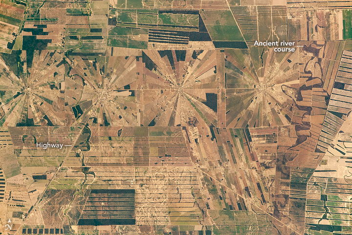


Photo center point: 17.4° S, 62.5° W
Photo center point by machine learning:
Country or Geographic Name: | BOLIVIA |
Features: | DEFORESTATION, AGRICULTURE FIELDS |
| Features Found Using Machine Learning: | |
Cloud Cover Percentage: | 10 (1-10)% |
Sun Elevation Angle: | 49° |
Sun Azimuth: | 20° |
Camera: | Nikon D5 Electronic Still Camera |
Focal Length: | 800mm |
Camera Tilt: | 27 degrees |
Format: | 5568E: 5568 x 3712 pixel CMOS sensor, 35.9 x 23.9 mm, total pixels: 21.33 million, Nikon FX format |
Film Exposure: | |
| Additional Information | |
| Width | Height | Annotated | Cropped | Purpose | Links |
|---|---|---|---|---|---|
| 5568 pixels | 3712 pixels | No | No | NASA's Earth Observatory web site | Download Image |
| 720 pixels | 480 pixels | Yes | Yes | NASA's Earth Observatory web site | Download Image |
| 5568 pixels | 3712 pixels | No | No | Download Image | |
| 640 pixels | 427 pixels | No | No | Download Image |
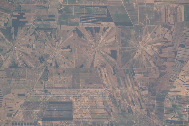
An astronaut aboard the International Space Station (ISS) focused a long lens on what may be a unique pattern on Earth for its size and repetitiveness. This series of adjacent agricultural fields is divided into square plots 4.4 kilometers wide, and each square has a "pinwheel" of triangular fields that radiate from a center point.
The square plots are part of a major resettlement project in Bolivia. The project was intended to help people from the Andes Mountains make a living through agriculture in the forested lowlands - the Tierras Bajas east of the Andes and northeast of the capital city, Santa Cruz de la Sierra.
Four such square plots occupy the middle of the image within the surrounding older patchwork pattern of linear fields. Small settlements occupy the center of each square. One of Bolivia's main highways angles across a square through this settlement. The straight highway contrasts with the highly sinuous course of an ancient river nearby. Other ancient channels appear along the right side of the image.
Geologists now know that all of these channels are remnants of the Rio Grande, a large river that drains out of the Andes. Over thousands of years this river has deposited the sediment that makes the very large flat plain ideal for agriculture. The river also provides access to near-surface water and allows easy transport in all directions.
An earlier photograph taken by astronauts in 2001 shows a larger group of the same unique patterns, but much less filled out. A comparison of images from 1986 to 2001 shows the rapid deforestation that cut out the squares.
