ISS055-E-31251

| NASA Photo ID | ISS055-E-31251 |
| Focal Length | 1600mm |
| Date taken | 2018.04.22 |
| Time taken | 15:40:14 GMT |
720 x 1080 pixels 3712 x 5568 pixels 720 x 1080 pixels 3712 x 5568 pixels 427 x 640 pixels

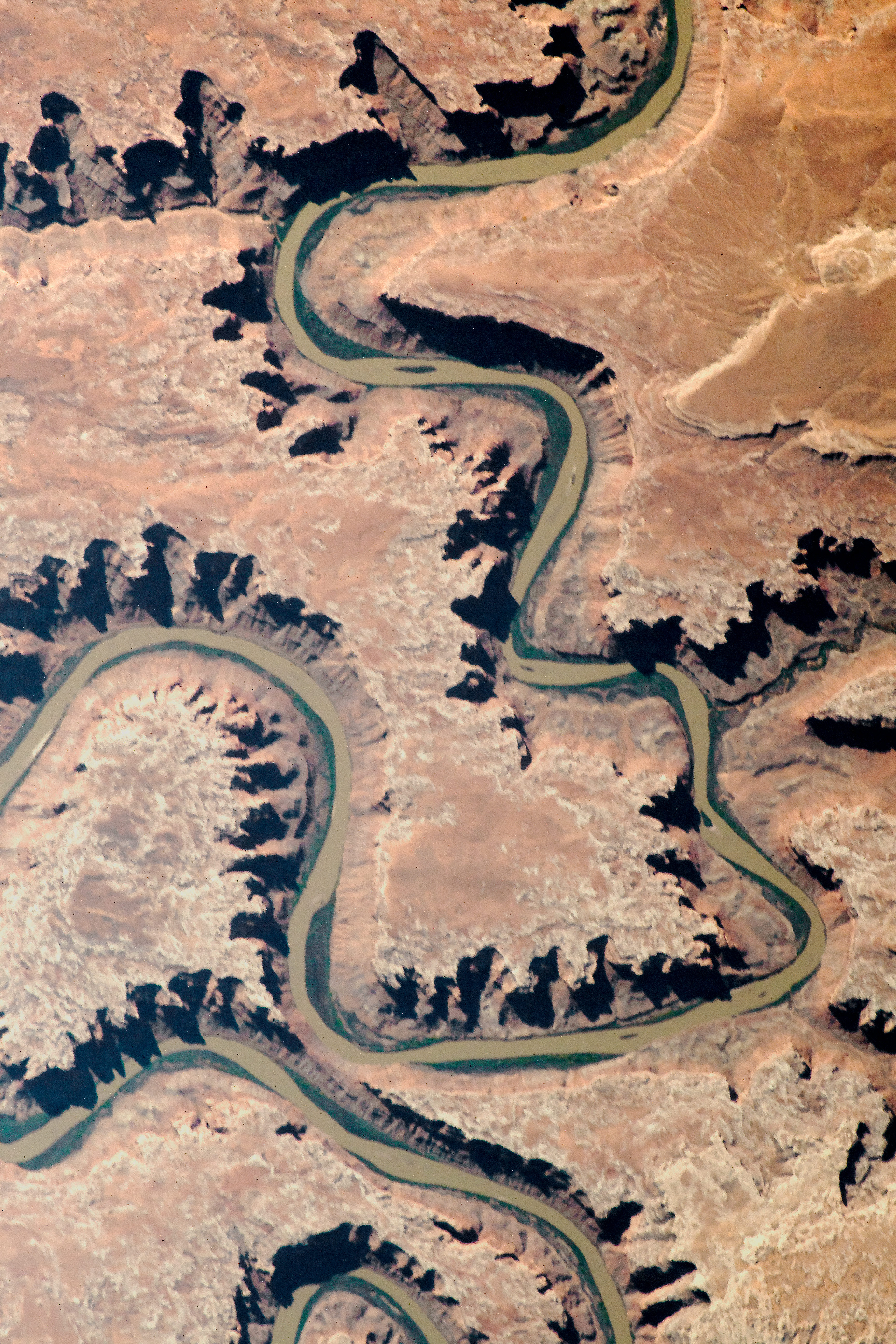
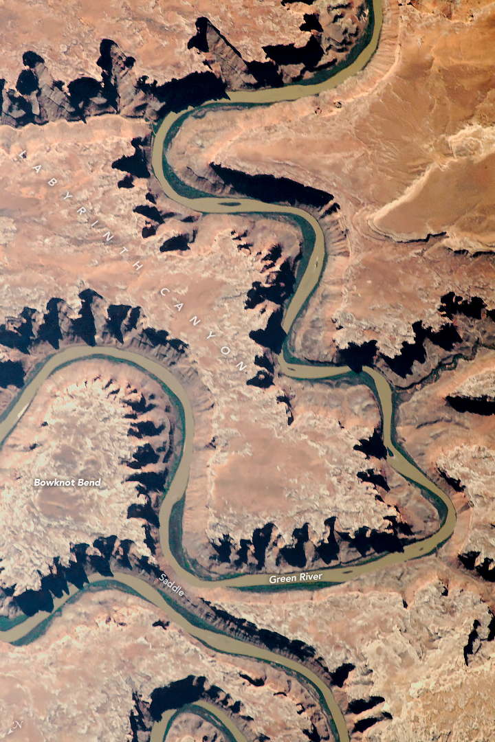
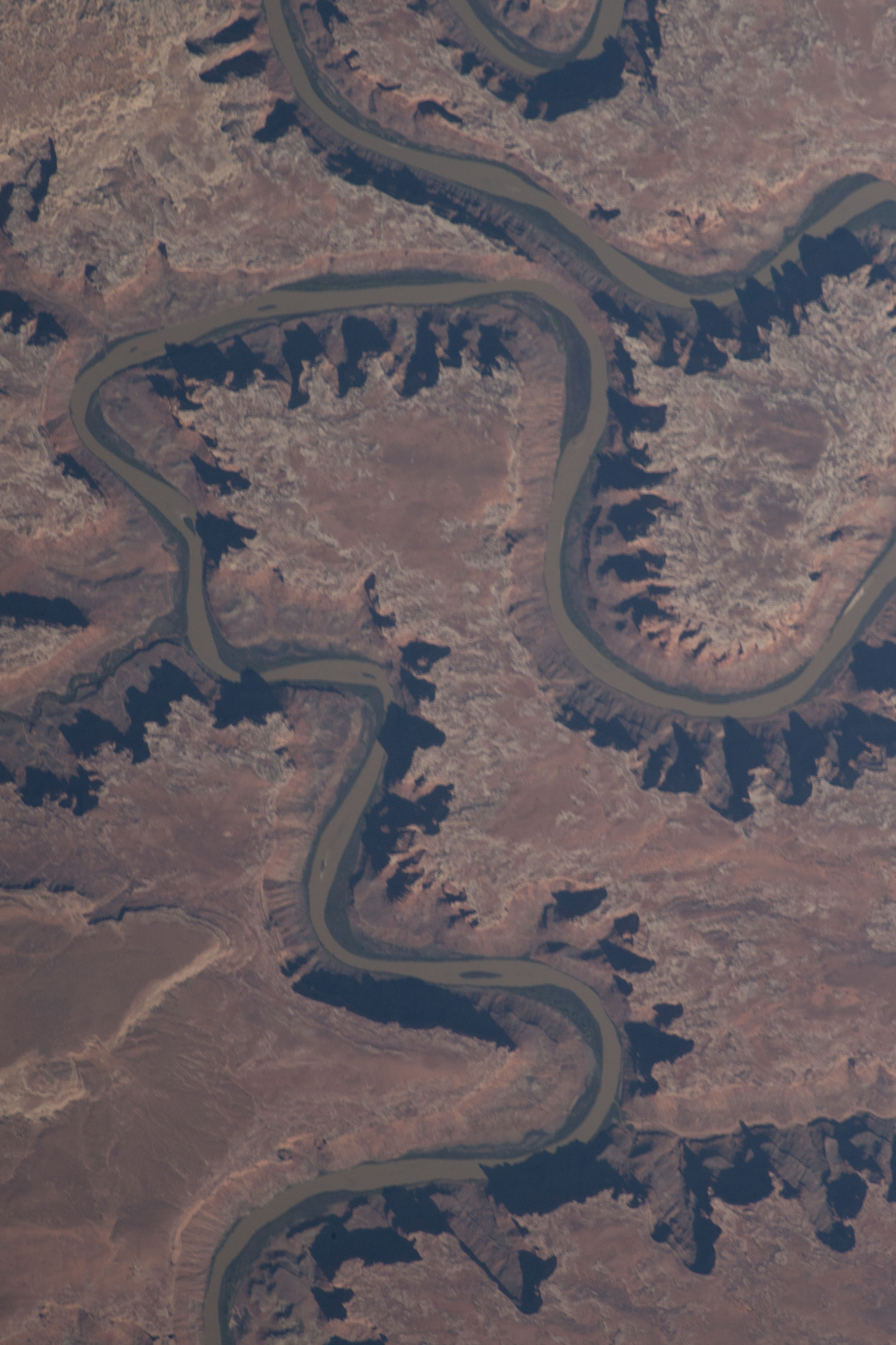

Photo center point: 38.6° N, 110.0° W
Photo center point by machine learning:
Country or Geographic Name: | USA-UTAH |
Features: | GREEN RIVER |
| Features Found Using Machine Learning: | |
Cloud Cover Percentage: | 10 (1-10)% |
Sun Elevation Angle: | 34° |
Sun Azimuth: | 103° |
Camera: | Nikon D5 Electronic Still Camera |
Focal Length: | 1600mm |
Camera Tilt: | 14 degrees |
Format: | 5568E: 5568 x 3712 pixel CMOS sensor, 35.9 x 23.9 mm, total pixels: 21.33 million, Nikon FX format |
Film Exposure: | |
| Additional Information | |
| Width | Height | Annotated | Cropped | Purpose | Links |
|---|---|---|---|---|---|
| 720 pixels | 1080 pixels | Yes | Yes | NASA's Earth Observatory web site | Download Image |
| 3712 pixels | 5568 pixels | No | No | NASA's Earth Observatory web site | Download Image |
| 720 pixels | 1080 pixels | Yes | No | NASA's Earth Observatory web site | Download Image |
| 3712 pixels | 5568 pixels | No | No | Download Image | |
| 427 pixels | 640 pixels | No | No | Download Image |
An astronaut aboard the International Space Station shot this photograph of the Green River flowing through red rock canyons in eastern Utah. A main tributary of the Colorado River, the Green flows 730 miles (1175 kilometers) through Wyoming, Colorado, and Utah. The portion of the Green River in this image is just north of Canyonlands National Park.
Bowknot Bend was named by John Wesley Powell in 1869 during his first expedition through the region because of the way the river loops back on itself. Located in Labyrinth Canyon about 25 miles west of Moab, Utah, this river bend runs 7.5 miles (12 kilometers) in a circular loop and ends up 1,200 feet (360 meters) from where it first started, on the opposite side of a narrow saddle. When the two sides of the river cut through the saddle and merge someday, Bowknot Bend will break off from the main channel and form an oxbow lake.
High contrast from the dark shadows along the river give some three-dimensional perspective to the 1,000 foot (300 meter) canyons that have deepened over geologic time from erosion. Similar to the formation of the Grand Canyon, Labyrinth Canyon started to form when regional uplift of the Colorado Plateau caused the Green River to cut down through the rocks to its current depth. Some inactive uranium mines, such as the Aileen Mine, are located along the canyon walls. Uranium ore deposits are concentrated in much older fluvial sandstones.
Bowknot Bend is a popular destination for hiking, canyoneering, and river rafting. Visitors can explore the multitude of caves and alcoves located within Labyrinth Canyon. They also hike to various lookouts, particularly the saddle of Bowknot Bend. Several sections of the Green River can be rafted, kayaked, or canoed until it meets with the Colorado River (south of this image).
