ISS054-E-54281

| NASA Photo ID | ISS054-E-54281 |
| Focal Length | 17mm |
| Date taken | 2018.02.25 |
| Time taken | 12:52:28 GMT |
5568 x 3712 pixels 720 x 480 pixels 5568 x 3712 pixels 640 x 427 pixels
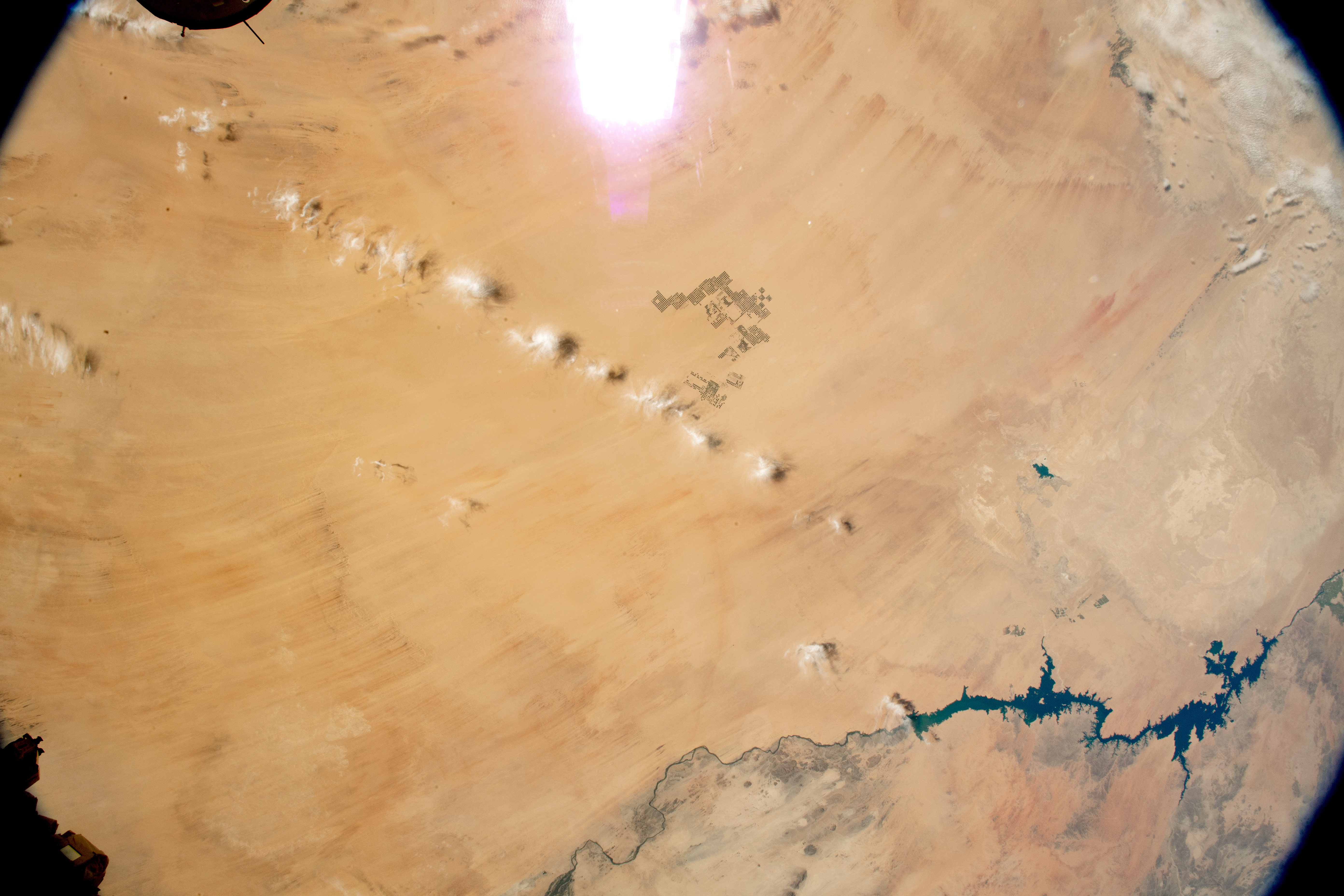
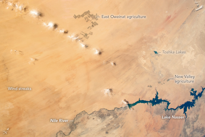

Photo center point: 22.0° N, 29.0° E
Photo center point by machine learning:
Country or Geographic Name: | SUDAN |
Features: | LAKE NASSER, TOSHKA LAKES, LIBYAN DESERT, SAHARA DESERT |
| Features Found Using Machine Learning: | PAN- |
Cloud Cover Percentage: | 10 (1-10)% |
Sun Elevation Angle: | 42° |
Sun Azimuth: | 234° |
Camera: | Nikon D5 Electronic Still Camera |
Focal Length: | 17mm |
Camera Tilt: | 14 degrees |
Format: | 5568E: 5568 x 3712 pixel CMOS sensor, 35.9 x 23.9 mm, total pixels: 21.33 million, Nikon FX format |
Film Exposure: | |
| Additional Information | |
| Width | Height | Annotated | Cropped | Purpose | Links |
|---|---|---|---|---|---|
| 5568 pixels | 3712 pixels | No | No | NASA's Earth Observatory web site | Download Image |
| 720 pixels | 480 pixels | Yes | Yes | NASA's Earth Observatory web site | Download Image |
| 5568 pixels | 3712 pixels | No | No | Download Image | |
| 640 pixels | 427 pixels | No | No | Download Image |
An astronaut aboard the International Space Station shot this photograph of the vast expanse of Egypt's Western Desert, just west of the Nile River. This oblique view shows almost the entire southern half of Egypt, with a swath of parallel wind streaks marking the arid landscape. A line of small clouds casts shadows on the desert below.
Two darker patches in the photo stand out against the light desert sand. These are large agricultural projects at East Oweinat and Toshka New Valley, near Lake Nasser. Approximately one-third of the Egyptian labor force works in farming, with most agricultural production concentrated along the Nile Valley. The pioneering agricultural projects shown above were planned to encourage people to leave the very heavily populated Nile Delta and to seek economic opportunities in the desert.
The New Valley farming project draws its water from the Toshka Lakes. Development began in the late 1990s. By the early 2000s, water levels dropped and the area of the lakes had shrunk (as did neighboring Lake Nasser) due to lower water inputs for a number of years. The lakes are barely discernable in this image.
Fresh water for East Oweinat is pumped from underground aquifers, and it is a non-renewable resource. The fossil water underground accumulated between 20,000 and 5,000 years ago when the Sahara was much wetter.
Related Images
- NASA Earth Observatory (2017, September 18) Crop Circles in Sharq El Owainat.
- NASA Earth Observatory (2006, January 2) Lake Nasser and the New Valley.
- NASA Earth Observatory (2001, April 22) Another New Lake in Egypt.
