ISS052-E-53588
| NASA Photo ID | ISS052-E-53588 |
| Focal Length | 78mm |
| Date taken | 2017.08.14 |
| Time taken | 23:54:16 GMT |
4928 x 3280 pixels 720 x 480 pixels 4928 x 3280 pixels 640 x 426 pixels

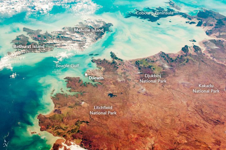


Photo center point: 12.5° S, 131.0° E
Photo center point by machine learning:
Country or Geographic Name: | AUSTRALIA-NT |
Features: | VAN DIEMAN GULF, BEAGLE GULF, MELVILLE ISLAND, BATHURST ISLAND, COBOURG |
| Features Found Using Machine Learning: | |
Cloud Cover Percentage: | 10 (1-10)% |
Sun Elevation Angle: | 30° |
Sun Azimuth: | 63° |
Camera: | Nikon D4 Electronic Still Camera |
Focal Length: | 78mm |
Camera Tilt: | 43 degrees |
Format: | 4928E: 4928 x 3280 pixel CMOS sensor, 36.0mm x 23.9mm, total pixels: 16.6 million, Nikon FX format |
Film Exposure: | |
| Additional Information | |
| Width | Height | Annotated | Cropped | Purpose | Links |
|---|---|---|---|---|---|
| 4928 pixels | 3280 pixels | No | No | NASA's Earth Observatory web site | Download Image |
| 720 pixels | 480 pixels | Yes | No | NASA's Earth Observatory web site | Download Image |
| 4928 pixels | 3280 pixels | No | No | Download Image | |
| 640 pixels | 426 pixels | No | No | Download Image |
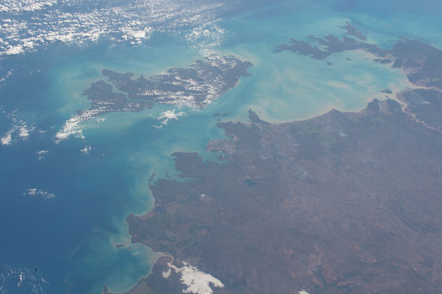
An astronaut aboard the International Space Station captured this photograph of the northernmost portion of Australia's Northern Territory, including Melville, Bathurst, and several other Tiwi Islands. With an area of 5,786 square kilometers (2,234 square miles), Melville is the largest Australian island.
Northern Territory is an Australian federal division characterized by open, sparsely populated land that ranges from wetlands in the north to desert in the south. Rivers flow north from higher elevations to a relatively flat coast and carry reddish-tan sediment into the sea, coloring the waters. As in other Australian territories, most of the population resides along the coast. Darwin is the capital and largest city in the area, with an estimated population over 148,000 (as of 2017).
Although the first settlers of this area were indigenous Australians, many of the place names come from explorers and the days of European settlement in the early 1800s. For example, Beagle Gulf is named after the HMS Beagle, the vessel that Charles Darwin famously sailed on. The Port of Darwin was named after the well-known evolutionary biologist even though he never visited the region.
Travelling inland, a large portion of the territory is designated as national park or conservation land. Kakadu National Park is the largest national park in Australia. Djukbinj National Park, approximately 80 kilometers (50 miles) east of Darwin, is mainly comprised of wetlands. Litchfield National Park attracts tourists with several waterfalls, the Blyth Homestead (a 1920s remnant of a typical pioneer home), and enormous termite mounds. The Cobourg Peninsula (top right) separates the Arafura Sea and Van Diemen Gulf and is designated as the Garig Gunak National Park.
