ISS044-E-89407
| NASA Photo ID | ISS044-E-89407 |
| Focal Length | 1150mm |
| Date taken | 2015.09.06 |
| Time taken | 04:27:22 GMT |
Resolutions offered for this image:
1000 x 666 pixels 540 x 360 pixels 4928 x 3280 pixels 720 x 480 pixels 4928 x 3280 pixels 640 x 426 pixels
1000 x 666 pixels 540 x 360 pixels 4928 x 3280 pixels 720 x 480 pixels 4928 x 3280 pixels 640 x 426 pixels


Spacecraft nadir point: 43.5° N, 119.5° E
Photo center point: 39.5° N, 122.5° E
Photo center point by machine learning:
Photo center point: 39.5° N, 122.5° E
Photo center point by machine learning:
Nadir to Photo Center: Southeast
Spacecraft Altitude: 213 nautical miles (394km)
Country or Geographic Name: | CHINA |
Features: | NUMEROUS FISH FARMS, GLINT, BILIU R. |
| Features Found Using Machine Learning: | |
Cloud Cover Percentage: | 10 (1-10)% |
Sun Elevation Angle: | 53° |
Sun Azimuth: | 191° |
Camera: | Nikon D4 Electronic Still Camera |
Focal Length: | 1150mm |
Camera Tilt: | 55 degrees |
Format: | 4928E: 4928 x 3280 pixel CMOS sensor, 36.0mm x 23.9mm, total pixels: 16.6 million, Nikon FX format |
Film Exposure: | |
| Additional Information | |
| Width | Height | Annotated | Cropped | Purpose | Links |
|---|---|---|---|---|---|
| 1000 pixels | 666 pixels | No | No | Earth From Space collection | Download Image |
| 540 pixels | 360 pixels | Yes | No | Earth From Space collection | Download Image |
| 4928 pixels | 3280 pixels | No | No | NASA's Earth Observatory web site | Download Image |
| 720 pixels | 480 pixels | Yes | No | NASA's Earth Observatory web site | Download Image |
| 4928 pixels | 3280 pixels | No | No | Download Image | |
| 640 pixels | 426 pixels | No | No | Download Image |
Download Packaged File
Download a Google Earth KML for this Image
View photo footprint information
Download a GeoTIFF for this photo
Georeferenced by human interaction - exported 2016-08-17-011139-UTCGeoreferenced by human interaction - exported 2016-08-24-020624-UTC
Georeferenced by human interaction - exported 2018-01-16-171944-UTC
An explanation of the georeference file(s) above
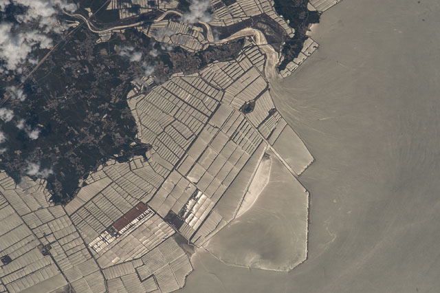
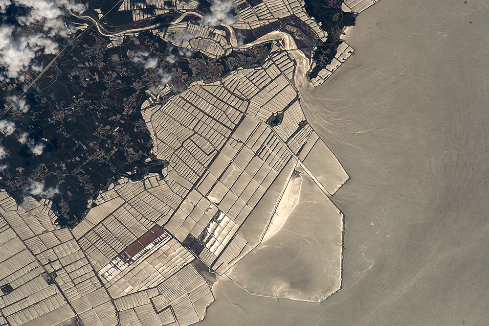
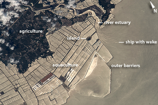
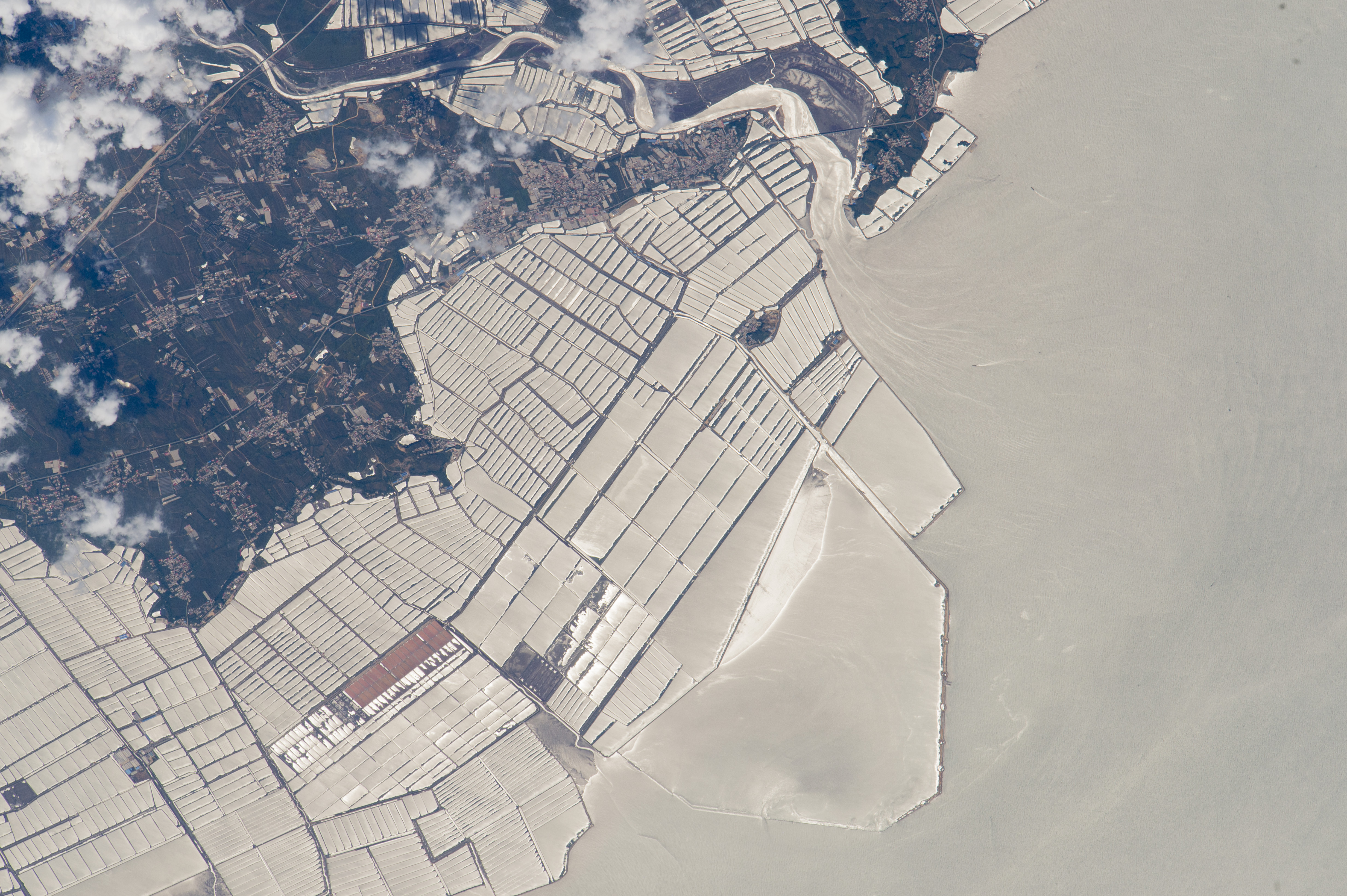
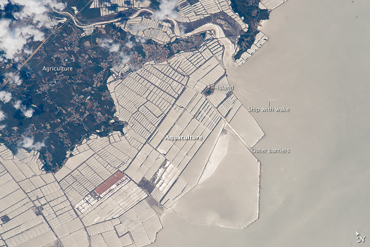
Image Caption: Fish farms basins, NE China
Astronauts aboard the International Space Station looked near the sun's reflection point to shoot this high-contrast grid pattern of fish farms on the coast of China's northeast province of Liaoning. The fish-farm basins have been built out from the dark-toned, wooded coast to a distance of nearly 6 km (4 mi)(image top left). Fish farms have been constructed at very many points along the province's coastline, but this group of basins, facing the Yellow Sea, is the largest (Liaoning Province is the sixth in China in terms of aquaculture production) Basins are built on shallow seabeds, mudflats and bays. Islands commonly help anchor the construction of basins--one island is shown here (image center). Outer barriers (image lower right) protect the basins from winter storms. Water flow lines and a ship wake can be seen at the river estuary (image top right).
Most aquaculture products are marketed live in China, with less than 5% processed for local or overseas markets. Shellfish, a traditional marine food source, still dominates the marine species production (77%), with sea fish a distant second (5%) having been promoted only in the 1990s. About 4.3 million people are involved in fresh-water and marine fish production in China (2007 data).
Another high contrast astronaut image of fish farms near the Nile delta can be seen here.
