ISS044-E-44327
| NASA Photo ID | ISS044-E-44327 |
| Focal Length | 1150mm |
| Date taken | 2015.08.08 |
| Time taken | 09:10:58 GMT |
1000 x 832 pixels 540 x 449 pixels 720 x 480 pixels 4928 x 3280 pixels 640 x 426 pixels
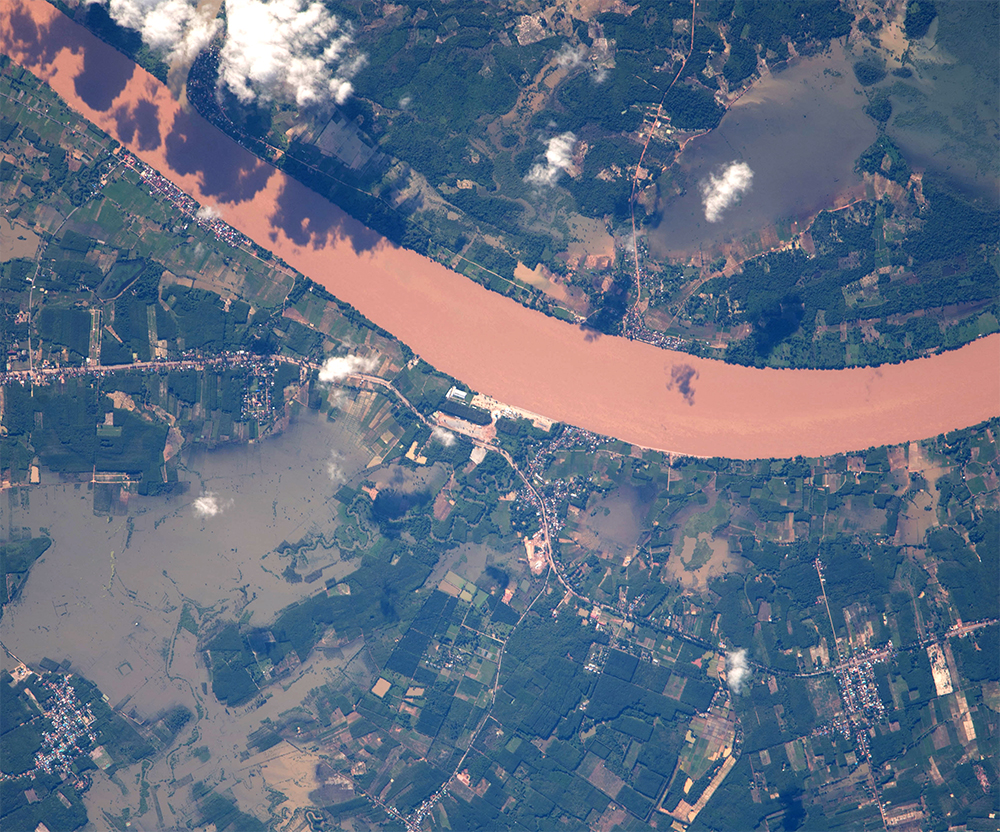
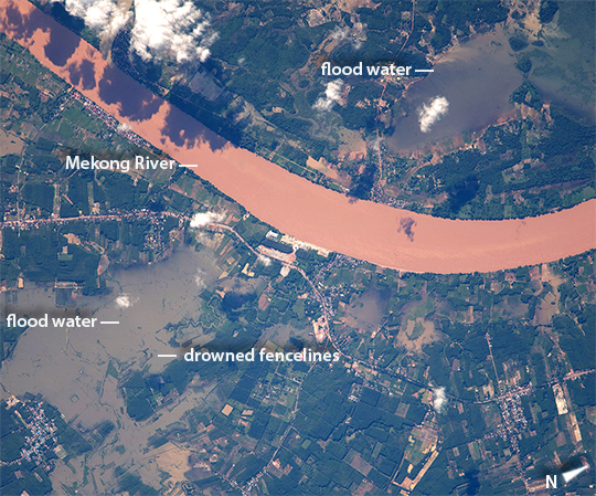
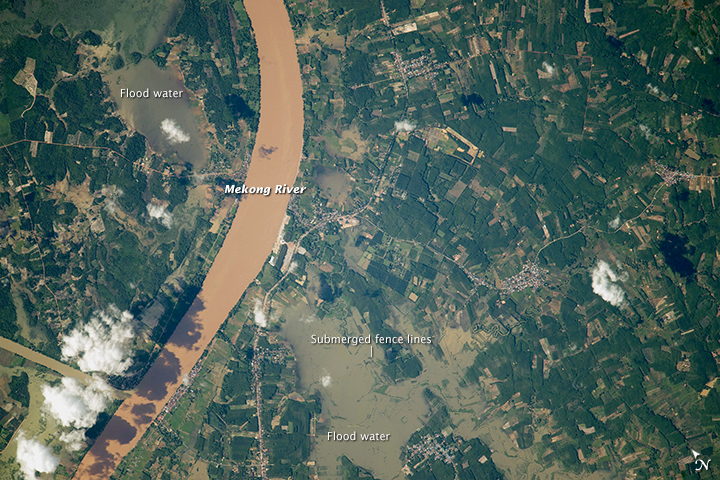


Photo center point: 18.1° N, 103.2° E
Photo center point by machine learning:
Country or Geographic Name: | THAILAND |
Features: | MEKONG R. IN FLOOD, FARMLAND, FLOODS |
| Features Found Using Machine Learning: | |
Cloud Cover Percentage: | 10 (1-10)% |
Sun Elevation Angle: | 34° |
Sun Azimuth: | 279° |
Camera: | Nikon D4 Electronic Still Camera |
Focal Length: | 1150mm |
Camera Tilt: | 41 degrees |
Format: | 4928E: 4928 x 3280 pixel CMOS sensor, 36.0mm x 23.9mm, total pixels: 16.6 million, Nikon FX format |
Film Exposure: | |
| Additional Information | |
| Width | Height | Annotated | Cropped | Purpose | Links |
|---|---|---|---|---|---|
| 1000 pixels | 832 pixels | No | No | Earth From Space collection | Download Image |
| 540 pixels | 449 pixels | Yes | No | Earth From Space collection | Download Image |
| 720 pixels | 480 pixels | Yes | No | NASA's Earth Observatory web site | Download Image |
| 4928 pixels | 3280 pixels | No | No | Download Image | |
| 640 pixels | 426 pixels | No | No | Download Image |
Georeferenced by human interaction - exported 2016-08-24-010449-UTC
Georeferenced by human interaction - exported 2018-01-16-161441-UTC
An explanation of the georeference file(s) above
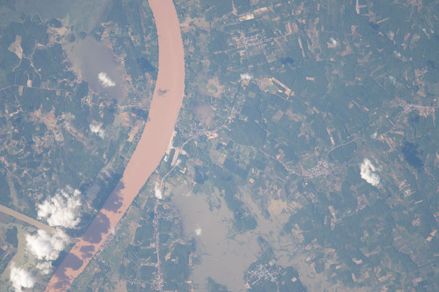
Astronauts aboard the International Space Station (ISS) took these detailed images of the Mekong River on the border between Thailand and Laos. The images show not only roads and buildings in great detail (in an area about 60 km northeast of Laos's capital city Vientiane), but also evidence of flooding. Southeast Asia's largest river winds as a red-brown channel of floodwater resulting from very heavy monsoon rainfall that affected populations from North Vietnam through Thailand and Myanmar to India, starting on 26 July. ISS crews have been specially tasked to document floods photographically--these photos represent the best of the kind imagery that NASA tries to gather to assist relief authorities on the ground.
Both images show flooded areas covering thousands of acres affecting farmland on the Mekong floodplain in zones far wider than Mekong River itself (650 meters, 2200 feet). The rectangular grid of fencelines sticks up above the level of the flood water in both images. Red-brown water on the farmland has been washed in from the hills and from the muddy water of the Mekong River. Clearer flood water in the lower image is rainwater that has ponded in the immediate area, and has collected no sediment to redden it.
