ISS041-E-16962

| NASA Photo ID | ISS041-E-16962 |
| Focal Length | 45mm |
| Date taken | 2014.09.18 |
| Time taken | 18:34:20 GMT |
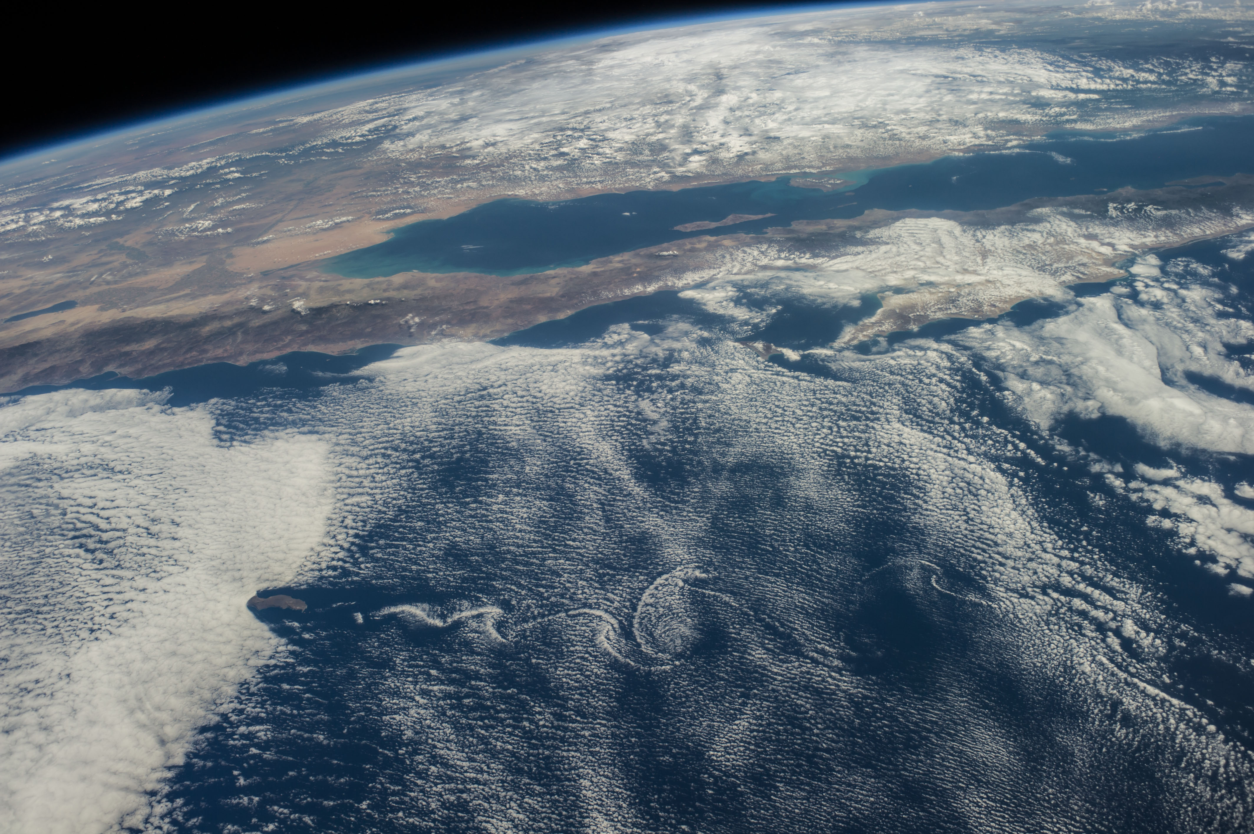
Spacecraft nadir point: 23.1° N, 120.0° W
Photo center point: 28.5° N, 116.0° W
Photo center point by machine learning:
Photo center point: 28.5° N, 116.0° W
Photo center point by machine learning:
Nadir to Photo Center: Northeast
Spacecraft Altitude: 222 nautical miles (411km)
Country or Geographic Name: | MEXICO |
Features: | BAJA CALIFORNIA, G. OF CALIFORNIA, SONORAN DES., SALTON S., ATMOSPHERIC LIMB |
| Features Found Using Machine Learning: | PAN- |
Cloud Cover Percentage: | 100 (76-100)% |
Sun Elevation Angle: | 61° |
Sun Azimuth: | 135° |
Camera: | Nikon D3S Electronic Still Camera |
Focal Length: | 45mm |
Camera Tilt: | High Oblique |
Format: | 4256E: 4256 x 2832 pixel CMOS sensor, 36.0mm x 23.9mm, total pixels: 12.87 million, Nikon FX format |
Film Exposure: | |
| Additional Information | |
| Width | Height | Annotated | Cropped | Purpose | Links |
|---|---|---|---|---|---|
| 4256 pixels | 2832 pixels | No | No | Download Image | |
| 640 pixels | 426 pixels | No | No | Download Image |
Download Packaged File
Download a Google Earth KML for this Image
View photo footprint information
Download a GeoTIFF for this photo
Image Caption: ISS041-E-016962 (18 Sept. 2014) --- Although land and waters of Mexico's Pacific area pictured here are influenced by masses of clouds, for Baja California and other parts of Mexico in this photograph made from the International Space Station, things are quite calmer than a few days ago when Hurricane Odile unleashed its power on the peninsula, especially Baja's south end (right side of frame) and Cabo San Lucas (just out of frame right). The Sea of Cortez (Gulf of California) experiences rather calm weather in this view. California's Salton Sea is visible at left center; and Guadalupe Island is visible at lower left, surrounded by von Karman vortices.
CATALOGED BY TEXAS STATE UNIVERSITY
CATALOGED BY TEXAS STATE UNIVERSITY
