ISS041-E-103711
| NASA Photo ID | ISS041-E-103711 |
| Focal Length | 800mm |
| Date taken | 2014.10.28 |
| Time taken | 17:04:07 GMT |
Resolutions offered for this image:
1000 x 666 pixels 540 x 418 pixels 4928 x 3280 pixels 640 x 426 pixels
1000 x 666 pixels 540 x 418 pixels 4928 x 3280 pixels 640 x 426 pixels


Spacecraft nadir point: 31.9° N, 105.9° W
Photo center point: 31.8° N, 106.5° W
Photo center point by machine learning:
Photo center point: 31.8° N, 106.5° W
Photo center point by machine learning:
Nadir to Photo Center: West
Spacecraft Altitude: 221 nautical miles (409km)
Country or Geographic Name: | MEXICO |
Features: | EL PASO, CIUDAD JUAREZ, RIO GRANDE |
| Features Found Using Machine Learning: | |
Cloud Cover Percentage: | 10 (1-10)% |
Sun Elevation Angle: | 39° |
Sun Azimuth: | 147° |
Camera: | Nikon D4 Electronic Still Camera |
Focal Length: | 800mm |
Camera Tilt: | 09 degrees |
Format: | 4928E: 4928 x 3280 pixel CMOS sensor, 36.0mm x 23.9mm, total pixels: 16.6 million, Nikon FX format |
Film Exposure: | |
| Additional Information | |
| Width | Height | Annotated | Cropped | Purpose | Links |
|---|---|---|---|---|---|
| 1000 pixels | 666 pixels | No | Yes | Earth From Space collection | Download Image |
| 540 pixels | 418 pixels | Yes | Yes | Earth From Space collection | Download Image |
| 4928 pixels | 3280 pixels | No | No | Download Image | |
| 640 pixels | 426 pixels | No | No | Download Image |
Download Packaged File
Download a Google Earth KML for this Image
View photo footprint information
Download a GeoTIFF for this photo
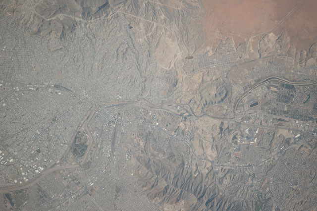
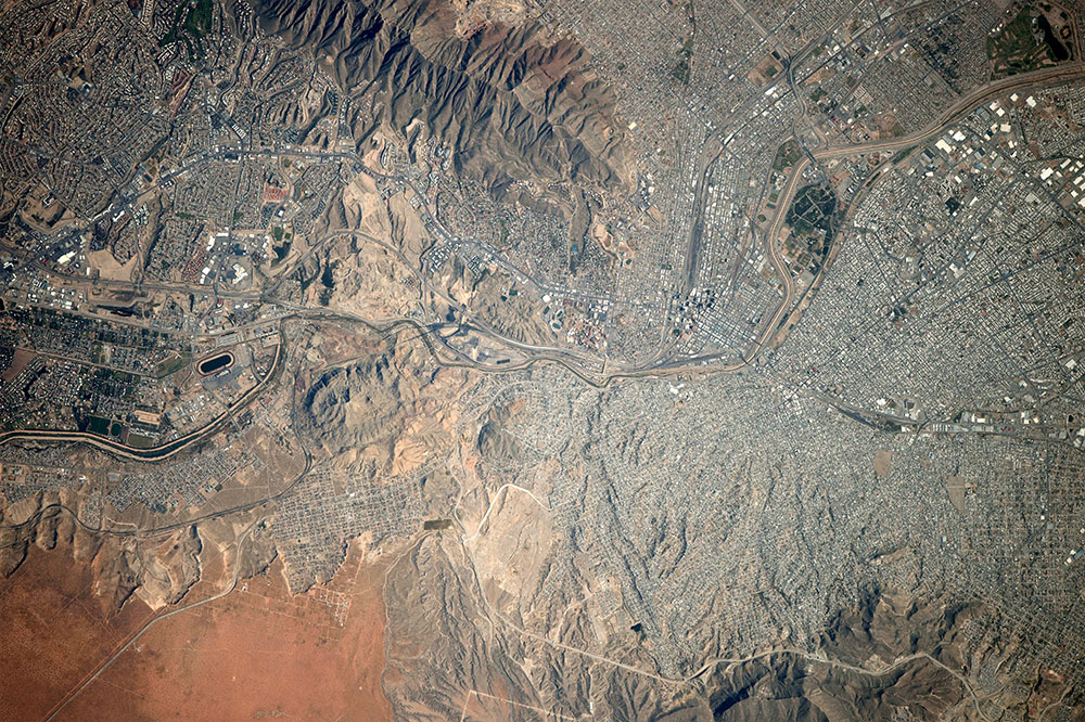
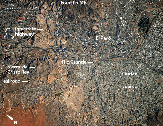
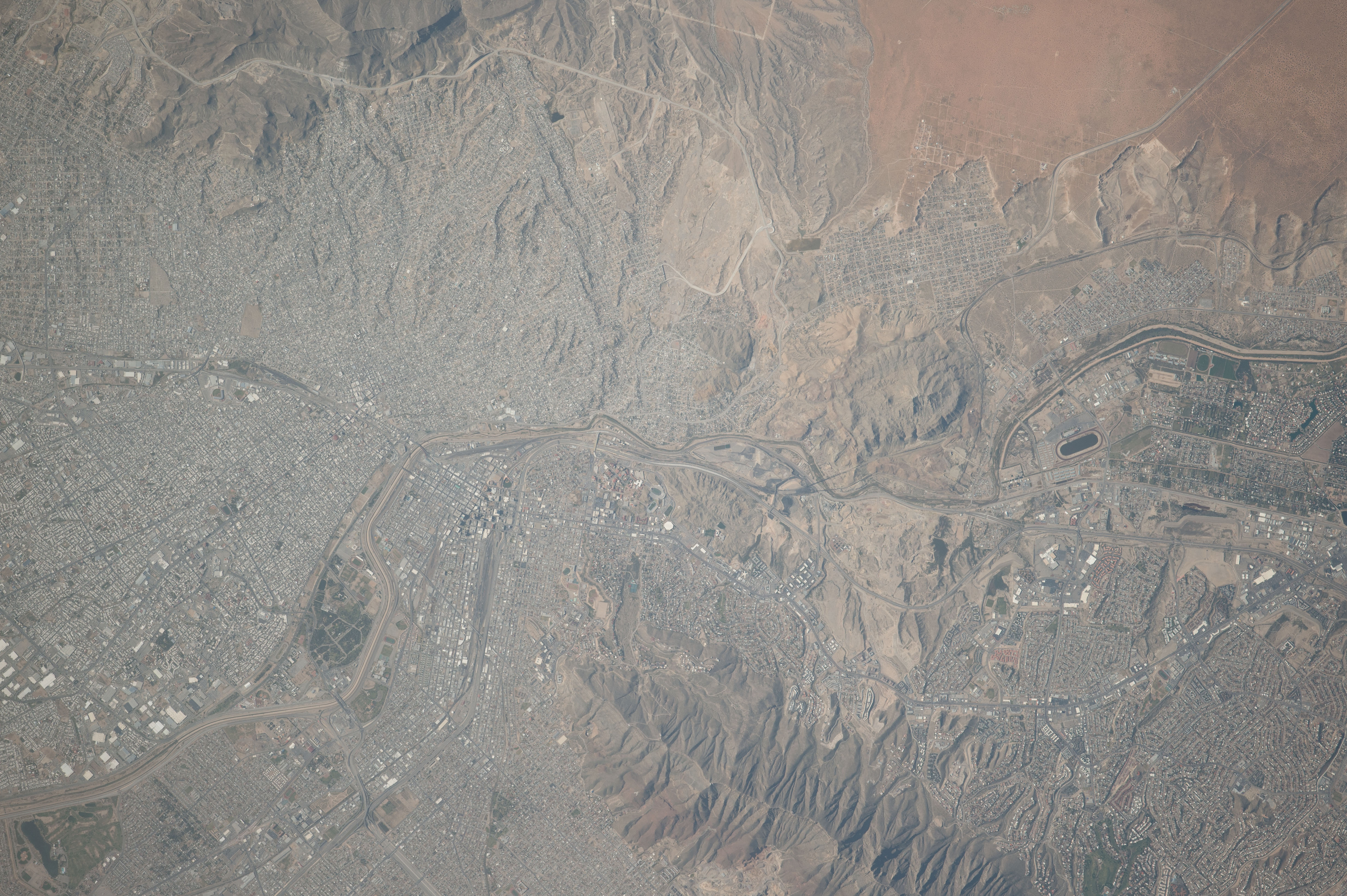
Image Caption: El Paso, USA and Ciudad Juarez, Mexico
Flying over the border between Mexico and the US, crew aboard the International Space Station photographed these sister cities on the Rio Grande--that combined make up the second largest metropolitan area (population of 2.7 million) on the Mexico-US border. The river crosses the image as a prominent line and acts as the international border upper left.
The name El Paso has been used for hundreds of years to indicate a gap in the mountains cut by the Rio Grande (known as the Rio Bravo del Norte in Mexico). This small gorge divides the Franklin Mountains within the US (image right) from hills in Mexico where the prominent Sierra Cristo Rey is topped by a statue of Christ. The gorge has been important for transportation for centuries. Railroads reached El Paso in the early 1880s. The transcontinental interstate highway--that joins the Atlantic coast in Florida to the west coast in southern California--also cuts through the gap in downtown El Paso.
Cityscapes are subtly different on each side of the border as seen from space. For example, wider streets and a more regular street grid are visible in the city of El Paso as compared to Juarez. The city centers lie close to the river opposite one another (image left center) with large residential areas covering the arid slopes in the rest of the scene.
