ISS040-E-6165
| NASA Photo ID | ISS040-E-6165 |
| Focal Length | 200mm |
| Date taken | 2014.05.31 |
| Time taken | 22:56:48 GMT |


Spacecraft nadir point: 44.8° S, 177.9° E
Photo center point: 43.8° S, 172.9° E
Photo center point by machine learning:
Photo center point: 43.8° S, 172.9° E
Photo center point by machine learning:
Nadir to Photo Center: West
Spacecraft Altitude: 228 nautical miles (422km)
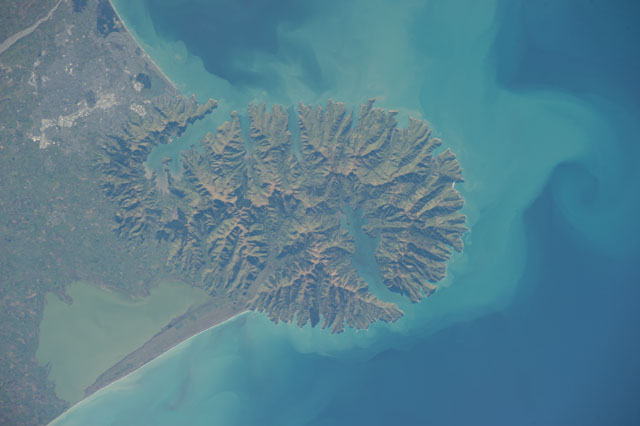
Country or Geographic Name: | NEW ZEALAND-SI |
Features: | PUBLIC INPUTS (from public image detectives, not NASA): NEW ZEALAND,BANKS PENINSULA,KAITORETE SPIT,LYTTELTON HARBOUR,WAIMAKARIN RIVER,TE WAIHORA(LAKE ELLESMERE),AKAROA HARBOUR,DUVAUCHELLE,CHRISTCHURCH,O.,L.,MTS. |
| Features Found Using Machine Learning: | |
Cloud Cover Percentage: | 10 (1-10)% |
Sun Elevation Angle: | 22° |
Sun Azimuth: | 17° |
Camera: | Nikon D3S Electronic Still Camera |
Focal Length: | 200mm |
Camera Tilt: | 53 degrees |
Format: | 4256E: 4256 x 2832 pixel CMOS sensor, 36.0mm x 23.9mm, total pixels: 12.87 million, Nikon FX format |
Film Exposure: | |
| Additional Information | |
| Width | Height | Annotated | Cropped | Purpose | Links |
|---|---|---|---|---|---|
| 4256 pixels | 2832 pixels | No | No | Download Image | |
| 640 pixels | 426 pixels | No | No | Download Image |
Download Packaged File
Download a Google Earth KML for this Image
View photo footprint information
Download a GeoTIFF for this photo
Image Caption: ISS040-E-006165 (31 May 2014 ) --- One of the Expedition 40 crew members aboard the International Space Station photographed this nadir image of the volcanic-born Banks Peninsula, on the east coast of the South Island of New Zealand on May 31, 2014. Banks Peninsula covers an area of approximately 1,150 square kilometers.
