ISS040-E-500
| NASA Photo ID | ISS040-E-500 |
| Focal Length | 200mm |
| Date taken | 2014.05.17 |
| Time taken | 16:45:19 GMT |


Spacecraft nadir point: 11.6° N, 65.2° W
Photo center point: 11.8° N, 66.7° W
Photo center point by machine learning:
Photo center point: 11.8° N, 66.7° W
Photo center point by machine learning:
Nadir to Photo Center: West
Spacecraft Altitude: 225 nautical miles (417km)
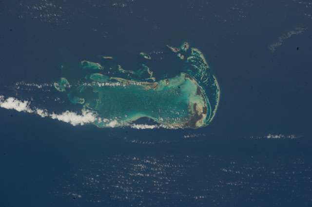
Country or Geographic Name: | VENEZUELA |
Features: | CARIBBBEAN S., LOS ROQUES ARCHIPELAGO, REEFS, LAGOONS, ISLETS |
| Features Found Using Machine Learning: | |
Cloud Cover Percentage: | 10 (1-10)% |
Sun Elevation Angle: | 80° |
Sun Azimuth: | 320° |
Camera: | Nikon D3S Electronic Still Camera |
Focal Length: | 200mm |
Camera Tilt: | 22 degrees |
Format: | 4256E: 4256 x 2832 pixel CMOS sensor, 36.0mm x 23.9mm, total pixels: 12.87 million, Nikon FX format |
Film Exposure: | |
| Additional Information | |
| Width | Height | Annotated | Cropped | Purpose | Links |
|---|---|---|---|---|---|
| 4256 pixels | 2832 pixels | No | No | Download Image | |
| 640 pixels | 426 pixels | No | No | Download Image |
Download Packaged File
Download a Google Earth KML for this Image
View photo footprint information
Download a GeoTIFF for this photo
Image Caption: ISS040-E-000500 (17 May 2014) --- One of the Expedition 40 crew members aboard the International Space Station used a 200mm lens to photograph the Los Roques Islands off the north coast of Venezuela on May 17, 2014. The orbital outpost was flying at an altitude of approximately 225 nautical miles when the photo was taken.
