ISS038-E-3612

| NASA Photo ID | ISS038-E-3612 |
| Focal Length | 400mm |
| Date taken | 2013.11.15 |
| Time taken | 19:37:42 GMT |
Resolutions offered for this image:
1000 x 665 pixels 540 x 359 pixels 1440 x 960 pixels 720 x 480 pixels 4256 x 2832 pixels 640 x 426 pixels
1000 x 665 pixels 540 x 359 pixels 1440 x 960 pixels 720 x 480 pixels 4256 x 2832 pixels 640 x 426 pixels


Spacecraft nadir point: 51.0° N, 168.9° W
Photo center point: 52.8° N, 169.9° W
Photo center point by machine learning:
Photo center point: 52.8° N, 169.9° W
Photo center point by machine learning:
Nadir to Photo Center: Northwest
Spacecraft Altitude: 221 nautical miles (409km)
Country or Geographic Name: | USA-ALASKA |
Features: | ISLANDS OF THE FOUR MOUNTAINS, CLEVELAND VOLCANO, CARLISLE VOLCANO, SNOW |
| Features Found Using Machine Learning: | |
Cloud Cover Percentage: | 75 (51-75)% |
Sun Elevation Angle: | 8° |
Sun Azimuth: | 132° |
Camera: | Nikon D3S Electronic Still Camera |
Focal Length: | 400mm |
Camera Tilt: | 29 degrees |
Format: | 4256E: 4256 x 2832 pixel CMOS sensor, 36.0mm x 23.9mm, total pixels: 12.87 million, Nikon FX format |
Film Exposure: | |
| Additional Information | |
| Width | Height | Annotated | Cropped | Purpose | Links |
|---|---|---|---|---|---|
| 1000 pixels | 665 pixels | No | Yes | Earth From Space collection | Download Image |
| 540 pixels | 359 pixels | Yes | Yes | Earth From Space collection | Download Image |
| 1440 pixels | 960 pixels | No | No | NASA's Earth Observatory web site | Download Image |
| 720 pixels | 480 pixels | Yes | No | NASA's Earth Observatory web site | Download Image |
| 4256 pixels | 2832 pixels | No | No | Download Image | |
| 640 pixels | 426 pixels | No | No | Download Image |
Download Packaged File
Download a Google Earth KML for this Image
View photo footprint information
Download a GeoTIFF for this photo
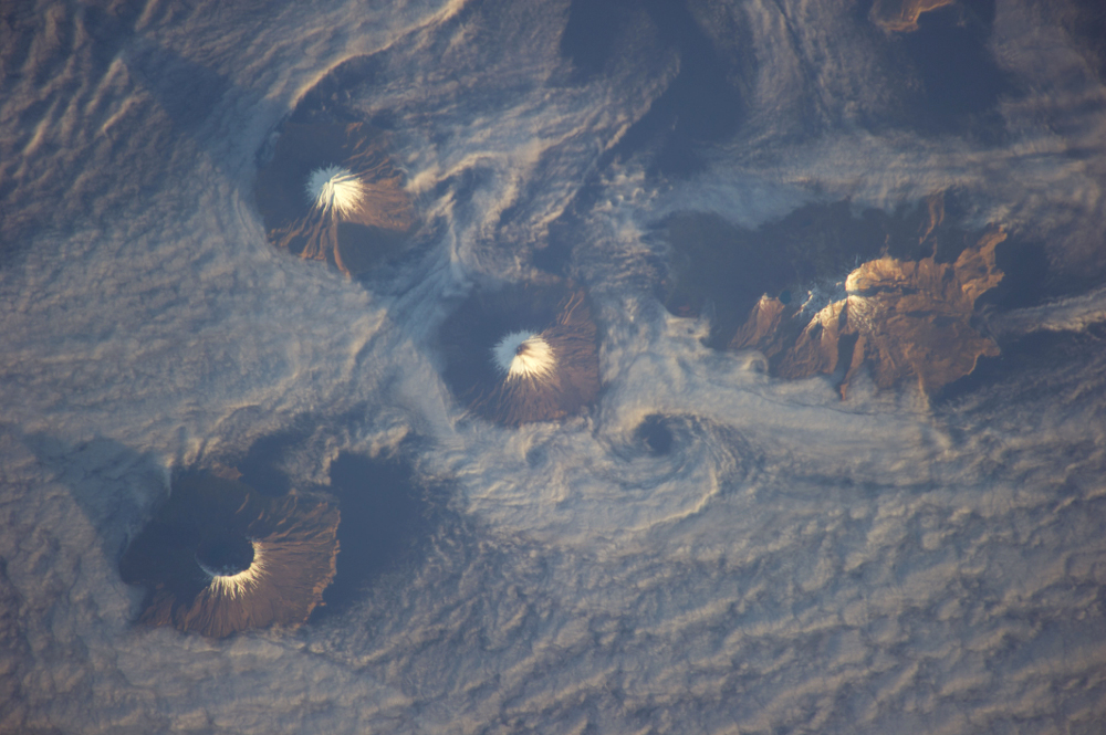
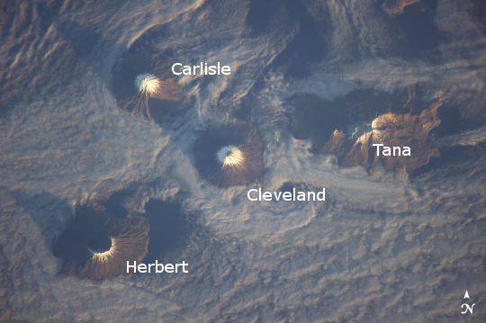
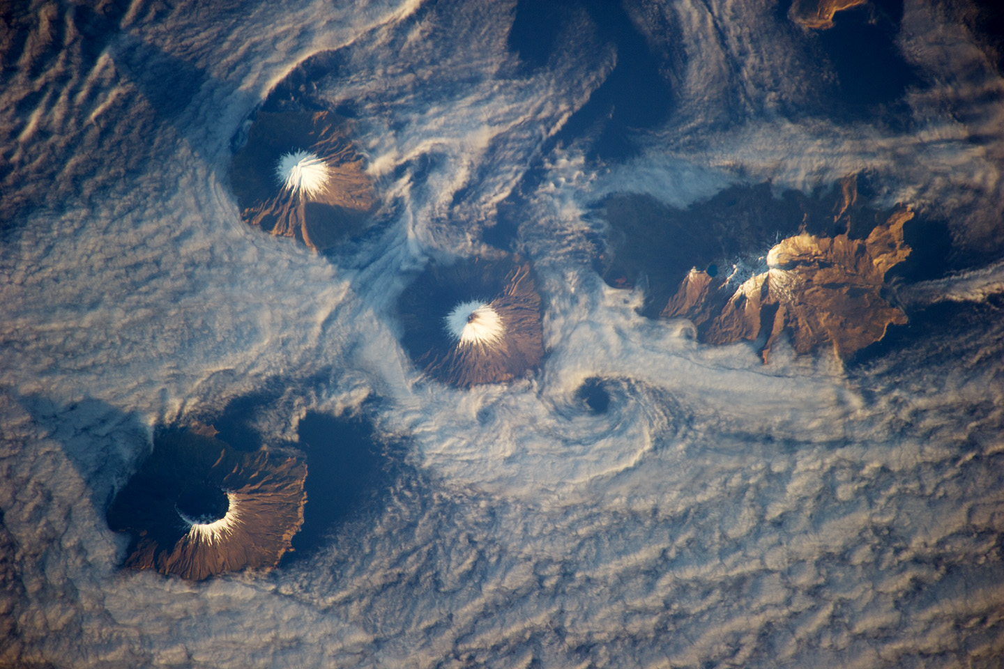
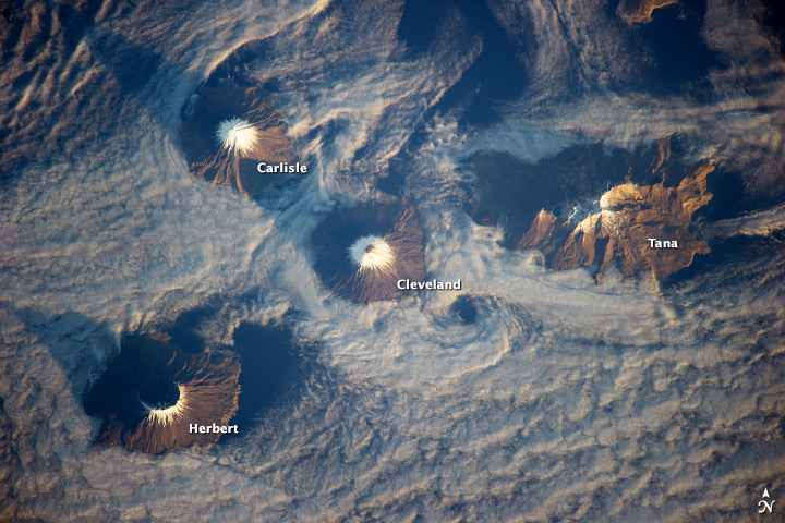
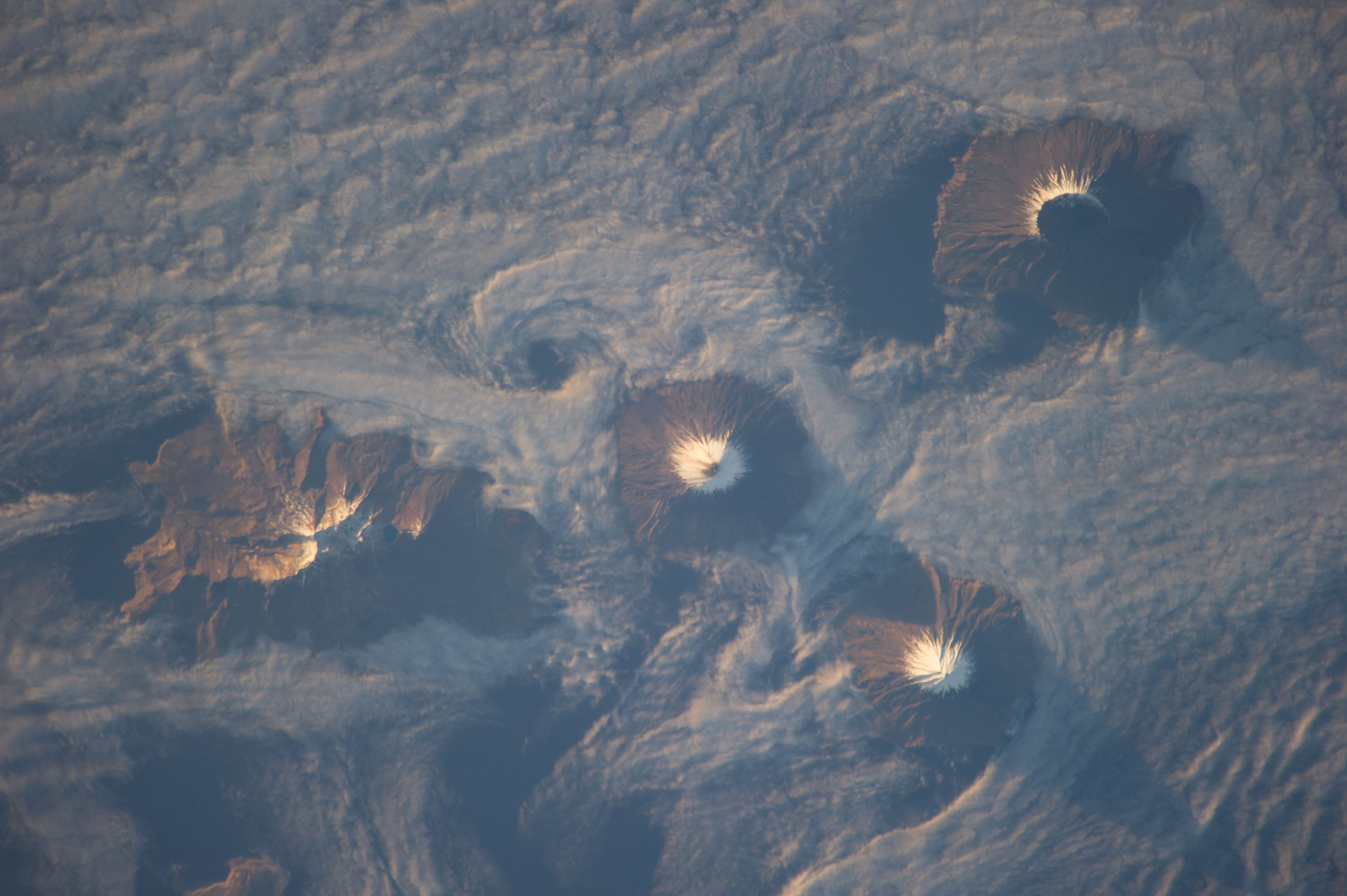
Image Caption: Islands of the Four Mountains, Aleutian Islands
Note: This caption refers to the image versions labeled "NASA's Earth Observatory web site".
Morning sunlight illuminates the southeast-facing slopes of the Islands of the Four Mountains in this astronaut photograph from the International Space Station. The islands, part of the Aleutian Island chain, are actually the upper slopes of volcanoes rising from the sea floor; Carlisle, Cleveland, Herbert, and Tana. Carlisle and Herbert volcanoes are distinct cones and form separate islands. Cleveland volcano and the Tana volcanic complex form the eastern and western ends respectively of Chuginadak Island; a cloud bank obscures the connecting land mass in this image.
Cleveland volcano (peak elevation 1730 meters above sea level, or asl) is one of the most active in the Aleutian chain, with its most recent activity--eruptions and lava flow emplacement--taking place in May of 2013 (crew aboard the ISS captured an earlier eruption in 2006). The northernmost of the islands, Carlisle volcano's (peak elevation 1620 meters asl) last confirmed eruption occurred in 1828, with unconfirmed reports of activity in 1987. Herbert volcano (peak elevation 1280 meters asl) to the southwest displays a classic cone structure breached by a 2-kilometer wide summit caldera (image lower left), but there are no historical records of volcanic activity. The easternmost peak, Tana (1170 meters asl) is a volcanic complex comprised of two east-west trending volcanoes and associated younger cinder cones; like Herbert volcano, there is no historical record of activity at Tana.
A layer of low cloud and/or fog obscures much of the lower elevations of the islands and the sea surface, but the clouds also indicate the general airflow pattern around and through the islands. Directly to the south-southeast of Cleveland volcano a Von Karman vortex street is visible. Shadows cast by the morning sun extend from the peaks towards the northwest. The peaks of all of the Four Islands have snow cover; this is distinct from the clouds due to both higher brightness (white versus gray) and specific location on the landscape.
