ISS038-E-35416
| NASA Photo ID | ISS038-E-35416 |
| Focal Length | 1000mm |
| Date taken | 2014.01.22 |
| Time taken | 15:17:40 GMT |
Resolutions offered for this image:
1000 x 786 pixels 540 x 424 pixels 1440 x 1440 pixels 720 x 480 pixels 6048 x 4032 pixels 640 x 427 pixels
1000 x 786 pixels 540 x 424 pixels 1440 x 1440 pixels 720 x 480 pixels 6048 x 4032 pixels 640 x 427 pixels

Spacecraft nadir point: 38.6° N, 109.1° W
Photo center point: 38.6° N, 110.0° W
Photo center point by machine learning:
Photo center point: 38.6° N, 110.0° W
Photo center point by machine learning:
Nadir to Photo Center: West
Spacecraft Altitude: 222 nautical miles (411km)
Country or Geographic Name: | USA-UTAH |
Features: | GREEN RIVER, BOWKNOT BEND, CONTRAIL |
| Features Found Using Machine Learning: | |
Cloud Cover Percentage: | 10 (1-10)% |
Sun Elevation Angle: | 8° |
Sun Azimuth: | 122° |
Camera: | Nikon D3X Electronic Still Camera |
Focal Length: | 1000mm |
Camera Tilt: | 14 degrees |
Format: | 6048E: 6048 x 4032 pixel CMOS sensor, 35.9mm x 24.0mm, total pixels: 25.72 million, Nikon FX format |
Film Exposure: | |
| Additional Information | |
| Width | Height | Annotated | Cropped | Purpose | Links |
|---|---|---|---|---|---|
| 1000 pixels | 786 pixels | No | Earth From Space collection | Download Image | |
| 540 pixels | 424 pixels | Yes | Earth From Space collection | Download Image | |
| 1440 pixels | 1440 pixels | No | No | NASA's Earth Observatory web site | Download Image |
| 720 pixels | 480 pixels | Yes | Yes | NASA's Earth Observatory web site | Download Image |
| 6048 pixels | 4032 pixels | No | No | Download Image | |
| 640 pixels | 427 pixels | No | No | Download Image |
Download Packaged File
Download a Google Earth KML for this Image
View photo footprint information
Download a GeoTIFF for this photo
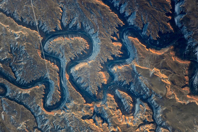
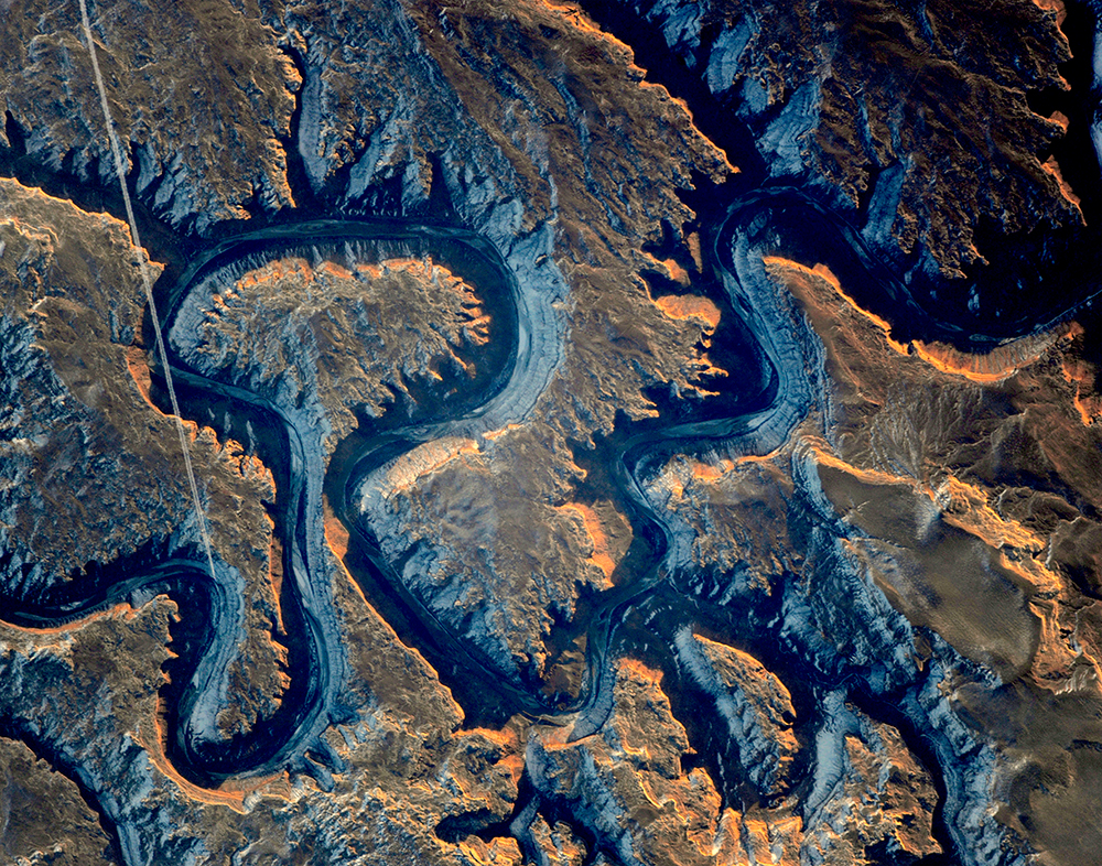
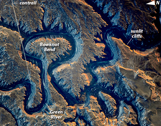
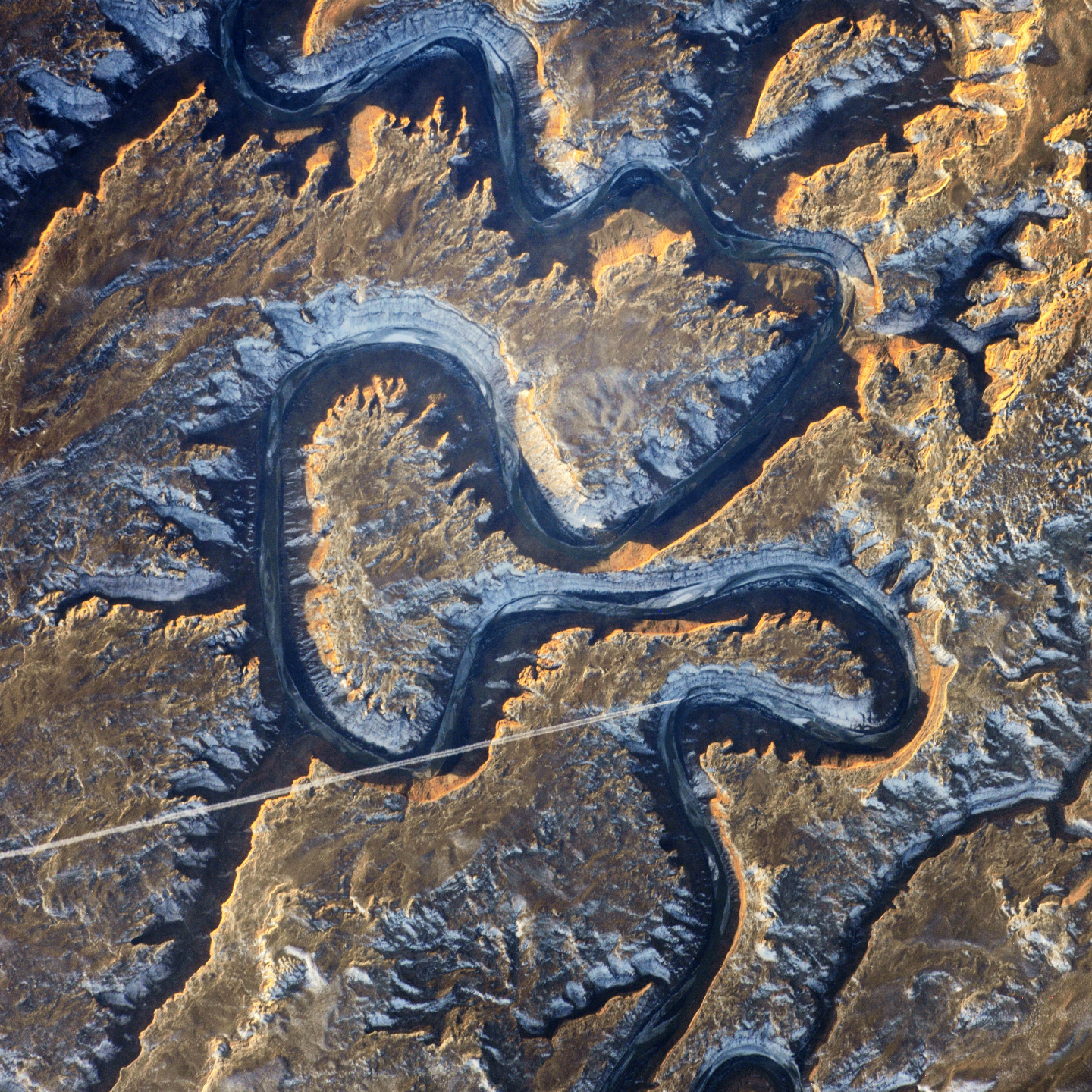
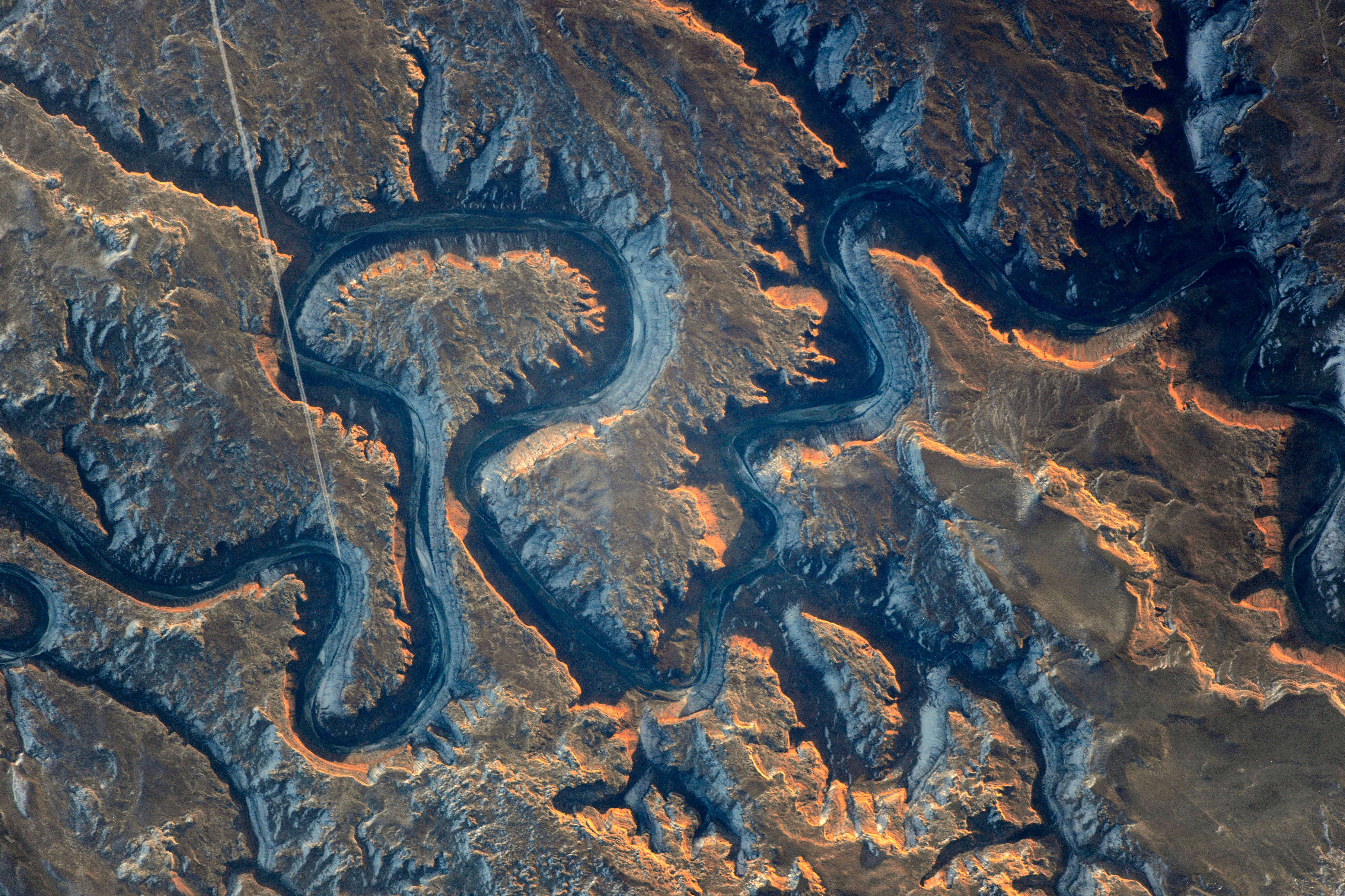
Image Caption: This sector of the Green River canyon in eastern Utah is known as Bowknot Bend because of the way the river doubles back on itself. The loop carries river rafters 14.5 kilometers (9 miles) before bringing them back to nearly the same point they started from--though on the other side of a low, narrow saddle (image center).
In this photograph taken by an astronaut on the International Space Station, the Green River appears dark because it lies in deep shadow, 300 meters (1,000 feet) below the surrounding landscape. The yellow-tinged cliffs that face the rising sun give a sense of the steep canyon walls. The straight white line across the scene is the contrail from a jet liner that passed over Bowknot Bend. Note that north is to the bottom of the image.
The reason for the tight bends in the Green River is the same as it is for the Mississippi: river courses often wind over time when they flow across a bed of relatively soft sediment in a floodplain. Geologists assume that the Green River, before its present canyon phase, once snaked across a wide valley on a bed of its own sediment and made a series of striking meander bends. Vertical uplift of the entire landscape--by deep-seated tectonic forces related to the growth of the Rocky Mountains--caused the Green River to erode downwards into the hard rocks under the valley. In the process, the present vertical-sided canyon was formed, preserving the tight loops reminiscent of an earlier time.
Bowknot was named by geologist John Wesley Powell in 1869 during one of his famous explorations of the rivers in the American West. The Green River flows south (toward the top of this image) and joins the Colorado River downstream. The combined flow of these rivers was responsible for cutting the Grand Canyon, some 325 kilometers (200 miles) away from Bowknot.
