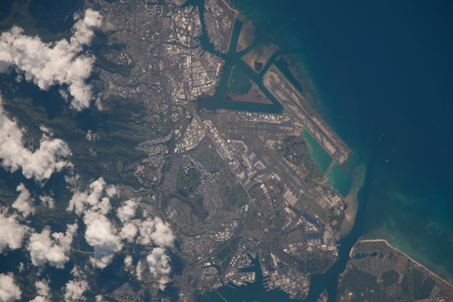
ISS038-E-34967
| NASA Photo ID | ISS038-E-34967 |
| Focal Length | 1200mm |
| Date taken | 2014.01.18 |
| Time taken | 21:39:06 GMT |


Spacecraft nadir point: 23.2° N, 163.1° W
Photo center point: 21.3° N, 157.9° W
Photo center point by machine learning:
Photo center point: 21.3° N, 157.9° W
Photo center point by machine learning:
Nadir to Photo Center: East
Spacecraft Altitude: 225 nautical miles (417km)
Country or Geographic Name: | USA-HAWAII |
Features: | HONOLULU, OAHU, JOINT BASE PEARL HARBOR-HICKAM, PACIFIC O., SAND I. |
| Features Found Using Machine Learning: | |
Cloud Cover Percentage: | 25 (11-25)% |
Sun Elevation Angle: | 42° |
Sun Azimuth: | 153° |
Camera: | Nikon D3X Electronic Still Camera |
Focal Length: | 1200mm |
Camera Tilt: | High Oblique |
Format: | 6048E: 6048 x 4032 pixel CMOS sensor, 35.9mm x 24.0mm, total pixels: 25.72 million, Nikon FX format |
Film Exposure: | |
| Additional Information | |
| Width | Height | Annotated | Cropped | Purpose | Links |
|---|---|---|---|---|---|
| 6048 pixels | 4032 pixels | No | No | Download Image | |
| 640 pixels | 427 pixels | No | No | Download Image |
Download Packaged File
Download a Google Earth KML for this Image
View photo footprint information
Download a GeoTIFF for this photo
Georeferenced by human interaction - exported 2016-08-16-230954-UTCGeoreferenced by human interaction - exported 2016-08-23-235839-UTC
Georeferenced by human interaction - exported 2018-01-16-144746-UTC
An explanation of the georeference file(s) above
Image Caption: none
