ISS038-E-3030
| NASA Photo ID | ISS038-E-3030 |
| Focal Length | 50mm |
| Date taken | 2013.11.14 |
| Time taken | 15:54:00 GMT |


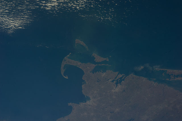
Spacecraft nadir point: 39.1° N, 69.3° W
Photo center point: 41.5° N, 70.5° W
Photo center point by machine learning:
Photo center point: 41.5° N, 70.5° W
Photo center point by machine learning:
Nadir to Photo Center: North
Spacecraft Altitude: 221 nautical miles (409km)
Country or Geographic Name: | USA-MASSACHUSETTS |
Features: | PUBLIC INPUTS (from public image detectives, not NASA): CAPE COD, NANTUCKET ISLAND, MASSACHUSETTS, RHODE ISLAND,BOSTON,USA, PLYMOUTH, MIDDLEBOROUGH, NEW BEDFORD, FALMOUTH, BARNSTABLE, ORLEANS, CHATHAM, NANTUCKET, 41.52,-70.54,BOSTON MA, PROVIDENCE RI, CAPE COD, MARTHA'S VINYARD, NANTUCKET ISLAND, BLOCK ISLAND, CAPE COD BAY, BUZZARDS BAY, THAMES RIVER, MERRIMACK RIVER |
| Features Found Using Machine Learning: | |
Cloud Cover Percentage: | 10 (1-10)% |
Sun Elevation Angle: | 32° |
Sun Azimuth: | 172° |
Camera: | Nikon D3S Electronic Still Camera |
Focal Length: | 50mm |
Camera Tilt: | 36 degrees |
Format: | 4256E: 4256 x 2832 pixel CMOS sensor, 36.0mm x 23.9mm, total pixels: 12.87 million, Nikon FX format |
Film Exposure: | |
| Additional Information | |
| Width | Height | Annotated | Cropped | Purpose | Links |
|---|---|---|---|---|---|
| 4256 pixels | 2832 pixels | No | No | Download Image | |
| 640 pixels | 426 pixels | No | No | Download Image |
Download Packaged File
Download a Google Earth KML for this Image
View photo footprint information
Download a GeoTIFF for this photo
Image Caption: none
